Willows, California
| Willows, California | |
|---|---|
| City | |
 The Willows Hardware store | |
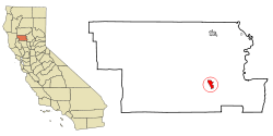 Location in Glenn County and the state of California | |
 Willows, California Location in the United States | |
| Coordinates: 39°31′28″N 122°11′37″W / 39.52444°N 122.19361°WCoordinates: 39°31′28″N 122°11′37″W / 39.52444°N 122.19361°W | |
| Country |
|
| State |
|
| County | Glenn |
| Incorporated | January 16, 1886[1] |
| Area[2] | |
| • Total | 2.87 sq mi (7.44 km2) |
| • Land | 2.85 sq mi (7.37 km2) |
| • Water | 0.03 sq mi (0.07 km2) 0.92% |
| Elevation[3] | 138 ft (42 m) |
| Population (2010) | |
| • Total | 6,166 |
| • Estimate (2016)[4] | 6,077 |
| • Density | 2,134.53/sq mi (824.21/km2) |
| Time zone | UTC-8 (Pacific (PST)) |
| • Summer (DST) | UTC-7 (PDT) |
| ZIP code | 95988 |
| Area code(s) | 530 |
| FIPS code | 06-85684 |
| GNIS feature IDs | 1660184, 2412272 |
| Website | cityofwillows.org |
Willows (formerly, Willow)[5] is a city in and the county seat of Glenn County, California. The city is a home to regional government offices, including the California Highway Patrol, California Department of Motor Vehicles, the United States Bureau of Reclamation and the main offices of the Mendocino National Forest, which comprises about one million acres of Federal land located mostly in mountainous terrain west of Willows. The population was 6,166 at the 2010 census, down from 6,220 at the 2000 census.
Geography
According to the United States Census Bureau, the city has a total area of 2.9 square miles (7.5 km2), of which, 2.8 square miles (7.3 km2) of it is land and 0.03 square miles (0.078 km2) of it (0.92%) is water.
Climate
Willows has a Hot-summer Mediterranean climate (Csa) according to the Köppen climate classification system.
| Climate data for Willows (1906-2012) | |||||||||||||
|---|---|---|---|---|---|---|---|---|---|---|---|---|---|
| Month | Jan | Feb | Mar | Apr | May | Jun | Jul | Aug | Sep | Oct | Nov | Dec | Year |
| Record high °F (°C) | 80 (27) |
81 (27) |
88 (31) |
101 (38) |
108 (42) |
113 (45) |
117 (47) |
115 (46) |
115 (46) |
105 (41) |
92 (33) |
81 (27) |
117 (47) |
| Average high °F (°C) | 54.6 (12.6) |
60.4 (15.8) |
65.7 (18.7) |
72.9 (22.7) |
81.3 (27.4) |
89.2 (31.8) |
95.2 (35.1) |
93.6 (34.2) |
89 (32) |
79.2 (26.2) |
65.5 (18.6) |
55.4 (13) |
75.2 (24) |
| Average low °F (°C) | 35.9 (2.2) |
39 (4) |
41.3 (5.2) |
44.9 (7.2) |
51.2 (10.7) |
57.6 (14.2) |
60.8 (16) |
58.7 (14.8) |
56 (13) |
49.4 (9.7) |
41.1 (5.1) |
36.3 (2.4) |
47.7 (8.7) |
| Record low °F (°C) | 15 (−9) |
21 (−6) |
21 (−6) |
23 (−5) |
31 (−1) |
38 (3) |
44 (7) |
42 (6) |
37 (3) |
30 (−1) |
22 (−6) |
11 (−12) |
11 (−12) |
| Average precipitation inches (mm) | 3.68 (93.5) |
3.14 (79.8) |
2.33 (59.2) |
1.12 (28.4) |
0.66 (16.8) |
0.33 (8.4) |
0.04 (1) |
0.09 (2.3) |
0.31 (7.9) |
1.01 (25.7) |
2.13 (54.1) |
3.13 (79.5) |
17.95 (455.9) |
| Average snowfall inches (cm) | 0.9 (2.3) |
0 (0) |
0 (0) |
0 (0) |
0 (0) |
0 (0) |
0 (0) |
0 (0) |
0 (0) |
0 (0) |
0 (0) |
0.4 (1) |
1.3 (3.3) |
| Average precipitation days | 10 | 9 | 8 | 5 | 4 | 2 | 0 | 0 | 1 | 4 | 7 | 9 | 59 |
| Source: WRCC[6] | |||||||||||||
History
The Willow post office opened in 1862; the name was changed to Willows in 1916.[5] The current post office building, which was built in 1918, is listed on the National Register of Historic Places.[7]
Demographics
| Historical population | |||
|---|---|---|---|
| Census | Pop. | %± | |
| 1880 | 728 | — | |
| 1890 | 1,176 | 61.5% | |
| 1900 | 893 | −24.1% | |
| 1910 | 1,139 | 27.5% | |
| 1920 | 2,190 | 92.3% | |
| 1930 | 2,024 | −7.6% | |
| 1940 | 2,215 | 9.4% | |
| 1950 | 3,019 | 36.3% | |
| 1960 | 4,139 | 37.1% | |
| 1970 | 4,085 | −1.3% | |
| 1980 | 4,777 | 16.9% | |
| 1990 | 5,988 | 25.4% | |
| 2000 | 6,220 | 3.9% | |
| 2010 | 6,166 | −0.9% | |
| Est. 2016 | 6,077 | [4] | −1.4% |
| U.S. Decennial Census[8] | |||
2010
The 2010 United States Census[9] reported that Willows had a population of 6,166. The population density was 2,146.2 people per square mile (828.7/km²). The racial makeup of Willows was 4,304 (69.8%) White, 78 (1.3%) African American, 138 (2.2%) Native American, 312 (5.1%) Asian, 11 (0.2%) Pacific Islander, 1,099 (17.8%) from other races, and 224 (3.6%) from two or more races. Hispanic or Latino of any race were 2,020 persons (32.8%).
The Census reported that 5,976 people (96.9% of the population) lived in households, 20 (0.3%) lived in non-institutionalized group quarters, and 170 (2.8%) were institutionalized.
There were 2,173 households, out of which 839 (38.6%) had children under the age of 18 living in them, 1,037 (47.7%) were opposite-sex married couples living together, 327 (15.0%) had a female householder with no husband present, 133 (6.1%) had a male householder with no wife present. There were 225 (10.4%) unmarried opposite-sex partnerships, and 7 (0.3%) same-sex married couples or partnerships. 538 households (24.8%) were made up of individuals and 228 (10.5%) had someone living alone who was 65 years of age or older. The average household size was 2.75. There were 1,497 families (68.9% of all households); the average family size was 3.28.
The population was spread out with 1,783 people (28.9%) under the age of 18, 614 people (10.0%) aged 18 to 24, 1,542 people (25.0%) aged 25 to 44, 1,445 people (23.4%) aged 45 to 64, and 782 people (12.7%) who were 65 years of age or older. The median age was 32.6 years. For every 100 females, there were 97.4 males. For every 100 females age 18 and over, there were 94.5 males.
There were 2,399 housing units at an average density of 835.0 per square mile (322.4/km²), of which 2,173 were occupied, of which 1,148 (52.8%) were owner-occupied, and 1,025 (47.2%) were occupied by renters. The homeowner vacancy rate was 2.3%; the rental vacancy rate was 8.8%. 3,137 people (50.9% of the population) lived in owner-occupied housing units and 2,839 people (46.0%) lived in rental housing units.
2000
As of the census[10] of 2000, there were 6,220 people, 2,134 households, and 1,513 families residing in the city. The population density was 2,168.5 people per square mile (836.8/km²). There were 2,368 housing units at an average density of 825.6 per square mile (318.6/km²). The racial makeup of the city was 69.3% White, 0.9% Black or African American, 2.3% Native American, 10.3% Asian, 0.2% Pacific Islander, 12.3% from other races, and 4.8% from two or more races. 23.3% of the population were Hispanic or Latino of any race.
There were 2,134 households out of which 38.5% had children under the age of 18 living with them, 52.1% were married couples living together, 14.2% had a female householder with no husband present, and 29.1% were non-families. 24.7% of all households were made up of individuals and 11.0% had someone living alone who was 65 years of age or older. The average household size was 2.83 and the average family size was 3.40.
In the city, the population was spread out with 32.7% under the age of 18, 9.6% from 18 to 24, 26.4% from 25 to 44, 19.0% from 45 to 64, and 12.4% who were 65 years of age or older. The median age was 31 years. For every 100 females, there were 98.1 males. For every 100 females age 18 and over, there were 92.4 males.
The median income for a household in the city was $27,466, and the median income for a family was $35,856. Males had a median income of $30,297 versus $22,159 for females. The per capita income for the city was $12,523. About 17.7% of families and 24.6% of the population were below the poverty line, including 39.6% of those under age 18 and 9.4% of those age 65 or over.
Politics
.jpg)
In the state legislature, Willows is in the 4th Senate District, represented by Republican Jim Nielsen,[11] and in the 3rd Assembly District, represented by Republican James Gallagher.[12]
Federally, Willows is in California's 3rd congressional district, represented by Democrat John Garamendi.[13]
Notable people
- Ace Adams, born in Willows, former major league baseball All-Star[14]
- Mark Koenig, baseball player for championship New York Yankees teams, died in Willows
References
- ↑ "California Cities by Incorporation Date" (Word). California Association of Local Agency Formation Commissions. Retrieved April 7, 2013.
- ↑ "2016 U.S. Gazetteer Files". United States Census Bureau. Retrieved Jun 28, 2017.
- ↑ "Willows". Geographic Names Information System. United States Geological Survey.
- 1 2 "Population and Housing Unit Estimates". Retrieved June 9, 2017.
- 1 2 Durham, David L. (1998). California's Geographic Names: A Gazetteer of Historic and Modern Names of the State. Clovis, Calif.: Word Dancer Press. p. 336. ISBN 1-884995-14-4.
- ↑ "WILLOWS 6 W, CA (049699)". Western Regional Climate Center. Retrieved December 3, 2015.
- ↑ National Park Service (2010-07-09). "National Register Information System". National Register of Historic Places. National Park Service.
- ↑ "Census of Population and Housing". Census.gov. Retrieved June 4, 2015.
- ↑ "2010 Census Interactive Population Search: CA - Willows city". U.S. Census Bureau. Retrieved July 12, 2014.
- ↑ "American FactFinder". United States Census Bureau. Retrieved 2008-01-31.
- ↑ "Senators". State of California. Retrieved April 7, 2013.
- ↑ "Members Assembly". State of California. Retrieved April 7, 2013.
- ↑ "California's 3rd Congressional District - Representatives & District Map". Civic Impulse, LLC. Retrieved March 1, 2013.
- ↑ Reichler, Joseph L., ed. (1979) [1969]. The Baseball Encyclopedia (4th ed.). New York: Macmillan Publishing. ISBN 0-02-578970-8.
External links
| Wikimedia Commons has media related to Willows, California. |
Municipalities and communities of Glenn County, California, United States | ||
|---|---|---|
| Cities | 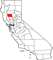 | |
| CDPs | ||
| Unincorporated communities | ||
| Indian reservations | ||
| Ghost towns | ||