Highbridge, Wisconsin
| Highbridge, Wisconsin | |
|---|---|
| Unincorporated community | |
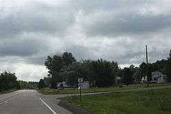 Looking south at Highbridge | |
 Highbridge  Highbridge | |
| Coordinates: 46°23′20″N 90°44′11″W / 46.38889°N 90.73639°WCoordinates: 46°23′20″N 90°44′11″W / 46.38889°N 90.73639°W | |
| Country | United States |
| State | Wisconsin |
| County | Ashland |
| Town | Ashland |
| Elevation | 997 ft (304 m) |
| Time zone | UTC-6 (Central (CST)) |
| • Summer (DST) | UTC-5 (CDT) |
| ZIP code | 54846 |
| Area code(s) | 715 & 534 |
| GNIS feature ID | 1566371[1] |
Highbridge (also spelled High Bridge) is an unincorporated community located in the town of Ashland, Ashland County, Wisconsin, United States. Highbridge is located on Wisconsin Highway 13 6 miles (9.7 km) northwest of Mellen. Highbridge has a post office with ZIP code 54846.[2]
Climate
The climate is described as Humid Continental by the Köppen Climate System, abbreviated as Dfb.[3]
| Climate data for Highbridge, Wisconsin | |||||||||||||
|---|---|---|---|---|---|---|---|---|---|---|---|---|---|
| Month | Jan | Feb | Mar | Apr | May | Jun | Jul | Aug | Sep | Oct | Nov | Dec | Year |
| Average high °C (°F) | −6 (22) |
−3 (27) |
3 (37) |
11 (52) |
19 (66) |
23 (74) |
26 (79) |
25 (77) |
20 (68) |
13 (56) |
4 (39) |
−3 (26) |
11 (52) |
| Average low °C (°F) | −18 (0) |
−17 (2) |
−10 (14) |
−2 (28) |
4 (39) |
9 (49) |
12 (54) |
11 (52) |
7 (44) |
1 (34) |
−6 (22) |
−14 (7) |
−2 (29) |
| Average precipitation mm (inches) | 33 (1.3) |
30 (1) |
43 (1.7) |
64 (2.5) |
89 (3.5) |
100 (4) |
104 (4.1) |
100 (4) |
97 (3.8) |
74 (2.9) |
58 (2.3) |
36 (1.4) |
826 (32.5) |
| Source: Weatherbase [4] | |||||||||||||
Images
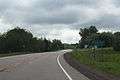 Sign on WIS 13
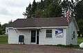 Post office
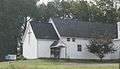 St. Anthony Catholic Church in Highbridge
References
- ↑ U.S. Geological Survey Geographic Names Information System: Highbridge, Wisconsin
- ↑ ZIP Code Lookup
- ↑ Climate Summary for Highbridge, Wisconsin
- ↑ "Weatherbase.com". Weatherbase. 2013. Retrieved on August 23, 2013.
Municipalities and communities of Ashland County, Wisconsin, United States | ||
|---|---|---|
| Cities | 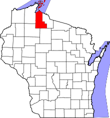 | |
| Village | ||
| Towns | ||
| CDPs | ||
| Unincorporated communities | ||
| Indian reservation | ||
| Footnotes | ‡This populated place also has portions in an adjacent county or counties | |
This article is issued from
Wikipedia.
The text is licensed under Creative Commons - Attribution - Sharealike.
Additional terms may apply for the media files.