Hesbaye
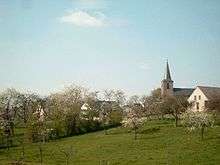
The Hesbaye (French), or Haspengouw (modern Dutch, medieval Latin: Hasbania or less often Haspinga[1]) is a geophysical region in Belgium, a plateau region of low, fertile hills, running parallel with the northern bank of a section of the Maas river that flows from west to east.
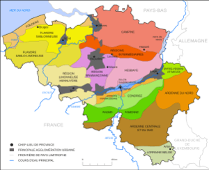
Significant parts of three Belgian provinces are dominated by the Hesbaye landscape, important for both tourism and agriculture: the southern half of the province of Limburg, the northwestern part of Liège province (north of the Maas), and eastern Walloon Brabant. Parts are also in neighbouring provinces: southeastern Flemish Brabant, the northern edge of Namur province and the northwestern corner of Hainaut. The Limburg portion includes the cities of Tongeren, Sint-Truiden, Bilzen and Borgloon, the Flemish Brabant portion includes Tienen, Landen and Zoutleeuw, the Walloon Brabant portion includes Jodoigne and Perwez, Namur's part includes Éghezée, and in Liège province there are for example the towns of Hannut and Waremme.[2]
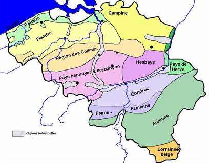
Geographically, Hesbaye borders on two similar regions of rolling hills: to the west Hageland (which was historically also considered part of the Hesbaye), on the other side of the river Maas to the south is the Condroz, and to the east Dutch "South Limburg" and the Pays de Herve. In contrast, to the north it borders on the flat sandy Kempen region. And over the Maas to the southeast are the rocky hills of the Ardennes. In the west the plateau ends at the valley of the Dyle river, except to its south where a smaller extension of the plateau landscape stretches into Hainaut and between Brussels and Charleroi, sometimes referred to as the "plateau brabançonne".[3]
The fertile ground of this region's rolling countryside is mainly used for agricultural purposes, and in this context it is often divided into two divisions, with the boundary running through Sint-Truiden, Borgloon and Tongeren. The northern "Humid" (Dutch Vochtig) part has a high water table and many springs; it is by far the main fruit growing area of Belgium, as well as home to some of the most northerly vineyards in Belgium. The southern "Dry" division is somewhat more fertile and the ground water sinks more easily; in this region sugar beet, chicory, flax, rapeseed and grains (90% of which is wheat and barley) are cultivated.[4]
Name
In the oldest Latin documents the name of the pagus (country or territory) was typically Hasbania, and sometimes this was given in an adjectival form, pagus hasbaniensis. Only a small number of such records add the Germanic word gau or gouw. Verhelst (p.245 n.45) proposed that the small number cases of medieval Latin which include the "gau" ending are un-coincidentally in or near the old deaconry of Tongeren, which he proposed to be the historical core of the Hesbaye. Therefore, he proposed, the terms Hasbania and Haspengouw can not be assumed to have identical meanings in all records, even though in modern Dutch the form with "gouw" is now the only one, while in modern French the form without is the only one.
Latin continued to be use in documentation in the Belgian area into the early modern era, and it has been noted that spelling variations sometimes even included Hispania (or similar) which would usually refer to geographical area containing Spain and Portugal.[5]
History
In Roman times, Haspengouw lay in the fertile agricultural centre of the Civitas Tungrorum, containing its capital in Tongeren, and with sandy Toxandria to the north of it in the Campine, and the rocky hills of the Ardennes and other forests over the Maas to the south. The Salian Franks were allowed to settle in Toxandria in the 4th century, while the more heavily populated Haspengouw remained more Romanized. Frankish power however eventually extended over neighbouring Romans. From at least the eighth century Hesbaye was an important geographical division in the Merovingian Frankish kingdom of Austrasia.
In the 8th century, Robert, who has been proposed as an ancestor of the Capetians, was described as a Duke of Hasbania (in Latin), so in his lifetime maybe it formed one large political area. In a grant of 741 there is also mention of the country of "Hasbaniensi et Masuarinsi", the Hasbanians and the Masuarini.
Later, Hasbania was mentioned in the division of territories between Charles the Bald and Louis the German in 870 in the Treaty of Meerssen, which specifically mentions that it had four counties at that time. Its exact boundaries are unclear but it may have stretched as far west as Leuven and the River Dyle. Judging from the ancient catholic Archdeaconry of Hesbaye, it may also have stretched to the east of the Maas river.[6]
In the 10th century, counties considered to have been within the country of Hesbaye included a County of Avernas (with its capital town in modern Hannut), a county which was itself called Haspinga, possibly between the Jeker River and the Meuse, and the County of Huste or Hufte, which is believed to be the same as modern Hocht (in modern Lanaken).[7] It is possible that Vliermaal played a role in a county also, for example in Hocht, because in later times it was a court town for the County of Loon. (Because the region may have been considered much bigger, it is likely that some counties in modern Flemish Brabant and Liège were also included, for example the County of Leuven.[8]) In the west an apparently short-lived and small county named Brunengeruz was absorbed by the growing power of the westernmost county based in Louvain/Leuven.
In the 11th century, Avernas was replaced by the County of Duras, covering similar territory but with a new seat. And similarly, Hocht is replaced by the County of Loon, with its seat now in Borgloon. Along with Louvain, whose power indeed proceeded to expand beyond the region, these two counties proved to be lasting.
In 1040, the Emperor Henry III recognized a fiefdom called Hasbania as being under the prince-bishop Nithard of Liège. This Hasbania may have been one of the smaller counties within the Hesbaye, but it seems that the important County of Loon, which had formed out of the Counties of Avernas and Hocht, was considered to be held under it. Much later, the County of Loon was integrated it with the Prince-Bishopric of Liège.[9] Areas to the west of Loon came under the increasing power of the County of Brabant.
Today Hesbaye continues to be rural, with many small villages. Théo Brulard, La Hesbaye. Étude géographique d'économie rurale (Louvain) 1962, attempted to disengage the original aspect of the region from its open, deforested agricultural aspect of modern times, characterising Hesbaye as a human region rather than a natural one.
See also
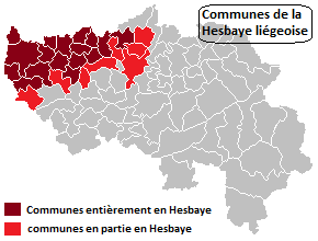
- Hesbaye liégeoise
Notes
- ↑ Graesse, Johann Georg Theodor / Benedict, Friedrich: Orbis latinus, Lexikon lateinischer geographischer Namen des Mittelalters und der Neuzeit, Großausg. / bearb. und hrsg. von Helmut Plechl ..., Bd.: 2, E - M, Braunschweig, 1972, pg. 214
- ↑ See for example the tourism websites for the Hesbaye Brabançonne in Walloon Brabant, the Hesbaye namuroise in Namur, the Hesbaye Meuse area in Liège.
- ↑ "Plateaux brabançon et hesbignon"
- ↑ "Vlaams infocentrum land- en tuinbouw - Zeg nooit Vochtig-Haspengouw tegen Droog-Haspengouw - VILT". Vilt.be. 2006-07-22. Retrieved 2014-07-10.
- ↑ Wegman, Rob, "Jacobus de Ispania and Liège", Journal of the Alamire Foundation, 8 (2): 253–274, doi:10.1484/J.JAF.5.111881
- ↑ Verhelst (1984 and 1985) "Een nieuwe visie op de omvang en indeling van de pagus Hasbania" Handelingen van de Koninklijke Zuidnederlandsche Maatschappij voor Taal- en Letterkunde en Geschiednis"
- ↑ There are still debates about these three counties. For example, another more unusual Latin form, Haspinga contains -ga which is the same as the -gouw of the modern Dutch name: Gau was an old Frankish term for a small geographical "country", equivalent to the French pays, or Latin pagus. It has been proposed that this term refers to only a part of great Haspengouw, although there is no consensus on this.
- ↑ Vanderkindere, Léon (1902), "9", La formation territoriale des principautés belges au Moyen Age (PDF), 2, p. 128
- ↑ Baerten (1965), "Les origines des comtes de Looz et la formation territoriale du comté", Revue belge de philologie et d'histoire, 43 (2): 468 and Baerten (1965), "Les origines des comtes de Looz et la formation territoriale du comté (suite et fin)", Revue belge de philologie et d'histoire, 43 (4)
External links
| Wikimedia Commons has media related to Hesbaye. |
- Hesbaye brabançonne et pays de Hannut
- DOCUMENT: CARTE COMPLÈTE : BELGIQUE, RÉGIONS NATURELLES
- Rolf Badenhausen, "Merovingians by the Svava?" Identifying Didrek of the Old Swedish Thidrekssaga with Theuderich, son of Clovis; includes Geographic glossary of placenames
|  | |