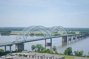
Hernando de Soto Bridge
| Hernando de Soto Bridge | |
|---|---|
 Hernando de Soto Bridge photographed from the Memphis Pyramid | |
| Coordinates | 35°09′10″N 90°03′50″W / 35.15278°N 90.06389°WCoordinates: 35°09′10″N 90°03′50″W / 35.15278°N 90.06389°W |
| Carries |
6 lanes of |
| Crosses | Mississippi River |
| Locale | West Memphis, Arkansas, and Memphis, Tennessee |
| Other name(s) | The M Bridge, Memphis Bridge, Mississippi Bridge, New Bridge |
| Maintained by | TDOT and AHTD |
| ID number | 79I00400001 |
| Characteristics | |
| Design | Continuous cantilevered (cable-stayed) steel through arch, with bedstead end posts |
| Total length | 9,432.6 feet (2,875 m) |
| Width | 90 feet (27 m) |
| Longest span | 900 feet (274 m) each |
| Clearance below | 109 feet (33 m) (varies some due to river level) |
| History | |
| Opened | August 2, 1973 |
| Statistics | |
| Daily traffic | 43,000 (2008) |
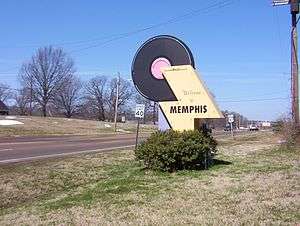
The Hernando de Soto Bridge is a through arch bridge carrying Interstate 40 across the Mississippi River between West Memphis, Arkansas, and Memphis, Tennessee. The archictectural design is a continuous cantilevered cable-stayed steel through arch, with bedstead endposts. Memphians also call the bridge the "New Bridge",[1] as it is newer than the Memphis & Arkansas Bridge (carrying Interstate 55) downstream, and the "M Bridge", due to its distinctive shape. It is of similar construction to the Sherman Minton Bridge between Louisville, Kentucky, and New Albany, Indiana.
History
Preliminary planning for the river crossing began in 1960 as part of Interstate 40 alignment studies for the Memphis - Little Rock corridor, which was constructed in segments between 1963 and 1968. Before the Hernando de Soto Bridge was completed, Interstate 40 traffic was carried across the Mississippi River by the Interstate 55 Memphis & Arkansas Bridge crossing, located two miles southwest.
Construction of the Hernando de Soto Bridge began in May 1967. The double-arch bridge was opened to automobile traffic on August 2, 1973. It was seismically retrofitted in 2006.
The bridge is named for 16th century Spanish explorer Hernando de Soto who explored this stretch of the Mississippi River, and died south of Memphis. His body was believed to have been buried in the Mississippi River after his death (although, according to legend, his body lay at the bottom of Lake Chicot in Arkansas, an oxbow lake of the Mississippi River about 130 miles south of Memphis.)
Incidents
On August 23, 2007, an inspector discovered that a bridge pier on the approach bridge west of the river had settled overnight, and the bridge was subsequently closed to perform a precautionary inspection. The bridge was reopened later that day.[2]
Bridge illumination
At night, the bridge is illuminated by 200 sodium vapor lights along its "M" shape structure. The bridge was first lit on September 5, 1986, after $373,000 of private funds had been raised to fund the cost and installation of the lights. Due to some river traffic having issues with the lights at night reflecting on the water, the city installed a remote switch to toggle the lights on and off briefly while the vessel passes under the bridge.[3] During the 2011 Mississippi River floods, the bridge became dark for about 2 months because the transformers that supply the electricity for the lights were removed to prevent damage to them by flood waters. The bridge was re-lit in a ceremony which occurred on June 21, 2011.
It was announced soon after the opening of the Big River Crossing along the Harahan Bridge to the south that the existing sodium vapor lights along the Hernando Desoto Bridge would be replaced with a new LED lighting display, thus making the Hernando Desoto Bridge the second bridge over the Mississippi River to be lit as such after the Harahan. The new display can be lit in sync with the Harahan Bridge and display various color patterns dependent upon special occasions or requests. Both displays have been created under an initiative called "Mighty Lights." The $14 million privately-funded project is expected to begin June 4 and be unveiled October 27, nearly exactly 2 years after the opening/initial illumination of the Big River Crossing. [4]
Seismic retrofit project
Since 2000, the bridge has been under a seismic retrofitting project, which allows it to withstand a 7.7 magnitude earthquake. This is being done since the bridge is located within the New Madrid Seismic Zone and would not have been able to sustain that magnitude of an earthquake. Work is being completed as funds are available. As part of this project, the main span, approaches, and ramps for the downtown exit are being retrofitted. A bridge about 1 mile west of the main span was rebuilt with earthquake considerations. As the main span (the "M" portion) is located entirely within Tennessee, the funding formula is split 60%/40% between TDOT and AHTD. To date, $175 million has been spent with another $80 million expected.[5]
Black Lives Matter protest
On July 11, 2016, a group of approximately 45 Black Lives Matter protestors blocked traffic on the bridge for several hours. They were protesting the recent killings nationwide of black citizens by police officers.
Gallery
 Hernando de Soto Bridge from Martyr's Park in Memphis
 Hernando de Soto Bridge illuminated at night
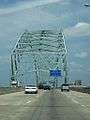 Crossing into Memphis on the Hernando de Soto Bridge
See also


- List of crossings of the Lower Mississippi River
References
- ↑ Teresa R. Simpson (2008-02-17). "About.com:Memphis:The Mississippi River". About.com. Archived from the original on 2008-11-18. Retrieved 2008-11-11.
- ↑ Chris Conley, Richard Locker (2007-08-27). "Bridge reopens after review". Commercial Appeal. Memphis, TN. Archived from the original on 2011-05-17. Retrieved 2008-04-21.
- ↑ "The Commercial Appeal". The Commercial Appeal. Archived from the original on 17 October 2012. Retrieved 26 April 2018.
- ↑ Tom Charlier (29 May 2018). "The Commercial Appeal". The Commercial Appeal. Retrieved 29 May 2018.
- ↑ "TDOT". www.tdot.state.tn.us. Archived from the original on 26 April 2018. Retrieved 26 April 2018.
External links
Crossings of the Mississippi River | ||||
|---|---|---|---|---|
| ||||