Heinsberg
| Heinsberg | ||
|---|---|---|
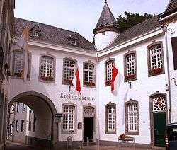 Kreismuseum in Torbogenhaus | ||
| ||
 Heinsberg Location of Heinsberg within Heinsberg district 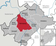  | ||
| Coordinates: 51°03′47″N 06°05′47″E / 51.06306°N 6.09639°ECoordinates: 51°03′47″N 06°05′47″E / 51.06306°N 6.09639°E | ||
| Country | Germany | |
| State | North Rhine-Westphalia | |
| Admin. region | Köln | |
| District | Heinsberg | |
| Government | ||
| • Mayor | Wolfgang Dieder (CDU) | |
| Area | ||
| • Total | 92.14 km2 (35.58 sq mi) | |
| Elevation | 76 m (249 ft) | |
| Population (2016-12-31)[1] | ||
| • Total | 41,471 | |
| • Density | 450/km2 (1,200/sq mi) | |
| Time zone | CET/CEST (UTC+1/+2) | |
| Postal codes | 52525 | |
| Dialling codes | 02452 | |
| Vehicle registration | HS | |
| Website | www.heinsberg.de | |

Heinsberg is a town in North Rhine-Westphalia, Germany. It is the seat of the district Heinsberg. It is situated near the border with the Netherlands, on the river Wurm, approx. 20 km north-east of Sittard and 30 km south-west of Mönchengladbach.
Geography
Wassenberg is the town to the North of Heinsberg, Hückelhoven to the east, Waldfeucht and Gangelt to the west, and Geilenkirchen to the south. Two rivers flow through Heinsberg, the Wurm and the Rur. The Wurm flows into the Rur near to Rurkempen, a village of Heinsberg municipality.
History
![]()
![]()
![]()
![]()
![]()
![]()
![]()
![]()
![]()
![]()
![]()
![]()
![]()
![]()
![]()

Sights

The city of Heinsberg has only some old houses. The most of the city is destroyed in 1944. The main sights are:
- St. Gangolf church
- Castle ruins
- Old district court
- Building assembly of Propstei, Torbogenhaus (former seat of the Amtmann of the Duchy of Jülich) and the former Haus Lennartz.
Transport
Railway
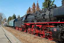
The railway from Heinsberg to Lindern, on the Aachen–Mönchengladbach railway, has been reopened for passenger traffic in December 2013. Passenger traffic had been suspended in 1980.[2] As of 2015, there is an hourly service from Heinsberg station to Lindern, which continues to Aachen Hbf.[3]
Bus
The main bus station of Heinsberg is next to the train station. It is served by buses to several towns and villages in the district, including Erkelenz, Geilenkirchen, Wegberg, Gangelt, Waldfeucht and Selfkant-Tüddern. There is one swift bus, the SB 1 from Erkelenz to Geilenkirchen via Heinsberg.
Road
Heinsberg has two exits on the motorway A46 to Düsseldorf. The Bundesstraße 221 (Alsdorf - Straelen) passes through the town.
Industry
In the industry area of Heinsberg, and the industry area of Oberbruch (IPO) are many companies, very famous;
- Enka Gmbh & Co KG
- Hazet (tool company)
- Sera Aquaristic
Media
- Heinsberger Newspaper
- "Hs-Woche" a free weekly newspaper
- The "Lokalzeit aus Aachen" a news broadcast from the WDR about Aachen and Heinsberg, too.
- HS TV, a television transmitter
- The radio transmitter "Welle West" was closed in 2007. Other radio stations, which include 100.5 and 107.8, provide news and weather reports for Heinsberg
Public Facilities
- Office of the district Heinsberg
- Police (district)
- the district court
- health office
- jail
Creation and Schools
In Heinsberg possesses many elementary schools and kindergartens. There are two "Hauptschulen" and "Realschulen". There is a high school ("Gymnasium") in Heinsberg. Since 2007 there is a school for handicaped persons in the building of the former vocational school ("Berufschule").
References
- ↑ "Amtliche Bevölkerungszahlen" (in German). Landesbetrieb Information und Technik NRW. Retrieved 2018-02-24.
- ↑ wurmtalbahn.de
- ↑ Deutsche Bahn timetable 485
External links
- Official site (in German)
Towns and municipalities in Heinsberg (district) | ||
|---|---|---|
| Authority control |
|---|