Übach-Palenberg
| Übach-Palenberg | ||
|---|---|---|
 Übach seen from the church | ||
| ||
 Übach-Palenberg Location of Übach-Palenberg within Heinsberg district 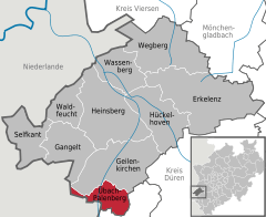  | ||
| Coordinates: 50°55′11″N 6°7′10″E / 50.91972°N 6.11944°ECoordinates: 50°55′11″N 6°7′10″E / 50.91972°N 6.11944°E | ||
| Country | Germany | |
| State | North Rhine-Westphalia | |
| Admin. region | Köln | |
| District | Heinsberg | |
| Government | ||
| • Mayor | Wolfgang Jungnitsch (CDU) | |
| Area | ||
| • Total | 26.11 km2 (10.08 sq mi) | |
| Elevation | 110 m (360 ft) | |
| Population (2016-12-31)[1] | ||
| • Total | 24,198 | |
| • Density | 930/km2 (2,400/sq mi) | |
| Time zone | CET/CEST (UTC+1/+2) | |
| Postal codes | 52531 | |
| Dialling codes |
02451 02404 (Parts of Boschelns) | |
| Vehicle registration | HS | |
| Website | www.uebach-palenberg.de | |

Übach-Palenberg is a town in the Heinsberg district of North Rhine-Westphalia, Germany.
Geography
The town is located at the border with the Netherlands, at approx. 10 km east of Heerlen and 15 km north of Aachen. The river Wurm flows through the area. The town has an area of 26.106 km². More than half the area is agricultural.
History
- 867 the village Palenberg was first mentioned in a written document, 1172 the village Übach. 1794 three Bürgermeistereien were created - Übach, Scherpenseel, Frelenberg - which were merged into one municipality in 1935. 1967 it received town rights.
- 1917 coal mining was started in the town, until in 1962 the Carolus Magnus coal-mine was closed.
International relations
Übach-Palenberg has two twin towns; since 1989 with Rosny-sous-Bois, (France) and since 1999 neighbouring Landgraaf, (Netherlands).
Coat of arms
The coat of arms of the town is subdivided into three fields. In the top blue field are two crossed golden scepter with a lily head, with a black letter T on top. Both symbols refer to the Grundherrschaft Thorn. In the left golden field is a black lion, the symbol of Jülich, as both Frelenberg and Palenberg belonged to the county Jülich. To the right is a silver lion on a red field, the symbol of Heinsberg, where Scherpenseel belonged to historically. The coat of arms were granted on December 2, 1937 by the Oberpräsident of the province Rhineland.
Economy
In addition to international companies such as SLV, Neuman & Esser, Schlafhorst or Spanset the company Solent GmbH & Co. KG produces chocolate, nuts and dried fruit for various brands in Übach-Palenberg since 2010.[2] The sister company Bonback GmbH & Co. KG produces at the same location as a wholesale bakery.[3]
References
- ↑ "Amtliche Bevölkerungszahlen" (in German). Landesbetrieb Information und Technik NRW. Retrieved 2018-02-24.
- ↑ Solent-Schokolade (in German)
- ↑ Bakery Bonback (in German)
External links
- Official website

Gallery
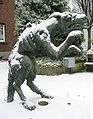 "Der Platschhonk", a legendary creature
| Wikimedia Commons has media related to Übach-Palenberg. |
Towns and municipalities in Heinsberg (district) | ||
|---|---|---|
| Authority control |
|---|