Havelock Parish, New Brunswick
| Havelock | |
|---|---|
| Parish | |
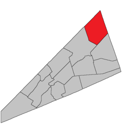 Location within Kings County, New Brunswick. | |
| Coordinates: 45°50′N 64°35′W / 45.84°N 64.59°W | |
| Country |
|
| Province |
|
| County | Kings County |
| Established | 1858 |
| Area[1] | |
| • Land | 349.34 km2 (134.88 sq mi) |
| Population (2011)[1] | |
| • Total | 1,158 |
| • Density | 3.3/km2 (9/sq mi) |
| • Pop 2006-2011 |
|
| • Dwellings | 583 |
| Time zone | UTC-4 (AST) |
| • Summer (DST) | UTC-3 (ADT) |
Havelock is a Canadian parish in Kings County, New Brunswick.[2]
History
Havelock Parish established in 1858 from Studholm Parish: named for Sir Henry Havelock (1795-1857), a hero of the Crimean War from 1853-1856, who died in India following the relief of Lucknow in 1857.
Delineation
Havelock Parish is defined in the Territorial Division Act[3] as being bounded:
- West by Studholm Parish; northwest and east by the County lines, and south by Cardwell Parish.
Communities
Parish population total does not include incorporated municipalities (in bold):
Bodies of water & Islands
This is a list of rivers, lakes, streams, creeks, marshes and Islands that are at least partially in this parish
- None
Demographics
Access Routes
Highways and numbered routes that run through the parish, including external routes that start or finish at the parish limits:[6]
|
|
|
|
See also
References
- 1 2 2011 Statistics Canada Census Profile: Havelock Parish, New Brunswick
- ↑ New Brunswick Provincial Archives -Havelock Parish
- ↑ "Territorial Division Act (R.S.N.B. 1973, c. T-3)". Government of New Brunswick website. Retrieved 23 August 2016.
- ↑ Statistics Canada: 2001, 2006 census
- ↑ Profile: Havelock Parish, New Brunswick
- ↑ Atlantic Canada Back Road Atlas ISBN 978-1-55368-618-7
Places adjacent to Havelock Parish, New Brunswick | ||||||||||
|---|---|---|---|---|---|---|---|---|---|---|
| ||||||||||
| Subdivisions | |
|---|---|
| Cities | |
| Counties | |
| |
Coordinates: 45°56′05″N 65°24′37″W / 45.934736°N 65.410366°W
This article is issued from
Wikipedia.
The text is licensed under Creative Commons - Attribution - Sharealike.
Additional terms may apply for the media files.