Harwood, Arkansas
| Harwood, Arkansas | |
|---|---|
| Unincorporated community | |
 Harwood  Harwood | |
| Coordinates: 33°09′46″N 91°07′41″W / 33.16278°N 91.12806°WCoordinates: 33°09′46″N 91°07′41″W / 33.16278°N 91.12806°W | |
| Country | United States |
| State | Arkansas |
| County | Chicot |
| Elevation | 118 ft (36 m) |
| Time zone | UTC-6 (Central (CST)) |
| • Summer (DST) | UTC-5 (CDT) |
| Area code(s) | 870 |
| GNIS feature ID | 57051[1] |
Harwood is an unincorporated community in Chicot County, Arkansas, United States.[1]
In 1915, it was the site of the 5,000-acre Florence Plantation.[2]
Notes
- 1 2 "Harwood, Arkansas". Geographic Names Information System. United States Geological Survey.
- ↑ "A BARONIAL ESTATE AT THE PRICE OF A FARM". Daily Arkansas Gazette. Little Rock, Arkansas. January 10, 1915. p. 36. Retrieved September 11, 2017 – via Newspapers.com. (Registration required (help)).
Municipalities and communities of Chicot County, Arkansas, United States | ||
|---|---|---|
| Cities | 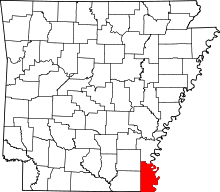 | |
| Unincorporated communities | ||
| Ghost town | ||
This article is issued from
Wikipedia.
The text is licensed under Creative Commons - Attribution - Sharealike.
Additional terms may apply for the media files.