Eudora, Arkansas
| Eudora, Arkansas | |
|---|---|
| City | |
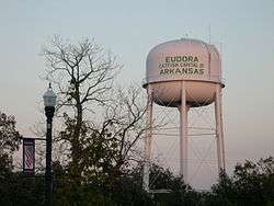 Eudora - Catfish Capital of Arkansas | |
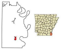 Location of Eudora in Chicot County, Arkansas. | |
| Coordinates: 33°6′53″N 91°15′46″W / 33.11472°N 91.26278°WCoordinates: 33°6′53″N 91°15′46″W / 33.11472°N 91.26278°W | |
| Country | United States |
| State | Arkansas |
| County | Chicot |
| Government | |
| • Mayor | Steven Tisdale |
| Area[1] | |
| • Total | 3.09 sq mi (8.01 km2) |
| • Land | 3.09 sq mi (8.01 km2) |
| • Water | 0.00 sq mi (0.00 km2) |
| Elevation | 135 ft (41 m) |
| Population (2010) | |
| • Total | 2,269 |
| • Estimate (2017)[2] | 2,005 |
| • Density | 648.24/sq mi (250.29/km2) |
| Time zone | UTC-6 (Central (CST)) |
| • Summer (DST) | UTC-5 (CDT) |
| ZIP code | 71640 |
| Area code(s) | 870 |
| FIPS code | 05-22180 |
| GNIS feature ID | 0057731 |
| Website |
cityofeudora |
Eudora is a city in Chicot County, Arkansas, United States. The population was 2,269 at the 2010 census,[3] down from 2,819 in 2000.
Geography
Eudora is located in southern Chicot County at 33°6′53″N 91°15′46″W / 33.11472°N 91.26278°W (33.114608, -91.262653).[4] U.S. Route 65 passes through the city, leading north 17 miles (27 km) to Lake Village, the Chicot County seat, northeast (via U.S. Route 82) 29 miles (47 km) to Greenville, Mississippi, and south 24 miles (39 km) to Lake Providence, Louisiana. Grand Lake, a former channel of the Mississippi River, is 4 miles (6 km) to the southeast.
According to the United States Census Bureau, Eudora has a total area of 3.1 square miles (7.9 km2), all land.[3]
Demographics
| Historical population | |||
|---|---|---|---|
| Census | Pop. | %± | |
| 1910 | 606 | — | |
| 1920 | 1,197 | 97.5% | |
| 1930 | 2,020 | 68.8% | |
| 1940 | 1,808 | −10.5% | |
| 1950 | 3,072 | 69.9% | |
| 1960 | 3,598 | 17.1% | |
| 1970 | 3,687 | 2.5% | |
| 1980 | 3,840 | 4.1% | |
| 1990 | 3,155 | −17.8% | |
| 2000 | 2,819 | −10.6% | |
| 2010 | 2,269 | −19.5% | |
| Est. 2017 | 2,005 | [2] | −11.6% |
| U.S. Decennial Census[5] 2014 Estimate[6] | |||
As of the 2010 United States Census, there were 2,269 people residing in the city. The racial makeup of the city was 89.3% Black, 9.1% White, 0.4% Native American, <0.1% Asian and 0.2% from two or more races. 1.0% were Hispanic or Latino of any race.
As of the census[7] of 2000, there were 2,819 people, 1,047 households, and 731 families residing in the city. The population density was 918.2 people per square mile (354.5/km²). There were 1,163 housing units at an average density of 378.8 per square mile (146.3/km²). The racial makeup of the city was 13.94% White, 84.50% Black or African American, 0.04% Native American, 0.18% Asian, 0.46% from other races, and 0.89% from two or more races. 1.38% of the population were Hispanic or Latino of any race.
There were 1,047 households out of which 34.9% had children under the age of 18 living with them, 30.5% were married couples living together, 34.7% had a female householder with no husband present, and 30.1% were non-families. 26.6% of all households were made up of individuals and 14.2% had someone living alone who was 65 years of age or older. The average household size was 2.69 and the average family size was 3.24.
In the city, the population was spread out with 32.4% under the age of 18, 9.4% from 18 to 24, 23.7% from 25 to 44, 20.0% from 45 to 64, and 14.6% who were 65 years of age or older. The median age was 33 years. For every 100 females, there were 80.2 males. For every 100 females age 18 and over, there were 68.9 males. The median income for a household in the city was $17,857, and the median income for a family was $19,840. Males had a median income of $20,729 versus $15,262 for females. The per capita income for the city was $9,437. About 34.6% of families and 36.5% of the population were below the poverty line, including 43.3% of those under age 18 and 30.0% of those age 65 or over.
Eudora has one grocery store, two dollar stores, and a factory that is the county's largest employer.
Climate
The climate in this area is characterized by hot, humid summers and generally mild to cool winters. According to the Köppen Climate Classification system, Eudora has a humid subtropical climate, abbreviated "Cfa" on climate maps.[8]
Culture
In 1970 Tony Joe White released a song on his self-titled album entitled "They Caught the Devil and Put Him in Jail in Eudora, Arkansas."
Education
The Lakeside School District operates public schools. On February 13, 2006, the Eudora School District consolidated into the Lakeside district.[9]
Notable people
- Charley Barnes - NFL end, born in Eudora
- Frank Burgess - U.S. Federal Judge, United States District Court for the Western District of Washington, born in Eudora
- Camille Keaton - actress
References
- ↑ "2017 U.S. Gazetteer Files". United States Census Bureau. Retrieved Aug 22, 2018.
- 1 2 "Population and Housing Unit Estimates". Retrieved March 24, 2018.
- 1 2 "Geographic Identifiers: 2010 Demographic Profile Data (G001): Eudora city, Arkansas". U.S. Census Bureau, American Factfinder. Retrieved June 16, 2014.
- ↑ "US Gazetteer files: 2010, 2000, and 1990". United States Census Bureau. 2011-02-12. Retrieved 2011-04-23.
- ↑ "Census of Population and Housing". Census.gov. Archived from the original on May 12, 2015. Retrieved June 4, 2015.
- ↑ "Annual Estimates of the Resident Population for Incorporated Places: April 1, 2010 to July 1, 2014". Retrieved June 4, 2015.
- ↑ "American FactFinder". United States Census Bureau. Archived from the original on 2013-09-11. Retrieved 2008-01-31.
- ↑ Climate Summary for Eudora, Arkansas
- ↑ "ConsolidationAnnex_from_1983.xls." Arkansas Department of Education. Retrieved on October 13, 2017.
External links
Municipalities and communities of Chicot County, Arkansas, United States | ||
|---|---|---|
| Cities | 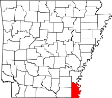 | |
| Unincorporated communities | ||
| Ghost town | ||