Dunnockshaw
| Dunnockshaw | |
|---|---|
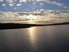 Sunset at Clowbridge Reservoir | |
 Dunnockshaw Shown within Burnley Borough  Dunnockshaw Dunnockshaw shown within Lancashire | |
| Area | 1.02 sq mi (2.6 km2) [1] |
| Population | 185 (2011)[1] |
| • Density | 181/sq mi (70/km2) |
| OS grid reference | SD821280 |
| Civil parish |
|
| District | |
| Shire county | |
| Region | |
| Country | England |
| Sovereign state | United Kingdom |
| Post town | BURNLEY |
| Postcode district | BB11 |
| Dialling code | 01282 |
| Police | Lancashire |
| Fire | Lancashire |
| Ambulance | North West |
| EU Parliament | North West England |
| UK Parliament | |
Dunnockshaw or Dunnockshaw and Clowbridge is a civil parish in the borough of Burnley, in Lancashire, England. The parish is situated between Burnley and Rawtenstall.
According to the United Kingdom Census 2011, the parish has a population of 185,[1] a decrease from 212 in the 2001 census.[2]
It contains the hamlets of Clowbridge and Dunnockshaw, both located on the A682 road. Clowbridge Reservoir is situated in the east of parish on the boundary with Rossendale. The reservoir, operated by United Utilities, is a used as a location for water sports. It was built in 1866 resulting in the de-population of the village of Gambleside (on the Rossendale side).
The parish adjoins the Burnley parishes of Hapton and Habergham Eaves and the Borough of Rossendale.
Dunnockshaw was once a township in the ancient parish of Whalley. This became a civil parish in 1866, forming part of the Burnley Rural District from 1894. The Clowbridge area, previously part of Hapton,[lower-alpha 1] transferred to Dunnockshaw but a detached area of the old township moved to Hapton in 1935.[4]
During World War II a Starfish site bombing decoy was constructed on Hameldon hill near Heights Farm, part of a network designed to protect Accrington.[5] Its site is protected as a Scheduled monument.[6]
Media gallery
 Clowbridge
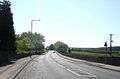 A682 Burnley Road
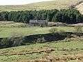 New Laithe farm
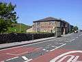
 Oak Mill, Dunnockshaw
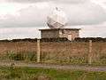 Met Office north-west England weather radar on Hambledon Hill
See also
References
Notes
- ↑ The old township boundary with Hapton broadly followed Limy Water and is today beneath Clowbridge Reservoir.[3]
Citations
- 1 2 3 UK Census (2011). "Local Area Report – Dunnockshaw Parish (1170214983)". Nomis. Office for National Statistics. Retrieved 10 February 2018.
- ↑ Office for National Statistics : Census 2001 : Parish Headcounts : Burnley Retrieved 4 February 2010
- ↑ Lancashire and Furness (Map) (1st ed.). 1 : 10,560. County Series. Ordnance Survey. 1848.
- ↑ "Dunnockshaw Tn/CP through time". visionofbritain.org.uk. GB Historical GIS / University of Portsmouth. Retrieved 27 June 2015.
- ↑ Historic England. "STARFISH BOMBING DECOY SF35E (1360177)". PastScape. Retrieved 31 July 2015.
- ↑
External links
| Wikimedia Commons has media related to Dunnockshaw. |
- Map of Dunnockshaw and Clowbridge parish boundary Today - Lancashire County Council
- Map of Dunnockshaw parish boundary circa 1850
- Dunnockshaw Township - British History Online
- Clowbridge Reservoir & Dunnockshaw Community Woodland at United Utilities Website
Geography of the Borough of Burnley | |||||||
|---|---|---|---|---|---|---|---|
| Towns | 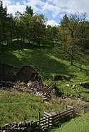 | ||||||
| Villages & suburbs | |||||||
| Parishes | |||||||
| Topography |
| ||||||