Hachiōji Station
JC22 JH32 Hachiōji Station 八王子駅 | |
|---|---|
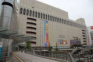 Hachiōji Station north side, April 2014 | |
| Location |
1 Asahichō, Hachiōji-shi, Tokyo Japan |
| Operated by |
|
| Line(s) | |
| Platforms | 3 island platforms |
| History | |
| Opened | 11 August 1889 |
| Traffic | |
| Passengers (FY2014) | 84,739 daily |
Hachiōji Station (八王子駅 Hachiōji-eki) is a railway station in the city of Hachiōji, Tokyo, Japan, operated by East Japan Railway Company (JR East). It opened on August 11, 1889.[1]
Lines
The Chūō Main Line passes through Hachiōji Station, which is 47.4 kilometers from the terminus of the line at Tokyo Station. The Yokohama Line (to Higashi-Kanagawa) and Hachikō Line (to Komagawa) terminate here. The station is also served by some Sagami Line trains via the Yokohama Line, although the Sagami Line itself does not actually reach Hachiōji.
Keiō Hachiōji Station on the Keio Line is located about 400 metres northeast from here.
Station layout
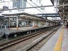
The station consists of three island platforms serving four tracks with the platforms connected the elevated station building. The station has a "Midori no Madoguchi" staffed ticket office.
Platforms
| 1 | ■ Hachiko Line/Kawagoe Line | for Haijima, Komagawa, and Kawagoe |
| 2 | JC Chūō Line (Rapid) | for Tachikawa, Shinjuku, and Tokyo |
| 3 | ■ | (Used by some up Chuo Line services starting at this station) |
| 4 | JC■ Chūō Main Line | for Takao, Kōfu, and Matsumoto |
| 5-6 | JH Yokohama Line | for Hashimoto, Machida, Higashi-Kanagawa, Sakuragichō and Ōfuna ■ Sagami Line for Hashimoto, Ebina, and Chigasaki |
Adjacent stations
| « | Service | » | ||
|---|---|---|---|---|
| Chūō Line (Rapid) JC22 | ||||
| Tachikawa JC19 | Chūō Liner | Takao JC24 | ||
| Tachikawa JC19 | Commuter Special Rapid | Takao JC24 | ||
| Toyoda JC21 | Chūō Special Rapid | Nishi-Hachiōji JC23 | ||
| Toyoda JC21 | Commuter Rapid | Nishi-Hachiōji JC23 | ||
| Toyoda JC21 | Musashino Line Musashino | Terminus | ||
| Toyoda JC21 | Rapid | Nishi-Hachiōji JC23 | ||
| Toyoda JC21 | Local[Note 1] | Nishi-Hachiōji JC23 | ||
| Chūō Main Line JC22 | ||||
| Tachikawa JC19 | Azusa, Super Azusa | Ōtsuki Kōfu | ||
| Tachikawa JC19 | Kaiji | Ōtsuki | ||
| Tachikawa JC19 | Narita Express | Takao JC24 | ||
| Toyoda JC21 | Local | Nishi-Hachiōji JC23 | ||
| Yokohama Line JH32 | ||||
| Katakura JH31 | Rapid | Terminus | ||
| Katakura JH31 | Local | Terminus | ||
| Hachikō Line | ||||
| Terminus | Local | Kita-Hachiōji | ||
- ↑ Early morning and late night only
History
Hachiōji Station opened on 11 August 1889.[2] With the privatization of Japanese National Railways (JNR) on 1 April 1987, the station came under the control of JR East.
Passenger statistics
In fiscal 2014, the station was used by an average of 84,739 passengers daily (boarding passengers only), making it the fiftieth-busiest station operated by JR East.[3]
The daily passenger figures (boarding passengers only) in previous years are as shown below.
| Fiscal year | Daily average |
|---|---|
| 2000 | 80,697[4] |
| 2005 | 80,755[5] |
| 2010 | 80,219[6] |
| 2011 | 81,474[7] |
| 2012 | 82,521[8] |
| 2013 | 85,191[9] |
See also
References
- ↑ JR East Hachiōji Station information Retrieved on 21 August 2008.(in Japanese)
- ↑ 日本国有鉄道停車場一覧 [JNR Station Directory]. Japan: Japanese National Railways. 1985. p. 53. ISBN 4-533-00503-9.
- ↑ 各駅の乗車人員 (2014年度) [Station passenger figures (Fiscal 2014)] (in Japanese). Japan: East Japan Railway Company. 2015. Retrieved 5 October 2015.
- ↑ 各駅の乗車人員 (2000年度) [Station passenger figures (Fiscal 2000)] (in Japanese). Japan: East Japan Railway Company. Retrieved 24 September 2014.
- ↑ 各駅の乗車人員 (2005年度) [Station passenger figures (Fiscal 2005)] (in Japanese). Japan: East Japan Railway Company. Retrieved 24 September 2014.
- ↑ 各駅の乗車人員 (2010年度) [Station passenger figures (Fiscal 2010)] (in Japanese). Japan: East Japan Railway Company. Retrieved 24 September 2014.
- ↑ 各駅の乗車人員 (2011年度) [Station passenger figures (Fiscal 2011)] (in Japanese). Japan: East Japan Railway Company. Retrieved 24 September 2014.
- ↑ 各駅の乗車人員 (2012年度) [Station passenger figures (Fiscal 2012)] (in Japanese). Japan: East Japan Railway Company. Retrieved 24 September 2014.
- ↑ 各駅の乗車人員 (2013年度) [Station passenger figures (Fiscal 2013)] (in Japanese). Japan: East Japan Railway Company. Retrieved 24 September 2014.
External links
| Wikimedia Commons has media related to Hachiōji Station. |
- Hachiōji Station information (JR East) (in Japanese)
Coordinates: 35°39′20″N 139°20′20″E / 35.65556°N 139.33889°E
| |||||||||||||||||||||||||||||||||||||||||||||||||||||||