Gwangju Metro
|
| |||
 | |||
| Overview | |||
|---|---|---|---|
| Locale | Gwangju, South Korea | ||
| Transit type | Rapid transit | ||
| Number of lines | 1 | ||
| Number of stations | 20 | ||
| Operation | |||
| Began operation | 28 April 2004 | ||
| Operator(s) | Gwangju Metropolitan Rapid Transit Corporation | ||
| Technical | |||
| System length | 20.1 km (12.5 mi) | ||
| Track gauge | 1,435 mm (4 ft 8 1⁄2 in) | ||
| |||
| Gwangju Metro | |
| Hangul | 광주도시철도 |
|---|---|
| Hanja | 光州都市鐵道 |
| Revised Romanization | Gwangju Dosi Cheoldo |
| McCune–Reischauer | Kwangchu Tosi Ch'ŏldo |
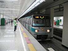
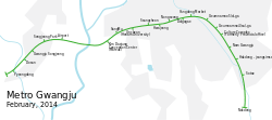
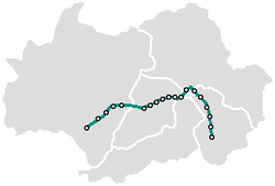
Gwangju Metro (Hangul: 광주 도시철도; Hanja: 光州都市鐵道) is the rapid transit system of Gwangju, South Korea, operated by the Gwangju Metropolitan Rapid Transit Corporation (GRTC, or Gwangju Metro). The subway network first opened in 2004 with 14 stations. The Gwangju Metro consists of one line, serving 20 operational stations, and operating on 20.1 kilometres (12.5 mi) of route. It cross 2 rivers. One is Yeongsan river, other is Hwangryong river. Sotae Station to Nokdong Station and Pyeongdong Station to Dosang Station is overground course.
History
- Apr 28, 2004 : Line 1 partially opened ( Nokdong <--> Sangmu )
- Apr 11, 2008 : Line 1 fully opened ( Nokdong <-> Pyeongdong )
Lines
English |
Hangul |
in km | |||
| 1 | 1호선 | Nokdong | Pyeongdong | 20 | 20.6 |
Line 1
As of 2012 Line 1 consists of twenty stations. The section between Sotae and Nokdong operates as a separate shuttle.[1]
Expansions and plans
Plan to extend Line 1
The Gwangju City Government has a plan to extend the current Line 1 southward to Hwasun and northward to Naju. Recently, the Presidential Committee on Balanced National Development promised to include the Line 1 extension in its '5+2 extensive economic zone' project.[2]
Plan of lines
The original plan of Line 2 was a circle type, but recently the Gwangju City Government suggested to consider a so-called 'South-North type' as well. Now the Gwangju City Government is holding a public hearing.[3]
- Route of Circle Line (Plan 1) : Baekyoon-gwangjang (백운광장 a.k.a. white cloud square) - Namgwangju Station (남광주역) - Gwangju Station (광주역) - Gwangju Bus Terminal (터미널) - Market (시장) - Sangmu (상무) - Baegun-gwangjang (백운광장) - Hyocheon Station (효천역) (27.4 km)
- Route of South-North Line (Plan 2) : Hyocheon Station (효천역) - Baekyoon-gwangjang (백운광장 a.k.a. white cloud square) - Namgwangju Station (남광주역) - Chosun University (조선대) - Gwangju Station (광주역) - Chonnam National University (전남대) - Ilgongno (일곡로) - Bonchon-industrial park (본촌공업단지) - Cheomdan-area (첨단지구) (24.58 km)
See also
References
- ↑ "Gwangju", UrbanRail.Net, archived from the original on 2012-04-26, retrieved 2012-04-12
- ↑ "Seoul Newspaper:Presidential Committee on Balanced National Development accepted Gwangju's new proposal of 5+2 project". Retrieved 2009-02-11.
- ↑ "Gwangju Subway Line 2, two alternatives". Retrieved 2009-02-06.
External links
| Wikimedia Commons has media related to Gwangju Subway. |
- Official website (in English)
| Seoul Capital Area |
| ||||||||||
|---|---|---|---|---|---|---|---|---|---|---|---|
| Busan |
| ||||||||||
| Daegu | |||||||||||
| Daejeon | |||||||||||
| Gwangju | |||||||||||