Gwangju
| Gwangju 광주시 | |||
|---|---|---|---|
| Metropolitan City | |||
| Gwangju Metropolitan City | |||
| transcription(s) | |||
| • Hangul | 광주광역시 | ||
| • Hanja | 光州廣域市 | ||
| • Revised Romanization | Gwangju-gwangyeoksi | ||
| • McCune-Reischauer | Kwangju-kwangyŏksi | ||
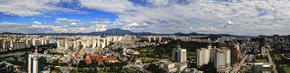 Downtown Gwangju from city hall | |||
| |||
 Map of South Korea with Gwangju highlighted | |||
| Country |
| ||
| Region | Honam | ||
| Districts | 5 | ||
| Government | |||
| • Type | Mayor–Council | ||
| • Mayor | Lee Yong-seop (Democratic) | ||
| • Body | Gwangju Metropolitan Council | ||
| Area | |||
| • Total | 501.24 km2 (193.53 sq mi) | ||
| Population (October, 2014[1]) | |||
| • Total | 1,477,780 | ||
| • Density | 2,900/km2 (7,600/sq mi) | ||
| • Dialect | Jeolla | ||
| ISO 3166 code | KR-29 | ||
| Flower | Royal Azalea | ||
| Tree | Ginkgo | ||
| Bird | Dove | ||
| GDP | US$ 36.7 billion [2] | ||
| GDP per capita | US$24,520 [2] | ||
| Website | gwangju.go.kr | ||


Gwangju[lower-alpha 1] (Korean pronunciation: [kwaŋ.dʑu]) is the sixth largest city in South Korea. It is a designated metropolitan city under the direct control of the central government's Home Minister. The city was also the capital of South Jeolla Province until the provincial office moved to the southern village of Namak in Muan County in 2005.
Its name is composed of the words Gwang (Hangul: 광; Hanja: 光) meaning "light" and Ju (주; 州) meaning "province." Gwangju was historically recorded as Muju (무주; 武州), in which "Silla merged all of the land to establish the provinces of Gwangji, Ungju, Jeonju, Muju and various counties, plus the southern boundary of Goguryeo and the ancient territories of Silla" in the Samguk Sagi.[4] Located in the heart of the agricultural Jeolla region, the city is also famous for its rich and diverse cuisine.
History
The city was established in 57 BC. It was one of the administrative centres of Baekje during the Three Kingdoms Period.[5]
In 1929, during the period of Imperial Japanese rule, a confrontation between Korean and Japanese students in the city turned into a regional demonstration, which culminated in one of the major nationwide uprisings against Imperial Japanese cruelty during the colonial period.
Modern industry was established in Gwangju with the construction of a railway to Seoul. Some of the industries that took hold include cotton textiles, rice mills and breweries. Construction of a designated industrial zone in 1967 encouraged growth in industry, especially in the sectors linked to the automobile industry.
In May 1980, peaceful demonstrations took place in Gwangju against Chun Doo-hwan, leader of the military coup d'état of December 12, 1979. The demonstrations were suppressed by military forces, including elite units of the Special Operations Command. The situation escalated after a violent crackdown, resulting in the Gwangju Uprising, where civilians raided armories and armed themselves. By the time the uprising was suppressed 9 days later, many hundreds of civilians and several police forces / soldiers were dead. After civilian rule was reinstated in 1987, a national cemetery was established, honouring the victims of the incident.[6]
In 1986, Gwangju separated from Jeollanam-do to become a Directly Governed City (Jikhalsi), and then became a Metropolitan City (Gwangyeoksi) in 1995.[5]
Due to a variety of factors, including the ancient rivalry between Baekje and Silla, as well as the biased priority given to the Gyeongsang region by political leaders in the 2nd half of the 20th century, Gwangju has a long history of voting for left-leaning politicians and is the main stronghold for the liberal Democratic Party of Korea along with its predecessors, as well as the progressive Justice Party.
Arts, culture, cuisine/food, cars and democracy are some of the keywords that can represent Gwangju.
Administrative divisions
Gwangju is divided into 5 districts ("Gu").
| Map | Name | Korean | Hanja | |
|---|---|---|---|---|
| ||||
| Districts | ||||
| Buk District | 북구 | 北區 | ||
| Dong District | 동구 | 東區 | ||
| Gwangsan District | 광산구 | 光山區 | ||
| Nam District | 남구 | 南區 | ||
| Seo District | 서구 | 西區 | ||

Religion
Religion in Gwangju (2005)[7]
According to the census of 2005, of the people of Gwangju 33% follow Christianity (20% Protestantism and 13% Catholicism) and 14% follow Buddhism.[7] 53% of the population is mostly not religious or follow Muism and other indigenous religions.
Population
The population model of Gwangju is as follows;[8]
| Year | Population |
|---|---|
| 1960 | 409,283 |
| 1966 | 532,235 |
| 1970 | 622,755 |
| 1975 | 737,283 |
| 1980 | 856,545 |
| 1985 | 1,042,508 |
| 1990 | 1,139,003 |
| 1995 | 1,257,636 |
| 2000 | 1,352,797 |
| 2005 | 1,417,716 |
| 2010 | 1,475,745 |
| 2016 | 1,500,621 |
Climate
| Climate data for Gwangju (1981–2010, extremes 1938–present) | |||||||||||||
|---|---|---|---|---|---|---|---|---|---|---|---|---|---|
| Month | Jan | Feb | Mar | Apr | May | Jun | Jul | Aug | Sep | Oct | Nov | Dec | Year |
| Record high °C (°F) | 18.8 (65.8) |
21.1 (70) |
26.8 (80.2) |
29.1 (84.4) |
33.9 (93) |
36.7 (98.1) |
38.5 (101.3) |
38.5 (101.3) |
34.4 (93.9) |
31.1 (88) |
27.1 (80.8) |
19.7 (67.5) |
38.5 (101.3) |
| Average high °C (°F) | 5.3 (41.5) |
7.8 (46) |
13.0 (55.4) |
19.6 (67.3) |
24.3 (75.7) |
27.5 (81.5) |
29.6 (85.3) |
30.7 (87.3) |
26.9 (80.4) |
21.8 (71.2) |
14.6 (58.3) |
8.1 (46.6) |
19.1 (66.4) |
| Daily mean °C (°F) | 0.6 (33.1) |
2.5 (36.5) |
7.0 (44.6) |
13.2 (55.8) |
18.3 (64.9) |
22.4 (72.3) |
25.6 (78.1) |
26.2 (79.2) |
21.9 (71.4) |
15.8 (60.4) |
9.1 (48.4) |
3.1 (37.6) |
13.8 (56.8) |
| Average low °C (°F) | −3.1 (26.4) |
−1.8 (28.8) |
2.1 (35.8) |
7.5 (45.5) |
13.0 (55.4) |
18.2 (64.8) |
22.5 (72.5) |
22.8 (73) |
17.8 (64) |
10.9 (51.6) |
4.5 (40.1) |
−0.9 (30.4) |
9.5 (49.1) |
| Record low °C (°F) | −19.4 (−2.9) |
−17.7 (0.1) |
−10.7 (12.7) |
−4.5 (23.9) |
1.4 (34.5) |
7.2 (45) |
14.9 (58.8) |
12.6 (54.7) |
5.6 (42.1) |
−2.7 (27.1) |
−7.2 (19) |
−13.7 (7.3) |
−19.4 (−2.9) |
| Average precipitation mm (inches) | 37.1 (1.461) |
47.9 (1.886) |
60.8 (2.394) |
80.7 (3.177) |
96.6 (3.803) |
181.5 (7.146) |
308.9 (12.161) |
297.8 (11.724) |
150.5 (5.925) |
46.8 (1.843) |
48.8 (1.921) |
33.5 (1.319) |
1,391 (54.764) |
| Average precipitation days (≥ 0.1 mm) | 11.0 | 9.0 | 9.5 | 8.9 | 9.3 | 10.7 | 15.5 | 14.9 | 9.8 | 6.8 | 9.0 | 10.0 | 124.4 |
| Average snowy days | 11.1 | 7.1 | 2.8 | 0.2 | 0.0 | 0.0 | 0.0 | 0.0 | 0.0 | 0.0 | 1.5 | 8.1 | 31.0 |
| Average relative humidity (%) | 67.7 | 65.2 | 62.9 | 61.9 | 66.4 | 72.8 | 80.0 | 78.1 | 74.3 | 68.4 | 68.1 | 68.8 | 69.5 |
| Mean monthly sunshine hours | 159.9 | 164.6 | 192.0 | 213.0 | 222.8 | 169.2 | 145.4 | 172.6 | 172.3 | 205.2 | 163.6 | 155.9 | 2,136.3 |
| Percent possible sunshine | 51.1 | 53.4 | 51.8 | 54.3 | 51.3 | 39.0 | 32.9 | 41.4 | 46.3 | 58.5 | 52.7 | 51.1 | 48.0 |
| Source: Korea Meteorological Administration[9][10][11] (percent sunshine and snowy days)[12] | |||||||||||||
Education
Chonnam National University, Gwangju Institute of Science and Technology, Gwangju Education University are public universities in Gwangju.
Honam University, Gwangju University, Gwangshin University, Gwangju Women's University, Nambu University, Chosun University, and Honam Christian University are private universities.
Gwangju Health University is a private community college offering associate degrees in humanities and social sciences, healthcare sciences, and a bachelor's degree in nursing.
Gwangju has 593 schools, consisting of 234 kindergartens, 145 elementary schools, 84 middle schools, 65 high schools, 1 science high school,[13] 7 junior colleges, 9 universities, 38 graduate schools, and 11 others (as of 1 May 2009) with a total of 406,669 students, or 28.5% of the total city population. The average number of students per household is 0.8.
Transportation
The city is served by the Gwangju Subway. An extension was completed in April 2008 with another due for completion in 2012. There are two KTX (high-speed rail) stations in the city: Gwangju Station and Gwangju Songjeong Station. Gwangju Songjeong station connects to the Gwangju Subway and local bus system. Now the Songjeong station is mainly used.
Gwangju has an extensive system of public buses that traverse the city.[14] Bus stops and buses themselves contain stop information in Korean and in English. Local buses, but not the subway or KTX, connect to the intercity Gwangju Bus Terminal known as U-Square.[15]
Gwangju public transport fares can be paid with cash, some Korean bank cards, or via reloadable public transport cards, or small accessories attachable to phones or keychains, such as Hanpay, T-Money, and CashBee which are available at convenience stores.[16] A small discount is provided when using non-cash fare.[16] Reduced fares are available for youth (13 to 18) and children (7 to 12).[16] As of August 1, 2016 Gwangju transportation fares, in KRW, are:[17]
| Adult | Adult | Youth | Youth | Child | Child | |
|---|---|---|---|---|---|---|
| Cash | Non-cash (Card) | Cash | Non-cash (Card) | Cash | Non-cash (Card) | |
| Regular Buses | 1,400 | 1,250 | 1,000 | 800 | 500 | 400 |
| Express Buses | 1,800 | 1,700 | 1,500 | 1,350 | 1,000 | 850 |
Transfers can be made for free between local bus routes and the subway when using non-cash fare, provided that the user taps off when changing between modes of transportation, is going in the same direction, and, in the case of bus-to-bus transfers, is taking a bus with a different route number.[16][18] Free transfers between buses can be taken within one hour of tapping off; transfers from bus to subway must occur within half an hour.[19]
Most local taxis accept local and foreign cards in addition to cash and public transportation cards such as Hanpay.[20]
Gwangju is also served by the Gwangju Airport.
Tourism
- Gwangju Asia Culture Center – The Asia Culture Center (also known as the ACC or Asian Culture Complex) is a facility located in downtown Gwangju designed to celebrate and explore Gwangju's artistic and democratic culture and history as well as provide space to host exhibits, experiences, and events from international artists. It is built primarily below street level, though its design incorporates large amounts of natural lighting. There are five facilities: ACC Exchange, ACC Theater, ACC Creation, ACC Archive & Research, and ACC Children.[21]
- Facilities
- ACC Exchange includes May 18 Memorial Halls 1, 2, 3, 4, and 5, the Ticket Office and Visitor Centre, and the Exchange and Cooperation centre. It is the only facility located on street level and incorporates buildings that survived the May 18th democratic uprising. The May 18th Democracy Square and a public use plaza are also located on street level. ACC Exchange has no charge for admission to the May 18 Memorial.
- ACC Archive and Research, located in basement levels one through four includes a lecture room, conference hall, the Asian Culture Research Institute, Asian Culture Academy, Library Park, a Theater, a Reading Room, the Asian Culture Resource Archives, and the Culture Archive Storage. The Archives are free to the public.
- ACC Creation, located in basement levels two through four contains six spaces for exhibits and installations and the ACT Studio. General admission to the exhibits is 20,000 won, 14,000 won for students, and 5,000 won for elementary aged students.
- ACC Theater, located in basement levels three and four, includes two theaters with convertible seating, one of which can open to connect with the Outdoor Space to form an Outdoor Theater with open-air seating. Pricing for theater events varies.
- ACC Children, located in basement levels one and two, comprises the Culture Adventure centre, Children's Content R&D Center, the Play Culture, Play Kids, Playhouse, and Play Library centres, a Cafeteria and Lunch Lounge, and a Children's Event Hall.[22] Prices vary between areas of ACC Children.
- Facilities
- Gwangju Biennale – This is a modern art festival that is held every two years. It was first launched in 1995. The Gwangju Biennale Exhibition Hall is located at the Jung-oe Park Culture Center and the Science Center.
- Gwangju Culture & Art Center – The Center regularly hosts events.Gwangju Culture & Art Center Official Website
- Gwangju Hyanggyo (Confucian School) – Gwangju Hyanggyo is located in the Gwangju Park in Sa-dong. There are traditional houses here estimated as built during the 1st year of the Joseon Dynasty in 1392. This school continues to hold memorial ceremonies for Confucius twice a year. Admission is free. More about Gwangju Hyanggyo
- Gwangju National Museum – The museum houses a permanent collection of historical art and cultural relics that date back to the old Joseon and Goryeo periods of Korean history. The museum also organizes exhibitions and cultural learning activities that are open to the public.
- Gwangju 5.18Road – 5.18 Road is the course about the Democratisation Movement in 1980. The courses include the historical places. More about 5.18Road
- May 18th National Cemetery
- 8 Scenes and 5 Flavours of Gwangju
- Food streets
- Gwangju has numerous designated Food Streets where multiple restaurants serving dishes renowned to Gwangju can be found. These include Mudeungsan Boribap Street (a meal of barley with a variety of side dishes),[23] Duck Cook Street (oritang, a duck stew, and grilled duck),[24] Folk Tteokgalbi Street[25] (a meal of grilled minced pork or beef patties eaten wrapped in lettuce and served with ox bone soup and a variety of side dishes) and Kotgejang Baekban Street[26] (a meal of crabs preserved in soy sauce served with a variety of side dishes).
Sport and culture
- It is the home of KIA Tigers of the Korea Professional Baseball League (KBO)
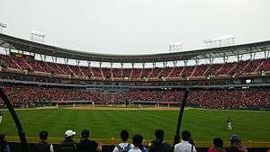 Gwangju-Kia Champions Field, home field of Kia Tigers.
 - 2002 FIFA World Cup – Gwangju World Cup Stadium was one of the venues used for the World Cup, and was where the South Korea national football team advanced to the semi-finals for the first time in its history, by defeating Spain.
- It is the home of Gwangju FC of the K League[27]
- Universiade – It was the venue for the 2015 Summer Universiade games.
- The 3rd Asia Song Festival, organised by Korea Foundation for International Culture Exchange, in 2006, was held at the Gwangju World Cup Stadium.[28]
- The International Design Alliance (IDA) appointed Gwangju as the host destination of the 2015 IDA Congress.
- Festivals are held in Gwangju (ko:광주광역시의 축제 목록)
- 2019 FINA World Aquatics Championships
- 2014 Gwangju ACE Fair (Asia Content & Entertainment Fair)[29]
Cityscape
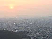
- Mudeungsan – It is a mountain which is a part of Mudeungsan National Park.[30]
International relations
Twin towns – Sister cities
|
Partnerships and Cooperations
Other forms of partnership and city friendship similar to the twin city programmes exist:
Notable people
- Literature
- Han Kang – Author of The Vegetarian and Human Acts
- Idol
- Lee Seung-hyun (stage name Seungri) – member of K-pop group Big Bang
- Jung Ho-seok (stage name J-Hope) – member of K-pop group BTS
- Jung Yunho (stage name U-Know) – member of K-pop group 東方神起 (TVXQ) / Tohoshinki / 동방신기 (Dong Bang Shin Ki)
- Seo Hye-lin (stage name Hyerin) – member of K-pop group EXID
- Lee Sung-jong – member of K-pop group Infinite
- Lee Min-hyuk – member of K-pop group Monsta X
- Chae Hyungwon - member of K-pop group Monsta X
- Im Changkyun - member of K-pop group Monsta X
- Bae Suzy – member of K-pop group Miss A
- Minzy (birth name Gong, Min-ji) – member of K-pop group 2NE1
- Kim Yu-bin – member of Wonder Girls
- Hong Jin-young – a trot singer
See also
- About Gwangju
- General lists
Notes
References
Citations
- ↑ "Archived copy". Archived from the original on 29 November 2014. Retrieved 1 October 2015.
- 1 2 "Global city GDP 2014". Brookings Institution. Archived from the original on 4 June 2013. Retrieved 18 November 2014.
- ↑ EB (1878), p. 390.
- ↑ "Origin and History of Gwangju". www.gwangju.go.kr (in Korean). Retrieved 2018-04-18.
- 1 2 "The History of Gwangju".
- ↑ "May 18th Democratic Uprising".
- 1 2 2005 Census – Religion Results Archived 4 September 2015 at the Wayback Machine.
- ↑ National Statistical Office of South Korea
- ↑ "평년값자료(1981–2010) 광주(156)" (in Korean). Korea Meteorological Administration. Retrieved 10 January 2017.
- ↑ "기후자료 극값(최대값) 전체년도 일최고기온 (℃) 최고순위, 광주(156)" (in Korean). Korea Meteorological Administration. Retrieved 10 January 2017.
- ↑ "기후자료 극값(최대값) 전체년도 일최저기온 (℃) 최고순위, 광주(156)" (in Korean). Korea Meteorological Administration. Retrieved 10 January 2017.
- ↑ "Climatological Normals of Korea" (PDF). Korea Meteorological Administration. 2011. p. 499 and 649. Archived from the original (PDF) on 7 December 2016. Retrieved 10 January 2017.
- ↑ Gwangju science academy
- ↑ "광주광역시 버스정보". bus.gjcity.net. Retrieved 2016-07-29.
- ↑ "U-Square (Gwangju Bus Terminal) (유스퀘어(광주종합버스터미널)) | Official Korea Tourism Organization". english.visitkorea.or.kr. Retrieved 2016-07-29.
- 1 2 3 4 "광주광역시 버스정보". bus.gjcity.net. Retrieved 2016-07-29.
- ↑ "광주광역시 버스정보". bus.gjcity.net. Retrieved 2016-07-29.
- ↑ "Gwangju Guide : Bus". Gwangju Guide. 11 June 2011. Archived from the original on 17 August 2016. Retrieved 29 July 2016.
- ↑ "쿄통카드/요금안내 광역대중교통확승제FAQ – Q.5".
- ↑ "Living in Gwangju : Transport". Gwangju Guide. Gwangju International Center. 8 January 2013. Archived from the original on 26 August 2016. Retrieved 29 July 2016.
- ↑ "Asia Culture Center". www.acc.go.kr. Retrieved 2016-07-29.
- ↑ "Asia Culture Center". www.acc.go.kr. Retrieved 2016-07-29.
- ↑ https://web.archive.org/web/20160910054814/http://utour.gwangju.go.kr/contents.do?S=S02&M=041101000000
- ↑ https://web.archive.org/web/20160807071139/http://utour.gwangju.go.kr/contents.do?S=S02&M=041102000000
- ↑ https://web.archive.org/web/20160807034556/http://utour.gwangju.go.kr/contents.do?S=S02&M=041103000000
- ↑ https://web.archive.org/web/20160807012127/http://utour.gwangju.go.kr/contents.do?S=S02&M=041104000000
- ↑ (in Korean) K-League news 4강 역사를 쓴 그곳, 광주 월드컵 경기장 Dream stadium of K-League Archived 16 February 2009 at the Wayback Machine.
- ↑ KOFICE 3rd Asia Song Festival Archived 29 August 2011 at the Wayback Machine. 22 September 2006. Retrieved 2011-10-12
- ↑ "2016 광주 ACE Fair". www.acefair.or.kr. Retrieved 2016-04-25.
- ↑ "Korea National Park". english.knps.or.kr. Retrieved 2016-04-25.
- ↑ Gwangju Sister Cities Archived 4 July 2014 at the Wayback Machine.
- ↑ Sister Cities Program. Sainternationalrelations.org. Retrieved on 2011-12-11.
- ↑ "Guangzhou Sister Cities[via WaybackMachine.com]". Guangzhou Foreign Affairs Office. Archived from the original on 24 October 2012. Retrieved 2013-07-21.
- ↑ http://www.pemkomedan.go.id/news_detail.php?id=106 Medan Menjalin Hubungan Kota Kembar Keempat Retrieved September 10, 2013 Archived 23 April 2007
- ↑ "MPSP sets sights on city status". The Star. 1 August 2016.
- ↑ Pessotto, Lorenzo. "International Affairs – Twinnings and Agreements". International Affairs Service in cooperation with Servizio Telematico Pubblico. City of Torino. Archived from the original on 2013-06-18. Retrieved 2013-08-06.
Bibliography
- "Corea", Encyclopædia Britannica, 9th ed., Vol. VI, New York: Charles Scribner's Sons, 1878, pp. 390–394 .
External links
| Wikimedia Commons has media related to Gwangju. |
| Wikivoyage has a travel guide for Gwangju. |
- Official website of Gwangju
- Gwangju News Online: the latest news and views about life around town
- The 18 May Memorial Foundation
- Gwangju :Official Site of Korea Tourism Org
- Gwangju International Center
- Gwangju Guidebook
- Gwangju Foreign Network – Radio Station in English for Gwangju
- Local events guide for Gwangju