Gum Tree, Kentucky
| Gum Tree | |
|---|---|
| Unincorporated community | |
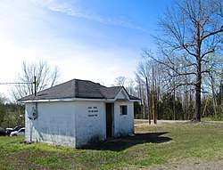 Gum Tree Voting House | |
 Gum Tree Location within the state of Kentucky  Gum Tree Gum Tree (the US) | |
| Coordinates: 36°43′27″N 85°49′10″W / 36.72417°N 85.81944°WCoordinates: 36°43′27″N 85°49′10″W / 36.72417°N 85.81944°W | |
| Country | United States |
| State | Kentucky |
| County | Monroe |
| Elevation | 938 ft (286 m) |
| Time zone | UTC-6 (Central (CST)) |
| • Summer (DST) | UTC-5 (CDT) |
| ZIP codes | 42167 |
| GNIS feature ID | 508148[1] |
Gum Tree is an unincorporated community located in Monroe County, Kentucky, United States. It is concentrated around the intersection of Kentucky Route 678, Kentucky Route 870, and Kentucky Route 1366, west of Tompkinsville and north of Gamaliel. Gum Tree is home to one of Monroe County's voting precincts, which had over 900 registered voters as of 2014.[2]
References
- ↑ U.S. Geological Survey Geographic Names Information System: Gum Tree, Kentucky
- ↑ Voter Registration Statistics Report, Commonwealth of Kentucky, State Board of Elections, 20 May 2014.
Municipalities and communities of Monroe County, Kentucky, United States | ||
|---|---|---|
| Cities |  | |
| Unincorporated communities | ||
This article is issued from
Wikipedia.
The text is licensed under Creative Commons - Attribution - Sharealike.
Additional terms may apply for the media files.