Bugtussle, Kentucky
| Bugtussle | |
|---|---|
| Unincorporated community | |
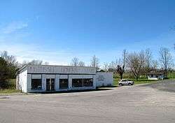 The old Bugtussle General Store | |
 Bugtussle Location within the state of Kentucky  Bugtussle Bugtussle (the US) | |
| Coordinates: 36°37′33″N 85°52′33″W / 36.62583°N 85.87583°WCoordinates: 36°37′33″N 85°52′33″W / 36.62583°N 85.87583°W | |
| Country | United States |
| State | Kentucky |
| County | Monroe |
| Elevation | 866 ft (264 m) |
| Time zone | UTC-6 (Central (CST)) |
| • Summer (DST) | UTC-5 (CDT) |
| GNIS feature ID | 507615[1] |
Bugtussle is an unincorporated community in Monroe County, Kentucky, United States. It is located in the southern part of the county, immediately north of the Kentucky-Tennessee state line. Kentucky Route 87 connects the community with Gamaliel to the northeast and Lafayette, Tennessee, to the southwest (the highway becomes Tennessee State Route 261 at the border).
Bugtussle was so named on account of doodlebugs being frequent there.[2] The community has been noted on lists of unusual place names.[3][4]
References
- ↑ U.S. Geological Survey Geographic Names Information System: Bugtussle, Kentucky
- ↑ Rennick, Charles (1984). Kentucky Place Names. Lexington, KY: University Press of Kentucky. p. 40.
- ↑ Parker, Quentin (2010). Welcome to Horneytown, North Carolina, Population: 15: An insider's guide to 201 of the world's weirdest and wildest places. Adams Media. pp. viii.
- ↑ Staten, Vince (18 December 2012). Kentucky Curiosities: Quirky Characters, Roadside Oddities & Other Offbeat Stuff. Rowman & Littlefield. p. 80. ISBN 978-0-7627-9270-2.
External links

Municipalities and communities of Monroe County, Kentucky, United States | ||
|---|---|---|
| Cities |  | |
| Unincorporated communities | ||
This article is issued from
Wikipedia.
The text is licensed under Creative Commons - Attribution - Sharealike.
Additional terms may apply for the media files.