Greenwich, Kansas
| Greenwich, Kansas | |
|---|---|
| Unincorporated community | |
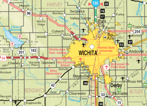 KDOT map of Sedgwick County (legend) | |
 Greenwich  Greenwich | |
| Coordinates: 37°46′58″N 97°12′13″W / 37.78278°N 97.20361°WCoordinates: 37°46′58″N 97°12′13″W / 37.78278°N 97.20361°W[1] | |
| Country | United States |
| State | Kansas |
| County | Sedgwick |
| Elevation[1] | 1,401 ft (427 m) |
| Time zone | UTC-6 (CST) |
| • Summer (DST) | UTC-5 (CDT) |
| ZIP code | 67055 [2] |
| Area code | 316 |
| FIPS code | 20-28700 [1] |
| GNIS ID | 473873 [1] |
Greenwich (pronounced /ˈɡriːnwɪtʃ/)[3] is an unincorporated community in Sedgwick County, Kansas, United States. It is located northeast of 53rd St North and Greenwich Rd.
History
Greenwich had its start by the building of the St. Louis, Fort Scott & Wichita Railroad through that territory.[4].
The first post office in Greenwich was established in September 1874.[5]
Geography
Climate
The climate in this area is characterized by hot, humid summers and generally mild to cool winters. According to the Köppen Climate Classification system, Greenwich has a humid subtropical climate, abbreviated "Cfa" on climate maps.[6]
References
- 1 2 3 4 Geographic Names Information System (GNIS) details for Greenwich, Kansas; United States Geological Survey (USGS); October 13, 1978.
- ↑ ZIP Code Lookup
- ↑ William Allen White School of Journalism and Public Information (1955). A pronunciation guide to Kansas place names. Lawrence, KS: University of Kansas. p. 13.
- ↑ Bentley, Orsemus Hills (1910). History of Wichita and Sedgwick County, Kansas: Past and Present. Windmill Publications. p. 630.
- ↑ "Kansas Post Offices, 1828-1961". Kansas Historical Society. Archived from the original on 9 October 2013. Retrieved 23 June 2014.
- ↑ Climate Summary for Greenwich, Kansas
External links
Municipalities and communities of Sedgwick County, Kansas, United States | ||
|---|---|---|
| Cities | 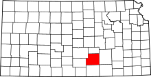 | |
| CDPs | ||
| Unincorporated communities | ||
| Townships | ||
| Footnotes | ‡This populated place also has portions in an adjacent county or counties | |
This article is issued from
Wikipedia.
The text is licensed under Creative Commons - Attribution - Sharealike.
Additional terms may apply for the media files.