Furley, Kansas
| Furley, Kansas | |
|---|---|
| Unincorporated community | |
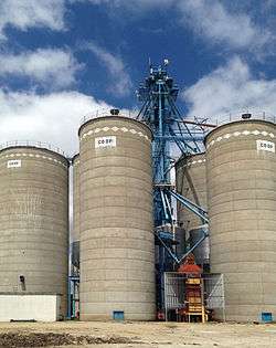 Furley Coop (2015) | |
| Coordinates: 37°52′45″N 097°12′46″W / 37.87917°N 97.21278°WCoordinates: 37°52′45″N 097°12′46″W / 37.87917°N 97.21278°W | |
| Country | United States |
| State | Kansas |
| County | Sedgwick |
| Township | Lincoln |
| Elevation | 1,411 ft (430 m) |
| Time zone | UTC-6 (CST) |
| • Summer (DST) | UTC-5 (CDT) |
| Area code | 316 |
| FIPS code[1] | 20-24975 |
| GNIS feature ID[1] | 473703 |


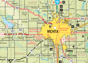
Furley is an unincorporated community in Sedgwick County, Kansas, United States. It is located northwest of Greenwich Rd and 101st St N.
History
19th century

In 1887, the Chicago, Kansas and Nebraska Railway built a branch line north-south from Herington through Furley to Caldwell.[2] By 1893, this branch line was incrementally built to Fort Worth, Texas. It foreclosed in 1891 and was taken over by Chicago, Rock Island and Pacific Railway, which shut down in 1980 and reorganized as Oklahoma, Kansas and Texas Railroad, merged in 1988 with Missouri Pacific Railroad, and finally merged in 1997 with Union Pacific Railroad. Most locals still refer to this railroad as the "Rock Island".
A post office was opened in Furley in 1887, and remained in operation until it was discontinued in 1953.[3]
Geography
Furley is located at 37°52′45″N 97°12′46″W / 37.87917°N 97.21278°W (37.8791795, -97.2128162).[4]
Education
Furley is part of the Remington USD 206 public school district. The Remington High School mascot is a Bronco.
- Frederic Remington High School at 8850 NW Meadowlark Road, north of Brainerd.
- Remington Middle School at 316 E Topeka Street in Whitewater.
- Remington Elementary School at 200 E Ellis Avenue in Potwin.
Infrastructure
Transportation
I-135 highway is approximately 6 miles west of the community. The Union Pacific Railroad runs through Furley.
Utilities
- Internet
- Wireless is provided by Pixius Communications.
- Satellite is provided by HughesNet, StarBand, WildBlue.
- TV
- Satellite is provided by DirecTV, Dish Network.
- Terrestrial is provided by regional digital TV stations.
- Water
- Rural is provided by Harvey County RWD #1.
References
- 1 2 "US Board on Geographic Names". United States Geological Survey. 2007-10-25. Retrieved 2008-01-31.
- ↑ Rock Island Rail History
- ↑ "Kansas Post Offices, 1828-1961". Kansas Historical Society. Archived from the original on October 9, 2013. Retrieved 23 June 2014.
- ↑ "Furley". Geographic Names Information System. United States Geological Survey.
External links
| Wikimedia Commons has media related to Furley, Kansas. |
- Schools
- USD 206, local school district
- Maps
- Sedgwick County Maps: Current, Historic, KDOT
- Remington-Whitewater school district boundary map, USD 206
Municipalities and communities of Sedgwick County, Kansas, United States | ||
|---|---|---|
| Cities | 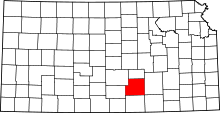 | |
| CDPs | ||
| Unincorporated communities | ||
| Townships | ||
| Footnotes | ‡This populated place also has portions in an adjacent county or counties | |