Greensboro, Alabama
| Greensboro, Alabama | |
|---|---|
| City | |
 Main Street in Greensboro | |
 Location of Greensboro in Hale County, Alabama. | |
| Coordinates: 32°42′8″N 87°35′46″W / 32.70222°N 87.59611°WCoordinates: 32°42′8″N 87°35′46″W / 32.70222°N 87.59611°W | |
| Country | United States |
| State | Alabama |
| County | Hale |
| Area[1] | |
| • Total | 2.39 sq mi (6.18 km2) |
| • Land | 2.38 sq mi (6.16 km2) |
| • Water | 0.01 sq mi (0.02 km2) |
| Elevation | 282 ft (86 m) |
| Population (2010) | |
| • Total | 2,497 |
| • Estimate (2017)[2] | 2,314 |
| • Density | 973.50/sq mi (375.85/km2) |
| Time zone | UTC-6 (Central (CST)) |
| • Summer (DST) | UTC-5 (CDT) |
| ZIP code | 36744 |
| Area code(s) | 334 |
| FIPS code | 01-31720 |
| GNIS feature ID | 0157974 |
Greensboro is a city in Hale County, Alabama, United States. At the 2010 census the population was 2,497,[3] down from 2,731 at the 2000 census. The city is the county seat of Hale County, Alabama, which was not organized until 1867. It is part of the Tuscaloosa, Alabama Metropolitan Statistical Area.
History
Greensboro was incorporated as a town in December 1823 as "Greensborough". It was named in honor of American Revolutionary War general Nathanael Greene.[4] The name was soon simplified to "Greensboro". The community was known as "Troy" prior to incorporation.[5]
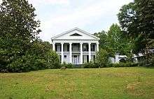
Reflecting the history of the antebellum years and a culture built on cotton plantations to produce the commodity crop, several sites on the National Register of Historic Places in or near Greensboro are connected to this past. These include Glencairn, the Greensboro Historic District, Magnolia Grove, the McGehee-Stringfellow House, Millwood, and the Payne House.[6]
One hundred years later, African Americans in Greensboro were among those in the state continuing to work to regain their civil rights after years of second-class status under Jim Crow. Rev. Martin Luther King Jr., leader of the Southern Christian Leadership Conference, came here in the course of his civil rights projects in the state. In 1968, he hid from Ku Klux Klan members in what is now operated as the Safe House Black Historic Museum.
Geography
Greensboro is slightly southeast of the center of Hale County and is crossed by Alabama State Routes 14, 25, and 69. SR 14 leads northwest 21 miles (34 km) to Eutaw and east 19 miles (31 km) to Marion. SR 25 leads northeast through Talladega National Forest 36 miles (58 km) to Brent and south 32 miles (51 km) to Thomaston. SR 69 leads north 38 miles (61 km) to Tuscaloosa and southwest 33 miles (53 km) to Linden. Demopolis is 25 miles (40 km) to the southwest via SR 69 and U.S. Route 80.
According to the U.S. Census Bureau, Greensboro has a total area of 2.4 square miles (6.2 km2), of which 0.01 square miles (0.02 km2), or 0.40%, are water.[3]
Climate
The climate in this area is characterized by hot, humid summers and generally mild to cool winters. According to the Köppen Climate Classification system, Greensboro has a humid subtropical climate, abbreviated "Cfa" on climate maps.[7]
Demographics
| Historical population | |||
|---|---|---|---|
| Census | Pop. | %± | |
| 1850 | 2,500 | — | |
| 1870 | 1,760 | — | |
| 1880 | 1,833 | 4.1% | |
| 1890 | 1,759 | −4.0% | |
| 1900 | 2,416 | 37.4% | |
| 1910 | 2,048 | −15.2% | |
| 1920 | 1,809 | −11.7% | |
| 1930 | 1,795 | −0.8% | |
| 1940 | 2,034 | 13.3% | |
| 1950 | 2,217 | 9.0% | |
| 1960 | 3,081 | 39.0% | |
| 1970 | 3,371 | 9.4% | |
| 1980 | 3,248 | −3.6% | |
| 1990 | 3,047 | −6.2% | |
| 2000 | 2,731 | −10.4% | |
| 2010 | 2,497 | −8.6% | |
| Est. 2017 | 2,314 | [2] | −7.3% |
| U.S. Decennial Census[8] 2013 Estimate[9] | |||


As of the census[11] of 2000, there were 2,731 people, 1,026 households, and 688 families residing in the city. The population density was 1,146.5 people per square mile (443.0/km²). There were 1,142 housing units at an average density of 479.4 per square mile (185.3/km²). The racial makeup of the city was 38.30% White, 60.89% Black or African American, 0.04% Native American, and 0.77% from two or more races. 0.88% of the population were Hispanic or Latino of any race.
There were 1,026 households, of which 32.3% had children under the age of 18 living with them, 35.1% were married couples living together, 27.3% had a female householder with no husband present, and 32.9% were non-families. 31.2% of all households were made up of individuals and 14.6% had someone living alone who was 65 years of age or older. The average household size was 2.56 and the average family size was 3.21.
In the city, the population was spread out with 28.6% under the age of 18, 10.5% from 18 to 24, 20.9% from 25 to 44, 20.5% from 45 to 64, and 19.4% who were 65 years of age or older. The median age was 37 years. For every 100 females, there were 86.8 males. For every 100 females age 18 and over, there were 74.6 males.
The median income for a household in the city was $22,930, and the median income for a family was $28,990. Males had a median income of $36,071 versus $23,224 for females. The per capita income for the city was $13,271. About 27.2% of families and 35.3% of the population were below the poverty line, including 47.1% of those under age 18 and 26.2% of those age 65 or over.
2010 census
As of the census[11] of 2010, there were 2,497 people, 1,045 households, and 629 families residing in the city. The population density was 1,040.4 people per square mile (402.7/km²). There were 1,195 housing units at an average density of 497.9 per square mile (192.7/km²). The racial makeup of the city was 66.5% Black or African American, 32.0% White, 0.2% Native American, and 0.6% from two or more races. 0.5% of the population were Hispanic or Latino of any race.
There were 1,045 households, of which 25.6% had children under the age of 18 living with them, 30.4% were married couples living together, 25.2% had a female householder with no husband present, and 39.8% were non-families. 37.0% of all households were made up of individuals and 15.9% had someone living alone who was 65 years of age or older. The average household size was 2.31 and the average family size was 3.07.
In the city, the population was spread out with 24.9% under the age of 18, 7.9% from 18 to 24, 20.5% from 25 to 44, 26.8% from 45 to 64, and 19.9% who were 65 years of age or older. The median age was 42 years. For every 100 females, there were 81.1 males. For every 100 females age 18 and over, there were 88.3 males.
The median income for a household in the city was $30,082, and the median income for a family was $36,379. Males had a median income of $28,869 versus $22,528 for females. The per capita income for the city was $16,277. About 19.0% of families and 23.8% of the population were below the poverty line, including 34.9% of those under age 18 and 23.7% of those age 65 or over.
Government and infrastructure
The city of Greensboro has a mayor-council form of government. There is a full-time police force with approximately 13 officers. The city has a volunteer fire department.
Greensboro is served by one public K-12 public school, Greensboro Public School, with two campuses. There is one private K-12 school, Southern Academy.
Notable people
- Anthony Bryant, defensive tackle in the NFL
- Scott Burton, sculptor and performance artist
- Alfred Chapman, Los Angeles real estate attorney and investor, and one of the founders of Orange, California
- John Gayle, seventh governor of the U.S. state of Alabama (1831–1835)
- Amelia Gayle Gorgas, former librarian for the University of Alabama and mother of Surgeon General William C. Gorgas
- Richmond Pearson Hobson (1870–1937), member of the United States House of Representatives and Medal of Honor recipient
- Grady Jackson, professional football player
- Pete Jarman (1892–1955), member of the United States House of Representatives and former United States Ambassador to Australia
- Andrew Killgore (1919–2016), United States Foreign Service Officer and ambassador to Qatar
- Thomas E. Knight, 13th Lieutenant Governor of Alabama and 19th Attorney General of Alabama
- Hedgemon Lewis, boxer, former world title contender
- William Burns Paterson, teacher, founder of Tullibody Academy and Alabama State University
- Israel Pickens, third governor of Alabama (1821–1825)
- Eugene Sawyer, mayor of Chicago
- Thomas Seay, 27th governor of Alabama (1886–1890)
- Armistead I. Selden, Jr. (1921–1985), member of the United States House of Representatives and former United States Ambassador to New Zealand, Fiji, the Kingdom of Tonga, and Western Samoa
- Little Sonny, electric blues musician and songwriter
- Barry Wagner, former wide receiver/linebacker in the Arena Football League
- Bob Wiggins, outfielder in the Negro American League
- Henry Williams, former NFL defensive back
- Lamanzer Williams, former NFL defensive end
References
- ↑ "2017 U.S. Gazetteer Files". United States Census Bureau. Retrieved Jul 7, 2018.
- 1 2 "Population and Housing Unit Estimates". Retrieved March 24, 2018.
- 1 2 "Geographic Identifiers: 2010 Demographic Profile Data (G001): Greensboro city, Alabama". American Factfinder. U.S. Census Bureau. Retrieved April 12, 2017.
- ↑ Gannett, Henry (1905). The Origin of Certain Place Names in the United States. Govt. Print. Off. p. 144.
- ↑ Hubbs, G. Ward (2003). Guarding Greensboro: A Confederate Company in the Making of a Southern Community. Athens, Georgia: University of Georgia Press. pp. 10–12. ISBN 0-8203-2505-8.
- ↑ National Park Service (2008-04-15). "National Register Information System". National Register of Historic Places. National Park Service.
- ↑ "Greensboro, Alabama Köppen Climate Classification". Weatherbase. Retrieved 2015-10-17.
- ↑ "U.S. Decennial Census". Census.gov. Archived from the original on May 12, 2015. Retrieved June 6, 2013.
- ↑ "Annual Estimates of the Resident Population: April 1, 2010 to July 1, 2013". Census.gov. Archived from the original on May 22, 2014. Retrieved June 3, 2014.
- ↑ "Safe House Museum". Tour West Alabama. Retrieved August 5, 2017.
- 1 2 "American FactFinder". United States Census Bureau. Archived from the original on September 11, 2013. Retrieved January 31, 2008.
Municipalities and communities of Hale County, Alabama, United States | ||
|---|---|---|
| City | 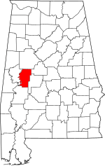 | |
| Towns | ||
| Unincorporated communities | ||
| Ghost towns | ||
| Footnotes | ‡This populated place also has portions in an adjacent county or counties | |