Arcola, Alabama
| Arcola, Alabama | |
|---|---|
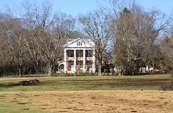 Portion of the settlement site, the Hatch Plantation | |
 Arcola  Arcola | |
| Coordinates: 32°33′58″N 87°46′55″W / 32.56617°N 87.78183°W | |
| Country | United States |
| State | Alabama |
| County | Marengo |
| Elevation | 123 ft (37 m) |
| Time zone | UTC-6 (Central (CST)) |
| • Summer (DST) | UTC-5 (CDT) |
| ZIP code | 36742 |
| Area code(s) | 334 |
Arcola is a ghost town on the Black Warrior River in what is now Hale County, formerly Marengo County, Alabama.[1] Named to honor the French victory during the Battle of Arcola, it was established in the early 1820s by former French Bonapartists as part of their Vine and Olive Colony, after they were forced to abandon their first town at Demopolis and many found Aigleville unsuitable.[2] The first settler at the site was Frederic Ravesies, who established himself at what later became the Hatch Plantation.[3] Although never more than a village, Arcola became the largest settlement in the colony. Beginning in the 1830s American settlers moved into the area and purchased most of the former French land grants, primarily using Arcola as a river landing. By the 1850s the French settlement had disappeared, replaced by a community of adjoining plantations.[2]
Geography
Arcola is located at 32°33′58″N 87°46′55″W / 32.56617°N 87.78183°WCoordinates: 32°33′58″N 87°46′55″W / 32.56617°N 87.78183°W and has an elevation of 128 feet (39 m).[1]
References
- 1 2 U.S. Geological Survey Geographic Names Information System: Arcola
- 1 2 Harris, W. Stuart (1977). Dead Towns of Alabama. Tuscaloosa, Alabama: University of Alabama Press. p. 60. ISBN 0-8173-1125-4.
- ↑ Smith, Winston (1967). Days of Exile: The Story of the Vine and Olive Colony in Alabama. Tuscaloosa, Alabama: W. B. Drake and Son. pp. 76–77.
Municipalities and communities of Hale County, Alabama, United States | ||
|---|---|---|
| City | 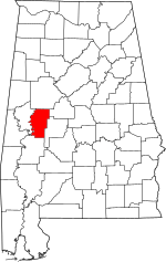 | |
| Towns | ||
| Unincorporated communities | ||
| Ghost towns | ||
| Footnotes | ‡This populated place also has portions in an adjacent county or counties | |