Greenbush (CDP), Wisconsin
| Greenbush, Wisconsin | |
|---|---|
| Census-designated place | |
 Downtown Greenbush | |
 Greenbush, Wisconsin | |
| Coordinates: 43°46′36″N 88°05′02″W / 43.77667°N 88.08389°WCoordinates: 43°46′36″N 88°05′02″W / 43.77667°N 88.08389°W | |
| Country | United States |
| State | Wisconsin |
| County | Sheboygan |
| Area | |
| • Total | 0.687 sq mi (1.78 km2) |
| • Land | 0.685 sq mi (1.77 km2) |
| • Water | 0.002 sq mi (0.005 km2) |
| Elevation | 971 ft (296 m) |
| Population (2010 census) | |
| • Total | 162 |
| • Density | 240/sq mi (91/km2) |
| Time zone | UTC-6 (Central (CST)) |
| • Summer (DST) | UTC-5 (CDT) |
| ZIP code | 53026 |
| Area code(s) | 920 |
| GNIS feature ID | 1565833[1] |

Greenbush is an unincorporated census-designated place located in the town of Greenbush, Sheboygan County, Wisconsin, United States. Greenbush is located near Wisconsin Highway 23 5.5 miles (8.9 km) west-northwest of Plymouth. Greenbush has a post office with ZIP code 53026.[2] As of the 2010 census, its population was 162.[3] The Sylvanus Wade House is located in Greenbush.[4]
References
| Wikimedia Commons has media related to Greenbush, Wisconsin. |
- ↑ U.S. Geological Survey Geographic Names Information System: Greenbush (CDP), Wisconsin
- ↑ ZIP Code Lookup
- ↑ "American FactFinder". U.S. Census Bureau. Retrieved 4 April 2011.
- ↑ National Park Service (2010-07-09). "National Register Information System". National Register of Historic Places. National Park Service.
Municipalities and communities of Sheboygan County, Wisconsin, United States | ||
|---|---|---|
| Cities | 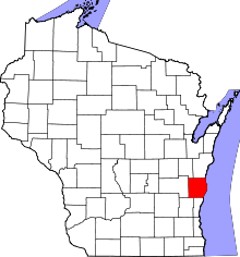 | |
| Villages | ||
| Towns | ||
| CDPs | ||
| Unincorporated communities | ||
| Ghost towns/neighborhoods | ||
| Footnotes | ‡This populated place also has portions in an adjacent county or counties | |
This article is issued from
Wikipedia.
The text is licensed under Creative Commons - Attribution - Sharealike.
Additional terms may apply for the media files.