Graysville, Indiana
| Graysville, Indiana | |
|---|---|
| Unincorporated community | |
 | |
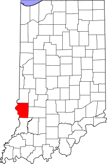 Sullivan County's location in Indiana | |
 Graysville Sullivan County, Indiana | |
| Coordinates: 39°07′03″N 87°33′22″W / 39.11750°N 87.55611°WCoordinates: 39°07′03″N 87°33′22″W / 39.11750°N 87.55611°W | |
| Country | United States |
| State | Indiana |
| County | Sullivan |
| Township | Turman |
| Elevation[1] | 568 ft (173 m) |
| Time zone | UTC-5 (Eastern (EST)) |
| • Summer (DST) | UTC-4 (EDT) |
| ZIP code | 47882 |
| Area code(s) | 812, 930 |
| FIPS code | 18-29106[2] |
| GNIS feature ID | 435374 |
Graysville is an unincorporated community in Turman Township, Sullivan County, in the U.S. state of Indiana.[3]
The community is part of the Terre Haute Metropolitan Statistical Area.
History
Graysville was named after its founder, Joe Gray.[4] The post office at Graysville has been in operation since 1849.[5]
Geography
Graysville is located at 39°07′03″N 87°33′22″W / 39.11750°N 87.55611°W.
References
- ↑ "US Board on Geographic Names". United States Geological Survey. October 25, 2007. Retrieved 2016-08-31.
- ↑ "American FactFinder". United States Census Bureau. Archived from the original on 2013-09-11. Retrieved 2008-01-31.
- ↑ "Graysville, Indiana". Geographic Names Information System. United States Geological Survey. Retrieved August 5, 2017.
- ↑ Gannett, Henry (1905). The Origin of Certain Place Names in the United States. Govt. Print. Off. p. 142.
- ↑ "Sullivan County". Jim Forte Postal History. Retrieved August 31, 2016.
Municipalities and communities of Sullivan County, Indiana, United States | ||
|---|---|---|
| Cities | ||
| Towns | ||
| Townships | ||
| Unincorporated communities |
| |
| Ghost towns | ||
| Footnotes | ‡This populated place also has portions in an adjacent county or counties | |
This article is issued from
Wikipedia.
The text is licensed under Creative Commons - Attribution - Sharealike.
Additional terms may apply for the media files.