Grateley
| Grateley | |
|---|---|
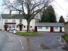 The Plough Inn | |
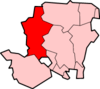
 Grateley Grateley shown within Hampshire | |
| Population | 645 (2011 Census including Palestine, Hampshire)[1] |
| OS grid reference | SU2774441883 |
| District | |
| Shire county | |
| Region | |
| Country | England |
| Sovereign state | United Kingdom |
| Post town | Andover |
| Postcode district | SP11 |
| Dialling code | 01264 |
| Police | Hampshire |
| Fire | Hampshire |
| Ambulance | South Central |
| EU Parliament | South East England |
| UK Parliament | |
Grateley is a village and civil parish in the north west of Hampshire, England.
The name is derived from the Old English grēat lēah, meaning 'great wood or clearing'.[2]
The village is divided into two distinct settlements, 0.75 miles (1.21 km) apart: the old village and a newer settlement built around the railway station on the West of England Main Line.[3] The hamlet of Palestine adjoins the railway station settlement, although it is located in the civil parish of Over Wallop.[4]
Grateley lies just to the south of the prehistoric hill fort of Quarley Hill. The parish covers 1,551 acres (6.28 km2) with 616 people[5] living in 250 dwellings. The village has two shops, two pubs, a thirteenth-century church dedicated to St Leonard, a primary school, a school for children with Aspergers Syndrome, a railway station, a small business park, a golf driving range, and is surrounded by farmland with ancient footpaths and droveways.
King Æthelstan issued his first official law code in Grateley in about 930 AD.[6]
In the 20th century Grateley was one of many ammunition dumps during the World Wars.[7]
The economic history of Grateley is agricultural, but less than 10% of the village population now rely upon agriculture as an occupation.
Notes
- ↑ "Civil Parish population 2011". Neighbourhood Statistics. Office for National Statistics. Retrieved 18 December 2016.
- ↑ "Grateley, Hampshire". Key to English Place Names. University of Nottingham.
- ↑ "Introduction". Grateley Parish Council.
- ↑ Map of Grateley, Hampshire (Map). Cartography by Ordnance Survey. streetmap.co.uk. Retrieved July 19, 2012.
- ↑ "Neighbourhood Statistics (Test Valley Borough)". Office for National Statistics. Retrieved July 29, 2012.
- ↑ Lavelle, Ryan (2005). "Why Grateley? Reflections on Anglo-Saxon Kingship in a Hampshire Landscape" (PDF). Hampshire Studies: Proceedings of the Hampshire Field Club and Archaeological Society. 60: 154–69.
- ↑ "History - Part twelve". Grateley Parish Council.
Later, Grateley, like many areas within reach of the south coast ports, became a munitions store for part of the invasion force involved in Operation Overlord.
External links
![]()