South Acworth, New Hampshire
| South Acworth, New Hampshire | |
|---|---|
| Unincorporated community | |
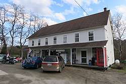 Village Store | |
 South Acworth  South Acworth | |
| Coordinates: 43°11′27″N 72°17′07″W / 43.19083°N 72.28528°WCoordinates: 43°11′27″N 72°17′07″W / 43.19083°N 72.28528°W | |
| Country | United States |
| State | New Hampshire |
| County | Sullivan |
| Town | Acworth |
| Elevation | 830 ft (250 m) |
| Time zone | UTC-5 (Eastern (EST)) |
| • Summer (DST) | UTC-4 (EDT) |
| ZIP code | 03607 |
| Area code(s) | 603 |
| GNIS feature ID | 870014[1] |
South Acworth is an unincorporated community in the town of Acworth in Sullivan County, New Hampshire, United States. It is located around a dam on the Cold River, 2 miles (3 km) south of and 700 feet (210 m) downhill from the Acworth town center. New Hampshire Route 123A passes through the village, heading east to New Hampshire Route 10 in the town of Marlow and west to Alstead.
South Acworth has a separate ZIP code (03607) from the rest of Acworth.
References
Municipalities and communities of Sullivan County, New Hampshire, United States | ||
|---|---|---|
| City | 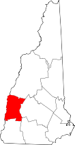 | |
| Towns | ||
| CDPs | ||
| Other villages | ||
This article is issued from
Wikipedia.
The text is licensed under Creative Commons - Attribution - Sharealike.
Additional terms may apply for the media files.