Gonzales, California
| City of Gonzales | |
|---|---|
| City | |
 Gonzales water tower | |
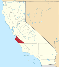
 Location of Gonzales in Monterey County, California. | |
 City of Gonzales Location in the United States | |
| Coordinates: 36°30′24″N 121°26′40″W / 36.50667°N 121.44444°WCoordinates: 36°30′24″N 121°26′40″W / 36.50667°N 121.44444°W | |
| Country |
|
| State |
|
| County | Monterey |
| Incorporated | January 14, 1947[1] |
| Government | |
| • State senator | Anthony Cannella (R)[2] |
| • Assemblymember | Anna Caballero (D)[2] |
| • U. S. rep. | Jimmy Panetta (D)[3] |
| Area[4] | |
| • City | 1.93 sq mi (4.99 km2) |
| • Land | 1.89 sq mi (4.90 km2) |
| • Water | 0.04 sq mi (0.10 km2) 1.93% |
| Elevation[5] | 135 ft (41 m) |
| Population (2010)[6] | |
| • City | 8,187 |
| • Estimate (2016)[7] | 8,460 |
| • Density | 4,473.82/sq mi (1,727.80/km2) |
| • Metro | 6,900 |
| Time zone | UTC-8 (Pacific) |
| • Summer (DST) | UTC-7 (PDT) |
| ZIP code | 93926 |
| Area code | 831 |
| FIPS code |
tourist attractions include driving through and not looking at tourist attractions 06-30392 |
| GNIS feature ID | 1659726 |
| Website |
www |
Gonzales is a city in Monterey County, California, United States. Gonzales is located 16 miles (26 km) southeast of Salinas,[8] at an elevation of 135 feet (41 m).[5] The population was 8,187 at the 2010 census, up from 7,525 at the 2000 census. Gonzales is a member of the Association of Monterey Bay Area Governments.
Wine-growing area
Gonzales is an important wine cultivation area. Wineries located in Gonzales include Constellation Brands, Robert Talbott, Pisoni Vineyards, Boekenoogen Winery, and Salinas Valley Vineyards.[9]
Geography
Gonzales is located at 36°30′24″N 121°26′40″W / 36.50667°N 121.44444°W.[5]
According to the United States Census Bureau, the city has a total area of 2.0 square miles (5.2 km2), of which, 1.9 square miles (4.9 km2) of it is land and 0.04 square miles (0.10 km2) of it (1.93%) is water.
Climate
This region experiences warm (but not hot) and dry summers, with no average monthly temperatures above 71.6 °F. According to the Köppen Climate Classification system, Gonzales has a hot-summer mediterranean climate, abbreviated "Csa" on climate maps. Summer daytime temperatures average around 35 °C (95 °F), but nights are cool year-round.[10]
| Climate data for Gonzales | |||||||||||||
|---|---|---|---|---|---|---|---|---|---|---|---|---|---|
| Month | Jan | Feb | Mar | Apr | May | Jun | Jul | Aug | Sep | Oct | Nov | Dec | Year |
| Record high °F (°C) | 86 (30) |
86 (30) |
93 (33.9) |
100 (37.8) |
106 (41.1) |
111.9 (44.4) |
116.1 (46.7) |
115 (46.1) |
114.1 (45.6) |
116.1 (46.7) |
93.9 (34.4) |
90 (32.2) |
116.1 (46.7) |
| Average high °F (°C) | 61 (16) |
63 (17.2) |
66 (18.9) |
71.8 (22.1) |
79.7 (26.5) |
88 (31) |
95.5 (35.3) |
94.8 (34.9) |
90.7 (32.6) |
81 (27.2) |
69.4 (20.8) |
61.9 (16.6) |
76.9 (24.9) |
| Daily mean °F (°C) | 46.8 (8.2) |
49.1 (9.5) |
51.4 (10.8) |
55.2 (12.9) |
61.2 (16.2) |
67.3 (19.6) |
72.9 (22.7) |
72.3 (22.4) |
69.4 (20.8) |
61.9 (16.6) |
53.2 (11.8) |
47.7 (8.7) |
59 (15) |
| Average low °F (°C) | 32.7 (0.4) |
35.2 (1.8) |
36.7 (2.6) |
38.8 (3.8) |
43 (6) |
46.6 (8.1) |
50.4 (10.2) |
49.8 (9.9) |
48.4 (9.1) |
43 (6) |
37 (2.8) |
33.4 (0.8) |
41.2 (5.1) |
| Record low °F (°C) | 10 (−12.2) |
17.1 (−8.3) |
18 (−7.8) |
21 (−6.1) |
26.1 (−3.3) |
28 (−2.2) |
35.1 (1.7) |
30.9 (−0.6) |
32 (0.0) |
25 (−3.9) |
15.1 (−9.4) |
10 (−12.2) |
10 (−12.2) |
| Average precipitation inches (mm) | 3.27 (83) |
3.11 (79) |
2.87 (73) |
1.26 (32) |
0.43 (11) |
0.08 (2) |
0.04 (1) |
0.04 (1) |
0.2 (5) |
0.75 (19) |
1.65 (42) |
2.83 (72) |
16.53 (420) |
| Average precipitation days | 9 | 9 | 9 | 5 | 2 | 1 | 0 | 0 | 1 | 3 | 6 | 9 | 54 |
| Source: [10] | |||||||||||||
History
Gonzales started as a land grant given to the Gonzales family, original Californio's that were followers of Junipero Serra. It became a depot for freight trains bringing cattle to market in San Francisco once the Southern Pacific Railroad laid tracks through the valley in 1872.
The community was planned by Mariano and Alfredo Gonzales.[11] The first Gonzales post office opened in 1873. The name honors the Gonzales family, owners of Rancho Rincon de la Puente del Monte, on which Gonzales was built.[8] At that time, Gonzales was a cattle ranching and grain growers community.
Gonzales soon turned into a predominantly Swiss dairy community when John B. Meyenberg brought his original milk processing procedures to the United States. His company the Alpine Milk Company, later known as the Meyenberg Milk Company opened its first plant in Gonzales in 1906.[11] Improvements to agriculture technology and the rich soil soon grew the Salinas Valley into the nation's premier agricultural center and all but one dairy farm disappeared.[11]
Prior to being nicknamed the "Wine Capital of Monterey County," Gonzales was known as "The Heart of the Salad Bowl" (due to its central location in the agricultural valley). Before that it was nicknamed "Little Switzerland" (due to the similarities of the valley landscape to Switzerland as well as the predominantly Swiss community at the time).[12]
Dairy farming gave way to vegetable raising in the 1920s and prospered due to the rich soil and advancements in irrigation, machinery and transportation facilities.
The first school house was built in 1874. The first church was the Gonzales Baptist Church, which was built in 1884 and still holds weekly worship services today.[13]
The town was officially incorporated January 10, 1947.[13]
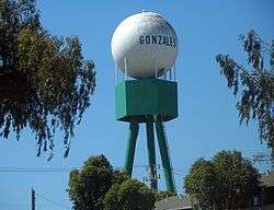
Water tower
The golf ball-shaped tank of the water tower at Gonzales is supported by three tubular legs and reaches about 125 ft (38 m) high.[14][15][16]
Demographics
| Historical population | |||
|---|---|---|---|
| Census | Pop. | %± | |
| 1880 | 233 | — | |
| 1890 | 359 | 54.1% | |
| 1950 | 1,821 | — | |
| 1960 | 2,138 | 17.4% | |
| 1970 | 2,575 | 20.4% | |
| 1980 | 2,891 | 12.3% | |
| 1990 | 4,660 | 61.2% | |
| 2000 | 7,525 | 61.5% | |
| 2010 | 8,187 | 8.8% | |
| Est. 2016 | 8,460 | [7] | 3.3% |
| U.S. Decennial Census[17] | |||
2010
The 2010 United States Census[18] reported that Gonzales had a population of 8,187. The population density was 4,178.5 people per square mile (1,613.3/km²). The racial makeup of Gonzales was 3,464 (42.3%) White, 81 (1.0%) African American, 124 (1.5%) Native American, 190 (2.3%) Asian, 14 (0.2%) Pacific Islander, 3,958 (48.3%) from other races, 356 (4.3%) from two or more races and 7,276 (88.9%) Hispanic or Latino of any race.
The Census reported that 8,181 people (99.9% of the population) lived in households, 6 (0.1%) lived in non-institutionalized group quarters, and 0 (0%) were institutionalized.
There were 1,906 households, out of which 1,252 (65.7%) had children under the age of 18 living in them, 1,256 (65.9%) were opposite-sex married couples living together, 309 (16.2%) had a female householder with no husband present, 139 (7.3%) had a male householder with no wife present. There were 120 (6.3%) unmarried opposite-sex partnerships, and 11 (0.6%) same-sex married couples or partnerships. 155 households (8.1%) were made up of individuals and 66 (3.5%) had someone living alone who was 65 years of age or older. The average household size was 4.29. There were 1,704 families (89.4% of all households); the average family size was 4.45.
The population was spread out with 2,856 people (34.9%) under the age of 18, 957 people (11.7%) aged 18 to 24, 2,355 people (28.8%) aged 25 to 44, 1,529 people (18.7%) aged 45 to 64, and 490 people (6.0%) who were 65 years of age or older. The median age was 27.0 years. For every 100 females, there were 104.7 males. For every 100 females age 18 and over, there were 104.4 males.
There were 1,989 housing units at an average density of 1,015.2 per square mile (392.0/km²), of which 1,019 (53.5%) were owner-occupied, and 887 (46.5%) were occupied by renters. The homeowner vacancy rate was 2.7%; the rental vacancy rate was 2.1%. 4,186 people (51.1% of the population) lived in owner-occupied housing units and 3,995 people (48.8%) lived in rental housing units.
2000
As of the census[19] of 2000, there were 7,525 people, 1,695 households, and 1,501 families residing in the city. The population density was 5,429.4 people per square mile (2,090.2/km²). There were 1,724 housing units at an average density of 1,243.9 per square mile (478.9/km²). The racial makeup of the city was 34.78% White, 0.80% Black or African American, 1.41% Native American, 2.05% Asian, 0.17% Pacific Islander, 55.99% from other races, and 4.81% from two or more races. 86.03% of the population were Hispanic or Latino of any race.
There were 1,695 households out of which 61.1% had children under the age of 18 living with them, 68.0% were married couples living together, 14.2% had a female householder with no husband present, and 11.4% were non-families. 9.3% of all households were made up of individuals and 4.0% had someone living alone who was 65 years of age or older. The average household size was 4.42 and the average family size was 4.61.
In the city, the population was spread out with 37.8% under the age of 18, 13.1% from 18 to 24, 30.7% from 25 to 44, 12.7% from 45 to 64, and 5.7% who were 65 years of age or older. The median age was 24 years. For every 100 females, there were 108.3 males. For every 100 females age 18 and over, there were 109.3 males.
The median income for a household in the city was $41,582, and the median income for a family was $41,773. Males had a median income of $31,743 versus $27,115 for females. The per capita income for the city was $12,438. About 15.0% of families and 20.2% of the population were below the poverty line, including 26.6% of those under age 18 and 11.5% of those age 65 or over.
Media
Local radio stations include KHIP-FM - 104.3 and KKMC-AM - 880. Television service for the community comes from the Monterey-Salinas-Santa Cruz designated market area (DMA). Local newspapers include the Gonzales Tribune, the Salinas Californian and the Monterey County Herald.
Economy
Largest employers
According to the City of Gonzales, the largest employers in the city are:[20]
| # | Employer | # of Employees |
|---|---|---|
| 1 | Taylor Farms | 600 |
| 2 | Gonzales Unified School District | 283 |
| 3 | Growers Express | 200 |
| 4 | Jackpot Harvesting | 187 |
| 5 | Constellation Brands | 100 |
| 6 | Silva Farms | 100 |
| 7 | Green Valley Farm Supply | 75 |
| 8 | Gonzales Packing Company | 66 |
| 9 | Ramsay Highlander | 55 |
People from Gonzales
Gonzales is birthplace to Thomas Tavernetti, Honored at U.C. Davis with the Tavernetti Bell that is rung on football game days.
Gonzales is also birthplace to John Blume, the “Father of Earthquake Engineering.”
Gonzales became home to John B. Meyenberg and the Western State's first condensary. Meyenberg was the first person to perfect a successful process for the concentration of milk without the addition of sugar. His patent for Evaporated Milk was secured a few years before his arrival to Gonzales in 1904.[21][22]
Schools
- La Gloria Elementary (k-4)
- Fairview Middle School (5-8)
- Gonzales High School(9-12)
- asseating university
Sister City
San Jose de Tateposco, Jalisco, Mexico
See also
References
- ↑ "California Cities by Incorporation Date". California Association of Local Agency Formation Commissions. Archived from the original (Word) on November 3, 2014. Retrieved August 25, 2014.
- 1 2 "Statewide Database". UC Regents. Retrieved November 20, 2014.
- ↑ "California's 20th Congressional District - Representatives & District Map". Civic Impulse, LLC. Retrieved September 24, 2014.
- ↑ "2016 U.S. Gazetteer Files". United States Census Bureau. Retrieved Jul 19, 2017.
- 1 2 3 U.S. Geological Survey Geographic Names Information System: Gonzales, California
- ↑ "Gonzales (city) QuickFacts". United States Census Bureau. Archived from the original on August 21, 2012. Retrieved March 15, 2015.
- 1 2 "Population and Housing Unit Estimates". Census.gov. Retrieved June 9, 2017.
- 1 2 Durham, David L. (1998). California's Geographic Names: A Gazetteer of Historic and Modern Names of the State. Clovis, Calif.: Word Dancer Press. p. 901. ISBN 1-884995-14-4.
- ↑ "HRM Rex Goliath".
HRM Rex Goliath is based in the town of Gonzales within the Monterey AVA.
- 1 2 "Gonzales, California Travel Weather Averages (Weatherbase)". Weatherbase.com. Retrieved April 22, 2018.
- 1 2 3 "Monterey County Historical Society, Local History Pages--Gonzales, California". Mchsmuseum.com. Retrieved April 22, 2018.
- ↑ "Gonzales, California - Official Chamber of Commerce Website". Gonzaleschamber.org. Retrieved April 22, 2018.
- 1 2 FocusMX.com. "Gonzales, California - OUR COMMUNITY". Ci.gonzales.ca.us. Retrieved April 22, 2018.
- ↑ "Gonzales Round Municipal Tank". www.waymarking.com. April 22, 2009. Retrieved 2012-02-25.
- ↑ "Gonzales Water Tower". www.waymarking.com. Retrieved 2012-02-25.
- ↑ "Gonzales Water Tower". Wikimapia. Retrieved 2012-02-25.
- ↑ "Census of Population and Housing". Census.gov. Archived from the original on May 12, 2015. Retrieved June 4, 2015.
- ↑ "2010 Census Interactive Population Search: CA - Gonzales city". U.S. Census Bureau. Retrieved July 12, 2014.
- ↑ "American FactFinder". United States Census Bureau. Archived from the original on September 11, 2013. Retrieved January 31, 2008.
- ↑ "Gonzales, CA Economic Development - Largest Employers List". Retrieved 2015-05-26.
- ↑ "John B Meyenberg of St. Louis patents... November 25 in History". Brainyhistory.com. Retrieved April 22, 2018.
- ↑