Gog Group
| Gog Group Stratigraphic range: Early Cambrian) | |
|---|---|
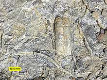 Trace fossils in a slab from the Gog Group. | |
| Type | Group |
| Sub-units | see text |
| Underlies | Mount Whyte Formation, Chancellor Group, Snake Indian Formation |
| Overlies | Miette Group |
| Thickness | up to 2,180 metres (7,150 ft) |
| Lithology | |
| Primary | Quartzose sandstone, quartzite, conglomerate |
| Other | Siltstone, mudstone, limestone, dolostone |
| Location | |
| Region |
|
| Country |
|
| Type section | |
| Named by | C.F. Deiss, 1940[1] |
The Gog Group is a stratigraphic unit in the Western Canada Sedimentary Basin. It is present in the western main ranges of the Canadian Rockies in Alberta and British Columbia, and in the Cariboo Mountains and in the central Purcell Mountains in southwestern British Columbia.[2][3] It was named by C.F. Deiss in 1940 for a type locality near Mount Assiniboine.[1][4]
Lithology and environment of deposition
The Gog Group consists primarily of thick deposits of cross-bedded quartzose sandstone and quartzite, with minor quartzitic conglomerate and sub-arkosic sandstone. It also includes mudstone, siltstone, limestone and dolostone formations. The Gog sediments are thought to have been deposited in shallow marine environments on the subsiding margin of the North American craton (Laurentia).[2][3][5]
Stratigraphy
Subdivisions
The Gog Group is subdivided into the following formations:
Jasper area (north)
| Formation | Age | Lithology | Maximum Thickness | Reference |
|---|---|---|---|---|
| Hota Formation | late Early Cambrian | arenaceous limestone | 244 m (800 ft) | [2][4][6] |
| Mahato Formation | Early Cambrian | quartzose sandstone | 240 m (790 ft) | [2][4][6] |
| Mural Formation | Early Cambrian | limestone, dolostone, shale, quartzose sandstone | 545 m (1,790 ft) | [2][4][6] |
| McNaughton Formation | Early Cambrian | quartzose sandstone, quartzite, arkosic sandstone, conglomerate | 600 m (1,970 ft) | [2][4][6] |
| Jasper Formation | Early Cambrian | arkosic sandstone, quartzite, conglomerate, argillite | 500 m (1,640 ft) | [2][4][6] |
Kicking Horse Pass area (south)
| Formation | Age | Lithology | Max. Thickness | Reference |
|---|---|---|---|---|
| Peyto Formation | late Early Cambrian | limestone, dolostone | 125 m (410 ft) | [2][4][6] |
| St. Piran Formation | Early Cambrian | quartzose sandstone | 825 m (2,710 ft) | [2][4][6] |
| Lake Louise Formation | Early Cambrian | limestone, dolostone, shale, quartzose sandstone | [2][4][6] | |
| Fort Mountain Formation | Early Cambrian | quartzose sandstone, quartzite, arkosic sandstone, conglomerate | 510 m (1,670 ft) | [2][4][6] |
| Jasper Formation | Early Cambrian | arkosic sandstone, quartzite, conglomerate, argillite | 500 m (1,640 ft) | [2][4][6] |
Paleontology
Trace fossils such as Skolithos, Cruziana, Diplocraterion, Chondrites, Planolites, Rusophycus and others are abundant in the Gog Group sediments, and Early Cambrian trilobites of the genus Olenellus are found in the Peyto Formations limestones at the top of the Group.[2][5] Small archaeocyathid bioherms have been reported from the base of the Mahato Formation, and archaeocyathids, salterellids, primitive brachiopods and echinoderms have been reported from the Mural Formation.[4]
See also
References
- 1 2 Deiss, C.F. 1940. Lower and Middle Cambrian stratigraphy of southwestern Alberta and southeastern British Columbia. Geological Society of America Bulletin, vol. 57, p. 731-794.
- 1 2 3 4 5 6 7 8 9 10 11 12 13 Hein, H. J., and M. E. McMechan (1994). Chapter 6 Proterozoic and Lower Cambrian Strata of the Western Canada Sedimentary Basin; in Geological Atlas of the Western Canada Sedimentary Basin, G.D. Mossop and I. Shetsen (comp.). Alberta, Canada: Canadian Society of Petroleum Geologists and Alberta Research Council.[Last accessed 28 June 2016].
- 1 2 Desjardins, P.R., Buatois, L.A., Pratt, B.E. and Mágano, M.G. 2010. Stratigraphy and sedimentary environments of the Lower Cambrian Gog Group in the southern Rocky Mountains of western Canada. Bulletin of Canadian Petroleum Geology, vol. 58, p. 403-439.
- 1 2 3 4 5 6 7 8 9 10 11 12 Glass, D.J. (editor) 1997. Lexicon of Canadian Stratigraphy, vol. 4, Western Canada including eastern British Columbia, Alberta, Saskatchewan and southern Manitoba. Canadian Society of Petroleum Geologists, Calgary, 1423 p. on CD-ROM. ISBN 0-920230-23-7.
- 1 2 Hein, F.J. and Arnott, R.W. 1983. Precambrian Miette conglomerates, Lower Cambrian Gog quartzites and modern braided outwash deposits, Kicking Horse Pass area. Canadian Society of Petroleum Geologists Field Trip Guidebook, 1983, 46 p.
- 1 2 3 4 5 6 7 8 9 10 Alberta Geological Survey, 2013. "Alberta Table of Formations; Alberta Energy Regulator". Retrieved 2016-06-20.