Gmina Rytwiany
| Gmina Rytwiany Rytwiany Commune | ||
|---|---|---|
| Gmina | ||
| ||
 | ||
| Coordinates (Rytwiany): 50°30′21.66″N 21°14′20.84″E / 50.5060167°N 21.2391222°ECoordinates: 50°30′21.66″N 21°14′20.84″E / 50.5060167°N 21.2391222°E | ||
| Country |
| |
| Voivodeship | Świętokrzyskie | |
| County | Staszów | |
| Seat | Rytwiany | |
| Area (through the years 2007–2010)[1] | ||
| • Total | 124.66 km2 (48.13 sq mi) | |
| Population (31 December 2010 at Census)[1] | ||
| • Total | 6,240 | |
| • Density | 50/km2 (130/sq mi) | |
| Time zone | UTC+1 (CET) | |
| • Summer (DST) | UTC+2 (CEST) | |
| Postal code | 28-236 | |
| Area code(s) | +48 15 | |
| Car plates | TSZ | |
| Website | http://www.rytwiany.com.pl | |
Gmina Rytwiany[2] is a rural gmina (administrative district) in Staszów County, Świętokrzyskie Voivodeship, in south-central Poland. Its seat is the village of Rytwiany, which lies approximately 5 kilometres (3 mi) south-east of Staszów and 58 km (36 mi) south-east of the regional capital Kielce.
The gmina covers an area of 124.66 square kilometres (48.1 sq mi), and as of 2010 its total population is ![]()
Demography
According to the 2011 Poland census, there were 6,240 people residing in Rytwiany Commune, of whom 49.2% were male and 50.8% were female. In the commune, the population was spread out with 20.7% under the age of 18, 38.4% from 18 to 44, 22.9% from 45 to 64, and 18% who were 65 years of age or older.[1]
Table 1. Population level of commune in 2010 – by age group[1] SPECIFICATION Measure
unitPOPULATION
(by age group in 2010)TOTAL 0–4 5–9 10–14 15–19 20–24 25–29 30–34 35–39 40–44 45–49 50–54 55–59 60–64 65–69 70–74 75–79 80–84 85 + I. TOTAL person 6,240 274 340 392 515 447 417 467 457 380 355 448 448 360 231 238 191 149 131 — of which in % 100 4.4 5.4 6.3 8.3 7.2 6.7 7.5 7.3 6.1 5.7 7.2 7.2 5.8 3.7 3.8 3.1 2.4 2.1 1. BY SEX A. Males person 3,067 141 157 206 256 244 220 244 228 199 192 234 212 176 100 102 73 52 31 — of which in % 49.2 2.3 2.5 3.3 4.1 3.9 3.5 3.9 3.7 3.2 3.1 3.8 3.4 2.8 1.6 1.6 1.2 0.8 0.5 B. Females person 3,173 133 183 186 259 203 197 223 229 181 163 214 236 184 131 136 118 97 100 — of which in % 50.8 2.1 2.9 3 4.2 3.3 3.2 3.6 3.7 2.9 2.6 3.4 3.8 2.9 2.1 2.2 1.9 1.6 1.6
Figure 1. Population pyramid of commune in 2010 – by age group and sex[1]
Table 2. Population level of commune in 2010 – by sex[1] SPECIFICATION Measure
unitPOPULATION
(by sex in 2010)TOTAL Males Females I. TOTAL person 6,240 3,067 3,173 — of which in % 100 49.2 50.8 1. BY AGE GROUP A. At pre-working age person 1,292 649 643 — of which in % 20.7 10.4 10.3 B. At working age. grand total person 3,824 2,060 1,764 — of which in % 61.3 33 28.3 a. at mobile working age person 2,397 1,246 1,151 — of which in | % 38.4 20 18.4 b. at non-mobile working age person 1,427 814 613 — of which in | % 22.9 13.1 9.8 C. At post-working age person 1,124 358 766 — of which in % 18 5.7 12.3

Villages
Gmina Rytwiany contains the villages and settlements of Grobla, Kłoda, Niedziałki, Pacanówka, Podborek, Ruda, Rytwiany, Sichów Duży, Sichów Mały, Strzegom, Strzegomek, Święcica, Sydzyna, Szczeka and Tuklęcz.
Neighbouring gminas
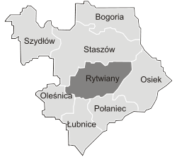
Gmina Rytwiany is bordered by the gminas of Łubnice, Oleśnica, Osiek, Połaniec, Staszów and Tuczępy.
References
- 1 2 3 4 5 6 "Local Data Bank (Bank Danych Lokalnych) – Layout by NTS nomenclature (Układ wg klasyfikacji NTS)". demografia.stat.gov.pl: GUS. 10 March 2011.
- ↑ "Rytwiany, gmina, powiat staszowski, województwo świętokrzyskie" [Rytwiany, commune, Staszów County, Świętokrzyskie Province, Poland]. Topographical map prepared in 1:10,000 scale. Aerial and satellite orthophotomap (in Polish). Head Office of Geodesy and Cartography, Poland, Warsaw. 2011. geoportal.gov.pl. Archived from the original on 21 December 2012. Retrieved 27 April 2011.
External links
| Seat |  | |
|---|---|---|
| Other villages | ||
| Parts of village |
| |
| Hamlets of village |
| |
| Colonies |
| |
| Gamekeeper's cottage |
| |
| Seat |  | |
|---|---|---|
| Urban-rural gminas | ||
| Rural gminas | ||