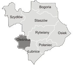
Gmina Oleśnica, Świętokrzyskie Voivodeship
| Gmina Oleśnica Oleśnica Commune | ||
|---|---|---|
| Gmina | ||
| ||
 | ||
| Coordinates (Oleśnica): 50°27′27.34″N 21°03′43.74″E / 50.4575944°N 21.0621500°ECoordinates: 50°27′27.34″N 21°03′43.74″E / 50.4575944°N 21.0621500°E | ||
| Country |
| |
| Voivodeship | Świętokrzyskie | |
| County | Staszów | |
| Seat | Oleśnica | |
| Area (through the years 2006–2010)[1] | ||
| • Total | 53.38 km2 (20.61 sq mi) | |
| Population (31 December 2010 at Census)[1] | ||
| • Total | 3,891 | |
| • Density | 73/km2 (190/sq mi) | |
| Time zone | UTC+1 (CET) | |
| • Summer (DST) | UTC+2 (CEST) | |
| Postal code | 28–220 | |
| Area code(s) | +48 41 | |
| Car plates | TSZ | |
| Website | http://www.olesnica.realnet.pl/ | |
Gmina Oleśnica[2] is a rural gmina (administrative district) in Staszów County, Świętokrzyskie Voivodeship, in south-central Poland. Its seat is the village of Oleśnica, which lies approximately 15 kilometres (9 mi) south-west of Staszów and 58 km (36 mi) south-east of the regional capital Kielce.
The gmina covers an area of 53.38 square kilometres (20.6 sq mi), and as of 2010 its total population is ![]()
Demography
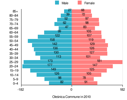
According to the 2011 Poland census, there were 3,891 people residing in Oleśnica Commune, of whom 49.7% were male and 50.3% were female. In the commune, the population was spread out with 19.3% under the age of 18, 38.9% from 18 to 44, 22.5% from 45 to 64, and 19.3% who were 65 years of age or older.[1]
Table 1. Population level of commune in 2010 – by age group[1] SPECIFICATION Measure
unitPOPULATION
(by age group in 2010)TOTAL 0–4 5–9 10–14 15–19 20–24 25–29 30–34 35–39 40–44 45–49 50–54 55–59 60–64 65–69 70–74 75–79 80–84 85 + I. TOTAL person 3891 173 176 231 274 324 354 214 257 262 271 277 229 204 130 160 149 111 95 — of which in % 100 4.4 4.5 5.9 7.0 8.3 9.1 5.5 6.6 6.7 7.0 7.1 5.9 5.2 3.3 4.1 3.8 2.9 2.4 1. BY SEX A. Males person 1932 82 98 126 149 177 173 113 130 136 142 158 122 99 47 62 52 39 27 — of which in % 49.7 2.1 2.5 3.2 3.8 4.5 4.4 2.9 3.3 3.5 3.6 4.1 3.1 2.5 1.2 1.6 1.3 1.0 0.7 B. Females person 1959 91 78 105 125 147 181 101 127 126 129 119 107 105 83 98 97 72 68 — of which in % 50.3 2.3 2.0 2.7 3.2 3.8 4.7 2.6 3.3 3.2 3.3 3.1 2.7 2.7 2.1 2.5 2.5 1.9 1.7
Figure 1. Population pyramid of commune in 2010 – by age group and sex[1]
Table 2. Population level of commune in 2010 – by sex[1] SPECIFICATION Measure
unitPOPULATION
(by sex in 2010)TOTAL Males Females I. TOTAL person 3,891 1,932 1,959 — of which in % 100 49.7 50.3 1. BY AGE GROUP A. At pre-working age person 750 395 355 — of which in % 19.3 10.2 9.1 B. At working age. grand total person 2,391 1,310 1,081 — of which in % 61.4 33.7 27.8 a. at mobile working age person 1,515 789 726 — of which in | % 38.9 20.3 18.7 b. at non-mobile working age person 876 521 355 — of which in | % 22.5 13.4 9.1 C. At post-working age person 750 227 523 — of which in % 19.3 5.8 13.4
Villages
Gmina Oleśnica contains the villages and settlements of Borzymów, Brody, Bydłowa, Kępie, Oleśnica, Pieczonogi, Podlesie, Strzelce, Sufczyce, Wojnów and Wólka Oleśnicka.
Neighbouring gminas
Gmina Oleśnica is bordered by the gminas of Łubnice, Pacanów, Rytwiany, Stopnica and Tuczępy.
References
- 1 2 3 4 5 6 "Local Data Bank (Bank Danych Lokalnych) – Layout by NTS nomenclature (Układ wg klasyfikacji NTS)". demografia.stat.gov.pl: GUS. 10 March 2011.
- ↑ "Oleśnica, gmina, powiat staszowski, województwo świętokrzyskie" [Oleśnica, commune, Staszów County, Świętokrzyskie Province, Poland]. Topographical map prepared in 1:10,000 scale. Aerial and satellite orthophotomap (in Polish). Head Office of Geodesy and Cartography, Poland, Warsaw. 2011. geoportal.gov.pl. Archived from the original on 21 December 2012. Retrieved 27 April 2011.
External links
| Seat |  | |
|---|---|---|
| Other villages | ||
| Parts of village |
| |
| Hamlets of village |
| |
| Colony |
| |
| Seat |  | |
|---|---|---|
| Urban-rural gminas | ||
| Rural gminas | ||