Denistone, New South Wales
| Denistone Sydney, New South Wales | |||||||||||||||
|---|---|---|---|---|---|---|---|---|---|---|---|---|---|---|---|
 Gordon Crescent, Denistone railway station | |||||||||||||||
| Population | 3,751 (2016 census)[1] | ||||||||||||||
| Postcode(s) | 2114 | ||||||||||||||
| Location | 16 km (10 mi) north-west of Sydney CBD | ||||||||||||||
| LGA(s) | City of Ryde | ||||||||||||||
| Region | Northern Suburbs | ||||||||||||||
| State electorate(s) | Ryde | ||||||||||||||
| Federal Division(s) | Bennelong | ||||||||||||||
| |||||||||||||||
Denistone is suburb in the Northern Suburbs of Sydney, in the state of New South Wales, Australia. Denistone is located 16 kilometres north-west of the Sydney central business district in the local government area of the City of Ryde. Denistone West and Denistone East are separate suburbs.
History
Denistone is derived from the name of a home built in the area called Dennistone.
The Wallumedegal Aboriginal tribe lived in the area between the Lane Cove River and Parramatta River, which was known as Walumetta. Gregory Blaxland, a free settler, purchased the 182.1-hectare (450-acre) Brush Farm estate in 1806, shortly after his arrival in the colony. This estate covered most of the area south from Terry Road to Victoria Road and Tramway Street, and east from Brush Road to Shaftsbury Road. In 1829 Blaxland transferred Brush Farm Estate to his eldest daughter, Elizabeth, and her husband Dr Thomas Forster. Forster expanded the estate by purchasing the Porteous Mount grants of 48.6 hectares (120 acres) on the Denistone ridge in 1830. Denistone was named after Forster's home "Dennistone", burnt down by bushfires in 1855. Richard Rouse Terry acquired the land from the Blaxlands in 1872 where he rebuilt Denistone House, now within the grounds of Ryde Hospital. The Denistone estate, centered on Denistone House, was a late subdivision, not opened up for sale until 1913.[2] Another historic house in Denistone is The Hermitage which was built by Gregory Blaxland's son, John Blaxland in about 1842.
Heritage listings
Denistone has a number of heritage-listed sites, including:
- 1-13 Pennant Avenue: The Hermitage[3]
Transport
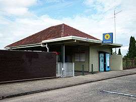
Denistone railway station is on the North Shore, Northern & Western Line of the Sydney Trains network. Denistone is predominantly residential, free of an expedient commercial hub. Its centre is considered to be the railway station, which was built in 1937, extending to Darvall Park. It has been voted the worst station on the T1 North Shore and Northern Lines Facebook page.
Politics
Denistone sits in the state electorate of Ryde whose member is Victor Dominello, and the Federal electorate of Bennelong whose member is John Alexander.
Parks
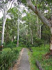
Darvall Park is a forest reserve near the railway line at Denistone. Flora includes Sydney blue gum, red olive berry, orange bark, waddy wood and forest nightshade. Despite over thirty years of bush regeneration, large areas of Darvall Park are heavily infested with weeds. Privet, Chinese privet, lantana, Madeira vine, taro and trad. The ringtail possum, Australian king parrot and satin bowerbird are sometimes seen here.
Demographics
Population
At the 2011 census, there were 3,566 residents in Denistone. 64.3% of residents were born in Australia. The most common other countries of birth were China 8.8%, Korea, Republic of (South) 4.2% and England 2.4%. In Denistone 65.5% of people only spoke English at home. Other languages spoken at home included Mandarin 7.5%, Cantonese 7.1% and Korean 4.8%. In Denistone, separate houses were the main dwelling type (85.3%) and only 0.6% of dwellings were flats or apartments.[1]
Income
Median weekly household income is $2145.
Notable people
Arthur Beetson, renown as one of the greatest Australian Rugby League players of all time used to live in Denistone.
References
| Wikimedia Commons has media related to Denistone, New South Wales. |
- 1 2 Australian Bureau of Statistics (27 June 2017). "Denistone (State Suburb)". 2016 Census QuickStats. Retrieved 14 March 2018.

- ↑ The Book of Sydney Suburbs, Compiled by Frances Pollen, Angus & Robertson Publishers, 1990, Published in Australia ISBN 0-207-14495-8, page 83
- ↑ "Hermitage and Garden, New South Wales State Heritage Register (NSW SHR) Number H00777". New South Wales State Heritage Register. Office of Environment and Heritage. Retrieved 18 May 2018.
External links
- Angela Phippen (2010). "Denistone". Dictionary of Sydney. Retrieved 27 September 2015. [CC-By-SA]
Coordinates: 33°48′03″S 151°05′11″E / 33.80085°S 151.08648°E