Getap, Aragatsotn
Coordinates: 40°23′14″N 43°37′18″E / 40.38722°N 43.62167°E
| Getap Գետափ | |
|---|---|
 Getap | |
| Coordinates: 40°23′14″N 43°37′18″E / 40.38722°N 43.62167°E | |
| Country | Armenia |
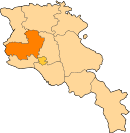
| Marz (Province) | Aragatsotn |
| Population (2001) | |
| • Total | 183 |
| Time zone | UTC+4 ( ) |
| • Summer (DST) | UTC+5 ( ) |
Getap (Armenian: Գետափ, also Romanized as Getap’ and Getar; until 1946, Karakula or Gharaghla[1]) is a town in the Aragatsotn Province of Armenia.
See also
References
- ↑ Kiesling, Rediscovering Armenia, p. 20, available online at the US embassy to Armenia's website Archived June 26, 2008, at the Wayback Machine.
This article is issued from
Wikipedia.
The text is licensed under Creative Commons - Attribution - Sharealike.
Additional terms may apply for the media files.