Aruch
Coordinates: 40°17′15″N 44°04′42″E / 40.28750°N 44.07833°E
| Aruch Արուճ | |
|---|---|
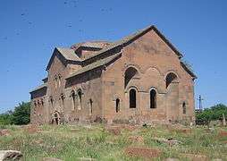 Aruchavank monastery (7th century) | |
 Aruch | |
| Coordinates: 40°17′33″N 44°04′45″E / 40.29250°N 44.07917°E | |
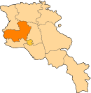
| Country | Armenia |
| Marz (Province) | Aragatsotn |
| Population (2011) | |
| • Total | 1,014 |
| Time zone | UTC+4 ( ) |
Aruch (Armenian: Արուճ; until 1970, Talish), is a village in the Aragatsotn Province of Armenia. It is located on the southern part of Mount Aragats. The settlement dates back to the 6th century when it was the winter camp of the royal army. It was later made to a permanent base by Grigor Mamikonian (661-682). The village is the location of the 7th century Armenian monastic complex Aruchavank, adjacent to it are the remains of the Mamikonians' palace.
See also
References
- Aruch at GEOnet Names Server
- Kiesling, Rediscovering Armenia, pp. 17–18, available online at the US embassy to Armenia's website
- Report of the results of the 2001 Armenian Census, National Statistical Service of the Republic of Armenia
This article is issued from
Wikipedia.
The text is licensed under Creative Commons - Attribution - Sharealike.
Additional terms may apply for the media files.