Byurakan
| Byurakan Բյուրական | |
|---|---|
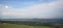 View of Byurakan as seen from the village of Tegher | |
 Byurakan | |
| Coordinates: 40°20′24″N 44°16′13″E / 40.34000°N 44.27028°ECoordinates: 40°20′24″N 44°16′13″E / 40.34000°N 44.27028°E | |
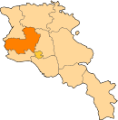
| Country | Armenia |
| Marz (Province) | Aragatsotn |
| Government | |
| • Mayor | Zarzand Babayan |
| Area | |
| • Total | 21.27 km2 (8.21 sq mi) |
| Elevation | 1,460 m (4,790 ft) |
| Population (2011) | |
| • Total | 4,345 |
| Time zone | UTC+4 ( ) |
Byurakan (Armenian: Բյուրական), is a major village in the Aragatsotn Province of Armenia, located on the slope of Mount Aragats. The village is home to several historical sites including the 7th-century Artavazik Church, the 10th-century basilica of Saint Hovhannes and a huge 13th-century khachkar monument.
It is also home to the Byurakan Observatory.
Gallery
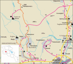 Road map of Byurakan and surrounding region.
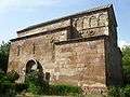 Basilica of S. Hovhannes of the 10th century
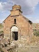 Artavazik Church of the 7th century with huge khachkar monument behind.
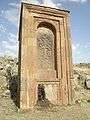 Huge khachkar monument behind Artavazik Church of the 13th century
 Pillar style khachkar with a Maltese Cross located behind a house in the village.
Nearby sites
Towns
Villages
Historical sites
- Amberd fortress
See also
References
- Byurakan at GEOnet Names Server
- World Gazetteer: Armenia – World-Gazetteer.com
- Report of the results of the 2001 Armenian Census
- Kiesling, Rediscovering Armenia, p. 15, available online at the US embassy to Armenia's website
| Authority control |
|---|
This article is issued from
Wikipedia.
The text is licensed under Creative Commons - Attribution - Sharealike.
Additional terms may apply for the media files.