Georgemas Junction railway station
| Georgemas Junction | |
|---|---|
| Scottish Gaelic: Snaidhm Georgemas[1] | |
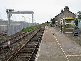 Looking west towards Halkirk village and the line to Thurso (right) | |
| Location | |
| Place | Halkirk |
| Local authority | Highland |
| Coordinates | 58°30′49″N 3°27′06″W / 58.5135°N 3.4518°WCoordinates: 58°30′49″N 3°27′06″W / 58.5135°N 3.4518°W |
| Grid reference | ND155592 |
| Operations | |
| Station code | GGJ |
| Managed by | Abellio ScotRail |
| Number of platforms | 1 |
|
Live arrivals/departures, station information and onward connections from National Rail Enquiries | |
| Annual rail passenger usage* | |
| 2012/13 |
|
| 2013/14 |
|
| 2014/15 |
|
| 2015/16 |
|
| 2016/17 |
|
| History | |
| Original company | Sutherland and Caithness Railway |
| Pre-grouping | Highland Railway |
| Post-grouping |
London, Midland and Scottish Railway British Railways |
| 1874 | Opened |
| National Rail – UK railway stations | |
| * Annual estimated passenger usage based on sales of tickets in stated financial year(s) which end or originate at Georgemas Junction from Office of Rail and Road statistics. Methodology may vary year on year. | |
|
| |
Georgemas Junction railway station is a railway station serving the village of Halkirk and its surrounding areas in the Highland council area, northern Scotland. The station is on the Far North Line, within the historic county of Caithness. Georgemas Junction is the junction of the Thurso branch from the Inverness-Wick line, the most northerly railway junction in Scotland.
History
The station was built by the Sutherland and Caithness Railway (S&CR). The station buildings were designed by Murdoch Paterson and it opened on 28 July 1874[2] and on that date the Highland Railway absorbed the S&CR and operated the newly completed line from Helmsdale to Thurso and Wick. A wrought-iron turntable of 45 feet (14 m) diameter built by the Railway Steel and Plant Company of Manchester was installed at the station.[3]
In 1902, Donald Mackenzie, station master was appointed first station master of Dornoch railway station.[4]
From 1 January 1923 the station was operated by the London Midland and Scottish Railway.
At the end of February 1937 trains were stuck at Georgemas Junction because of heavy snow. A goods train from Inverness got stuck in a drift 9 feet (2.7 m) deep. An engine with a snow plough was also stuck at the same location.[5]
Operation
Until diesel multiple unit trains were introduced by British Rail in the early 1990s, all trains on the Far North Line were locomotive hauled, initially by Highland Railway steam locomotives, then by LMSR steam locomotives and latterly by British Railways steam and finally Class 37 diesel locomotives. Northbound passenger trains would divide at Georgemas Junction, with the rear portion for Thurso and the front portion for Wick. A locomotive was stabled at Georgemas Junction to haul the Thurso carriages.
Following the introduction of Class 156 diesel multiple units on the line, trains were always composed of two trainsets (four cars) and at Georgemas, these would split in half with the front portion heading to Wick, the rear to Thurso.
This practice was halted with the introduction of Class 158 sets which operate as single sets. On arrival at Georgemas Junction from Inverness, trains reverse to reach Thurso, and then reverse again from Thurso back to Georgemas Junction (stopping a second time) and on to Wick. An easement to the National Routeing Guide allows passengers for Wick to stay on the train between Georgemas Junction and Thurso, which would otherwise technically be off-route.[6]
Georgemas Junction station has been used for several freight services. In the early 2000s, EWS operated a freight train for Safeway supermarket, running from Mossend to Georgemas. Containers were unloaded at Georgemas, then transported by road to Wick and Thurso, and by ferry to Orkney.[7]
In 2012, Direct Rail Services constructed a new freight terminal at Georgemas, which led to the removal of the former southbound platform and footbridge. This has been used by trains taking nuclear material from Dounreay to Sellafield.[8]
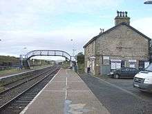
The station is 147 miles 20 chains (237.0 km) from Inverness, and is the zero point for the line to Thurso. It has a single platform which is long enough for a six-coach train.[9]
Services
There are four trains to and from Inverness each weekday - each northbound one travels to Thurso first before returning here and continuing to Wick, before performing the procedure in reverse on each southbound journey (so calling at the station twice per trip). There is one service each way between Inverness & Thurso/Wick on Sundays.[10]
| Preceding station | Following station | |||
|---|---|---|---|---|
| Scotscalder or Forsinard |
Abellio ScotRail Far North Line |
Thurso | ||
| Wick | ||||
| Historical railways | ||||
| Halkirk station closed; line open |
Highland Railway Sutherland and Caithness Railway |
Bower station closed; line open | ||
| Hoy station closed; line open |
||||
References
Notes
- ↑ Brailsford 2017, Gaelic/English Station Index.
- ↑ "The Sunderland and Caithness Railway". The Scotsman. British Newspaper Archive. 27 July 1874. Retrieved 14 August 2016 – via British Newspaper Archive. (Subscription required (help)).
- ↑ "The Sutherland and Caithness Railway". John o’Groat Journal. Scotland. 9 July 1874. Retrieved 15 July 2017 – via British Newspaper Archive. (Subscription required (help)).
- ↑ "Opening of the Dornoch Light Railway". John o’Groat Journal. Scotland. 30 May 1902. Retrieved 30 August 2017 – via British Newspaper Archive. (Subscription required (help)).
- ↑ "Trains delayed". Aberdeen Journal. British Newspaper Archive. 1 March 1937. Retrieved 15 August 2016 – via British Newspaper Archive. (Subscription required (help)).
- ↑ http://www.atoc.org/clientfiles/File/RSPDocuments/easements.pdf
- ↑ "Supermarket containers being unloaded at Georgemas Junction, 2001". Am Baile. Highland Council.
- ↑ "Rail terminal is a major boost". John O'Groat Journal. 27 June 2012. Retrieved 26 February 2013.
- ↑ Brailsford 2017, map 20E.
- ↑ GB eNRT May 2016 Edition, Table 239
Sources
- Brailsford, Martyn, ed. (December 2017) [1987]. Railway Track Diagrams 1: Scotland & Isle of Man (6th ed.). Frome: Trackmaps. ISBN 978-0-9549866-9-8.
- Butt, R. V. J. (1995). The Directory of Railway Stations: details every public and private passenger station, halt, platform and stopping place, past and present (1st ed.). Sparkford: Patrick Stephens Ltd. ISBN 978-1-85260-508-7. OCLC 60251199.
- Jowett, Alan (March 1989). Jowett's Railway Atlas of Great Britain and Ireland: From Pre-Grouping to the Present Day (1st ed.). Sparkford: Patrick Stephens Ltd. ISBN 978-1-85260-086-0. OCLC 22311137.
External links
| Wikimedia Commons has media related to Georgemas Junction railway station. |