Scotscalder railway station
| Scotscalder | |
|---|---|
| Scottish Gaelic: Caladal nan Gall[1] | |
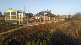 Scotscalder railway station looking east towards Georgemas Junction and Wick. | |
| Location | |
| Place | Scotscalder |
| Local authority | Highland |
| Coordinates | 58°28′58″N 3°33′08″W / 58.4829°N 3.5521°WCoordinates: 58°28′58″N 3°33′08″W / 58.4829°N 3.5521°W |
| Grid reference | ND096560 |
| Operations | |
| Station code | SCT |
| Managed by | Abellio ScotRail |
| Number of platforms | 1 |
|
Live arrivals/departures, station information and onward connections from National Rail Enquiries | |
| Annual rail passenger usage* | |
| 2012/13 |
|
| 2013/14 |
|
| 2014/15 |
|
| 2015/16 |
|
| 2016/17 |
|
| History | |
| Original company | Sutherland and Caithness Railway |
| Pre-grouping | Highland Railway |
| Post-grouping | LMS |
| 28 July 1874[2] | Open |
| National Rail – UK railway stations | |
| * Annual estimated passenger usage based on sales of tickets in stated financial year(s) which end or originate at Scotscalder from Office of Rail and Road statistics. Methodology may vary year on year. | |
|
| |
Scotscalder railway station is a railway station serving the villages of Scotscalder, Olrigmore, Calder, Westerdale and outlying areas. The area falls into the Highland council area, in the north of Scotland.
History
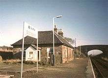
The station was opened by the Sutherland and Caithness Railway on 28 July 1874.[2][3] In 1988 the station house was sold by the British Railways Board for conversion to a residential dwelling. Following the conversion, in 1994, the station house was sold again and renovated further for which the owner won the Ian Allan Railway Heritage Award. The station house was used as a holiday home during this period, but was available to rent for short periods. It was also occasionally open to the public for viewings. Between 1994 and 2004, the owner purchased additional land to the North and South of the station house to prevent development.
In 2004 the station house and surrounding land was sold again to the present owners who have carried out extensive refurbishment. The station house is now a private residence and is no longer available to rent or open to the public.
The station is 143 miles 2 chains (230.2 km) from Inverness, and has a single platform which is long enough for a four-coach train.[4]
Services
The station is located on the Far North Line, within the county of Caithness. Together with Georgemas Junction, the station serves the local communities.
This station is designated as a 'request stop'. This means that passengers intending to alight must inform the guard in advance, and any passengers wishing to board must ensure they are in view of the train driver, and are required to use a hand signal to stop the train.
Due to its remoteness, limited services and lengthy journey times, Scotscalder has a low patronage. As of the 2016-17 statistics, it is the 20th least used railway station in the United Kingdom, and the 2nd least used station on the Far North Line. In the May 2017 timetable, there are four trains north to Wick via Thurso and three south to Inverness from Mon-Sat (if requested). There is a fourth Wick to Inverness service, but this is not advertised to stop at Scotscalder. There is a single train each way on Sundays.[5]
| Preceding station | Following station | |||
|---|---|---|---|---|
| Altnabreac | Abellio ScotRail Far North Line |
Georgemas Junction | ||
| Historical railways | ||||
| Altnabreac Station and Line open |
Highland Railway Sutherland and Caithness Railway |
Halkirk Station closed; Line open | ||
References
Notes
- ↑ Brailsford 2017, Gaelic/English Station Index.
- 1 2 Butt (1995)
- ↑ "The Sunderland and Caithness Railway". The Scotsman. British Newspaper Archive. 27 July 1874. Retrieved 14 August 2016 – via British Newspaper Archive. (Subscription required (help)).
- ↑ Brailsford 2017, map 20D.
- ↑ Table 239 National Rail timetable, May 2017
Sources
- Brailsford, Martyn, ed. (December 2017) [1987]. Railway Track Diagrams 1: Scotland & Isle of Man (6th ed.). Frome: Trackmaps. ISBN 978-0-9549866-9-8.
- Butt, R. V. J. (1995). The Directory of Railway Stations: details every public and private passenger station, halt, platform and stopping place, past and present (1st ed.). Sparkford: Patrick Stephens Ltd. ISBN 978-1-85260-508-7. OCLC 60251199.
- Jowett, Alan (March 1989). Jowett's Railway Atlas of Great Britain and Ireland: From Pre-Grouping to the Present Day (1st ed.). Sparkford: Patrick Stephens Ltd. ISBN 978-1-85260-086-0. OCLC 22311137.
- Jowett, Alan (2000). Jowett's Nationalised Railway Atlas (1st ed.). Penryn, Cornwall: Atlantic Transport Publishers. ISBN 978-0-906899-99-1. OCLC 228266687.
External links