George Rogers Clark Memorial Bridge
| George Rogers Clark Memorial Bridge | |
|---|---|
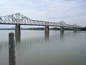 The George Rogers Clark Memorial Bridge as seen from Louisville Waterfront Park | |
| Coordinates | 38°15′49″N 85°45′05″W / 38.26361°N 85.75139°WCoordinates: 38°15′49″N 85°45′05″W / 38.26361°N 85.75139°W |
| Carries |
4 lanes of |
| Crosses | Ohio River |
| Locale | Louisville, Kentucky and Jeffersonville, Indiana |
| Maintained by | KYTC |
| Characteristics | |
| Design | Cantilever bridge |
| Total length | 5,746.5 ft (1,751.5 m) |
| Width | 38.0 ft (11.6 m) |
| Longest span | 819.6 ft (249.8 m) |
| History | |
| Opened | 1929 |
|
Louisville Municipal Bridge, Pylons and Administration Building | |
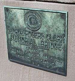 Dedication plaque on the bridge | |
  | |
| Location | Spans Ohio River between Louisville, KY and Jeffersonville, IN, Louisville, Kentucky |
|---|---|
| Area | 5 acres (2.0 ha) |
| Built | 1928 |
| Architect | Multiple |
| Architectural style | Art Deco, Warren through truss |
| NRHP reference # | 84001578[1] |
| Added to NRHP | March 8, 1984 |
The George Rogers Clark Memorial Bridge is a four-lane cantilevered truss bridge crossing the Ohio River between Louisville, Kentucky and Jeffersonville, Indiana, that carries US 31. It is known locally as the Second Street Bridge.
History
It was designed by Ralph Modjeski and Frank Masters with architectural details handled by Paul Philippe Cret of Philadelphia, and construction began in June 1928 by the American Bridge Company of Pittsburgh at a cost of $4.7 million. President Herbert Hoover dedicated the bridge.[2] It was opened to the public on October 31, 1929 as the Louisville Municipal Bridge and operated as a toll bridge. The toll was 35 cents until December 31, 1936, when it became a quarter. The last of the bonds that financed the construction were redeemed in 1946, and the tolls were removed.[3]
On January 17, 1949, the bridge was renamed in honor of George Rogers Clark, recognized as the founder of Louisville.[4]
The bridge was rehabilitated in 1958.
Muhammad Ali threw his gold medal from the 1960 Rome Olympics into the Ohio river while standing on the bridge.
There was a movement in the 1950s to restore tolls, as traffic on the bridge had reached capacity and funding was needed for an additional bridge, but a toll was opposed strongly by most residents. Ultimately most of the funds for two additional bridges (for motor vehicles only) that carry interstate highways came from the federal government.
It was placed on the National Register of Historic Places on March 8, 1984, as the Louisville Municipal Bridge, Pylons and Administration Building.[1]
In June 2010, Kentucky Governor Steve Beshear and Louisville Mayor Jerry Abramson announced a new $3 million streetscape improvement project directly underneath the Clark Memorial Bridge, a three-block area from Main Street to River Road, which will be transformed into a plaza. This includes a new decorative lighting system under the refurbished Clark Memorial Bridge, wide sidewalks, seats, new pedestrian and festival areas, and extensive plantings, making this an inviting promenade for the new KFC Yum! Center. The project was completed in time for the October 2010 opening of the arena.[5] CARMAN provided the landscape architecture and civil engineering services for the 2010 streetscape project.
The bridge was expected to see significant increases in traffic following the completion of the Ohio River Bridges Project near the end of 2016. The project included repurposing the John F. Kennedy Memorial Bridge, which previously carried I-65 in both directions, for southbound traffic only; building the new Abraham Lincoln Bridge for northbound I-65 traffic; and building the Lewis and Clark Bridge to connect I-265 in the two states. The two I-65 crossings and the I-265 bridge are now tolled to pay for the project. One consultant who worked on a transportation study for the Kentucky government predicted that traffic on the bridge would increase by 25% once tolling on the other bridges started, and the mayor of Jeffersonville expressed concern about the possible effects of increased traffic on the bridge's structural integrity. These concerns were heightened by the discovery of a cracked girder and other structural issues (since repaired) during a routine 2014 inspection.[6]
Culture
Locally, the Clark Bridge is known as the Second Street Bridge due to its direct alignment onto Second Street in Louisville. There is a pedestrian sidewalk on each side of the bridge deck. The Clark Bridge was previously the only regional Ohio River bridge open to non-motorized traffic, until the opening of the Indiana side of the nearby Big Four Bridge to pedestrian and bicycle traffic in May 2014.[7][8][9]
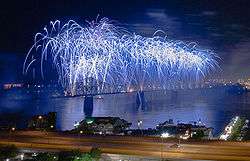
Since 1991, the bridge has been used as "ground zero" for the annual Thunder Over Louisville event, when a waterfall of fireworks flows along the entire length of the bridge during the fireworks show. This involves traffic being closed for much of the week. This is criticized as it cuts off both the only non-interstate and, prior to the Big Four Bridge reopening, the only pedestrian route between Louisville and southern Indiana, which can impact local businesses such as bicycle couriers. Future closures of the Clark Bridge will also cut off the only free vehicular crossing of the Ohio in downtown Louisville.
The bridge is featured in a scene from the 1981 movie Stripes in which Bill Murray drives his cab to the middle of the span, gets out of the vehicle and then tosses his keys into the river below.[10]
See also
References
- 1 2 National Park Service (2010-07-09). "National Register Information System". National Register of Historic Places. National Park Service.
- ↑ "Steve Shaw, Bridges Authority's financing plan not much of a financing plan, LEO Weekly, October 8, 2010". Archived from the original on 11 November 2013. Retrieved 19 October 2014.
- ↑ "Indiana State Historic Architectural and Archaeological Research Database (SHAARD)" (Searchable database). Department of Natural Resources, Division of Historic Preservation and Archaeology. Retrieved 2015-08-01. Note: This includes M.A. Allgeier (October 1983). "National Register of Historic Places Inventory Nomination Form: Louisville Municipal Bridge, Pylons and Administration Building" (PDF). Retrieved 2015-08-01. and Accompanying photographs.
- ↑ Luhan, p. 105
- ↑ "Second Street Transformation to Occur Near arena". Archived from the original on 2010-06-09.
- ↑ Sutter, Chris (November 17, 2016). "Many fear un-tolled bridges will wear quickly due to increased traffic". Louisville: WDRB. Retrieved November 18, 2016.
- ↑ "New Funds Will Complete Big Four Bridge Project". Archived from the original on 2011-07-21.
- ↑ "Emergency crews prep for Big Four Bridge opening". WDRB. December 14, 2012. Archived from the original on December 17, 2012. Retrieved January 21, 2013.
- ↑ "Big Four Bridge path now open from Jeff to Louisville". The Courier-Journal. May 21, 2014. Retrieved May 28, 2014.
- ↑ "Second Street to Third Street". Archived from the original on 2012-07-11. Retrieved 2007-02-22.
- Allgeier, M.A. (1983). Louisville Municipal Bridge, Pylons, and Administrative Building. Louisville, KY: Louisville Landmarks Commission.
- "Automobile Bridges". The Encyclopedia of Louisville (1 ed.). 2001.
- Luhan, Gregory A. (2004). Louisville Guide. Princeton Architectural Press. ISBN 1-56898-451-0.
External links
| Wikimedia Commons has media related to George Rogers Clark Memorial Bridge. |
- Clark Memorial Bridge at Bridges & Tunnels
- Municipal Bridge Building and Pylons at Louisville Art Deco
Bridges of the Ohio River | ||||
|---|---|---|---|---|
| ||||

