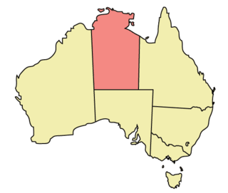
Geography of the Northern Territory
 | |
| Continent | Australia |
|---|---|
| Coordinates | 20°S 133°E / 20°S 133°E |
| Area | Ranked 3rd among states and territories |
| • Total | 1,364,000 km2 (527,000 sq mi) |
| Coastline | 10,953 km (6,806 mi) |
| Borders | Land borders: Western Australia, South Australia, Queensland |
| Highest point |
Mount Zeil 1,531 m (5021 ft) |
| Longest river |
Victoria River 560 km (348 mi) |
| Largest lake |
Lake Amadeus 1032 km² |
Northern Territory borders
The Northern Territory (NT) occupies the north central part of the continent of Australia. The Northern Territory borders are to the west with Western Australia, the Western Australia border being near the 129° east longitude (129° east). The NT to the south with the South Australian border being the 26th parallel south latitude (26° south). To the east the NT with the Queensland border along the 138° east longitude (138° east).
Coastal Boundaries
In the Top End of the Territory is a 5500 km coastline, extending from the Joseph Bonaparte Gulf Timor Sea in the west to the Gulf of Carpentaria in the east. The various islands make up another 5500 km of coastline, resulting in a total of almost 11,000 km.[1]
The southern part of the Territory (Central Australia) is extremely arid. Alice Springs and the surrounding communities make the total population of Central Australia around 60,000 people. There are also large Cattle Stations and significant areas protected around the area. Major transportation in Central Australia mainly comes from road and rail. There are many very small settlements scattered across the Territory but the larger population centres are located on the single sealed road that links Darwin to southern Australia, the Stuart Highway, known to locals simply as "the track".
Geographical features
The coastline in the Top End includes three of Australia's largest islands, Groote Eylandt, Bathurst Island and the largest, Melville Island. The highest point in the Territory is Mount Zeil at 1,531 metres (5021.68 ft) and is situated in the MacDonnell Ranges.[2] In the northern part of the territory lies Kakadu National Park, that features wetlands and native wildlife. To the north of that is the Arafura Sea, and to the east Arnhem Land, whose regional centre is Maningrida on the Liverpool River delta.
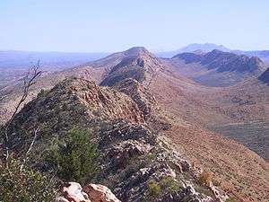
Much of the Territory is relatively flat, but has some disconnected ranges, including the sandstone plateau of western Arnhem Land. Long mountain ranges are more a feature of Central Australia, these include the MacDonnell Ranges, the Petermann Ranges, and Harts Range. The Northern Territory also has the natural rock formations of Uluru and Kata Tjuta, which are sacred to the local Aboriginal people.
The Northern Territory has the two largest deserts in Australia, the Tanami Desert (184,500km)2 in the northern part of the Territory, and the Simpson Desert (176,500km)2 of Central Australia.[3]
There is a series of river systems in the Northern Territory that include Alligator Rivers, Daly River, Finke River, McArthur River, Roper River, Todd River and Victoria River. The Victoria River is the longest river in the Northern Territory and flows for 560 kilometres (348 mi).[4] The longest permanent river in the Northern Territory is the single but doubly named Katherine/Daly river at 690km in total length.
References
- ↑ Geoscience Australia: Border Lengths - States and Territories. Accessed 6 March 2016.
- ↑ "Highest Mountains". Geoscience Australia. Archived from the original on 6 April 2010. Retrieved 22 May 2010.
- ↑ "Deserts". Geoscience Australia. Archived from the original on 5 December 2009. Retrieved 22 May 2010.
- ↑ "Longest Rivers". Geoscience Australia. Archived from the original on 16 May 2010. Retrieved 22 May 2010.
| Topics | ||
|---|---|---|
| Regions | ||
| Major settlements | ||
Northern Territory portal | ||