Geography of the Cayman Islands
 | |
| Continent | — |
|---|---|
| Region |
Central America Caribbean Sea |
| Coordinates | 19°30'N, 80°30'W |
| Area | Ranked 205th |
| • Total | 264 km2 (102 sq mi) |
| • Land | 100% |
| • Water | 0% |
| Coastline | 160 km (99 mi) |
| Borders |
Total land borders: 0 km (0 miles) |
| Highest point |
The Bluff 43 m (141.08 ft) |
| Lowest point |
Caribbean Sea 0 m (0 ft) |
| Longest river | — |
| Largest lake | — |
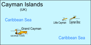
The Cayman Islands are a British dependency and island country. It is a three-island archipelago in the Caribbean Sea, consisting of Grand Cayman, Cayman Brac, and Little Cayman. Georgetown, the capital of the Cayman Islands is 438 km (272 mi) south of Havana, Cuba,[1] and 504 km (313 mi) northwest of Kingston, Jamaica,[2] northeast of Costa Rica, north of Panama and are between Cuba and Central America. Georgetown’s geographic coordinates are 19.300° north, 81.383° west.[2]
The Cayman Islands have a land area of 264 km2 (102 sq mi) approximately 1.5 times the size of Washington, D.C. and just 3 km2 (1.2 sq mi) larger than Saint Kitts and Nevis. The Cayman Islands have a coastline of 160 km (99 mi). The Cayman Islands make a maritime claim of a 200-nautical-mile (370.4 km; 230.2 mi) exclusive fishing zone and a territorial sea of 12 nautical miles (22.2 km; 13.8 mi).[3][4]
Geology
The islands are located on the Cayman Rise which forms the northern margin of the Cayman Trough. The trough is the deepest point in the Caribbean Sea and forms part of the tectonic boundary between the North American Plate and the Caribbean Plate. The Cayman Rise extends from southeastern Cuba along the northern margin of the Cayman Trough toward Costa Rica and resulted from Paleocene to Eocene island arc formation with associated volcanism along an extinct subduction zone.[5] The islands are formed of marine limestone and dolostone that was uplifted during the late Miocene epoch.[6] Due to the Islands' location, the Cayman Islands do get earthquakes.
Climate
The Cayman Islands have a tropical wet and dry climate, with a wet season from May to October, and a dry season that runs from November to April. Terrain is mostly a low-lying limestone base surrounded by coral reefs.
Besides earthquakes another major natural hazard is the tropical cyclones that form during the Atlantic hurricane season from July to November.
| Climate data for George Town (Owen Roberts International Airport) 1981–2010, extremes 1971–2013 | |||||||||||||
|---|---|---|---|---|---|---|---|---|---|---|---|---|---|
| Month | Jan | Feb | Mar | Apr | May | Jun | Jul | Aug | Sep | Oct | Nov | Dec | Year |
| Record high °C (°F) | 32.2 (90.0) |
31.7 (89.0) |
32.2 (90.0) |
32.8 (91.0) |
33.9 (93.0) |
34.4 (94.0) |
34.4 (94.0) |
35 (95.0) |
34.4 (94.0) |
33.6 (92.4) |
32.8 (91.0) |
32.2 (90.0) |
35 (95.0) |
| Average high °C (°F) | 28.2 (82.8) |
28.6 (83.4) |
29.1 (84.3) |
29.9 (85.9) |
30.7 (87.3) |
31.6 (88.9) |
32.2 (89.9) |
32.2 (89.9) |
31.7 (89.0) |
31 (87.8) |
29.6 (85.2) |
28.6 (83.5) |
30.3 (86.5) |
| Daily mean °C (°F) | 25.8 (78.4) |
26.1 (79.0) |
26.6 (79.9) |
27.6 (81.7) |
28.5 (83.3) |
29.2 (84.6) |
29.6 (85.3) |
29.7 (85.5) |
29.3 (84.7) |
28.5 (83.3) |
27.5 (81.5) |
26.2 (79.2) |
27.9 (82.2) |
| Average low °C (°F) | 22.3 (72.2) |
22.4 (72.3) |
22.7 (72.9) |
23.7 (74.6) |
24.7 (76.4) |
25.5 (77.9) |
25.7 (78.2) |
25.6 (78.0) |
25.3 (77.6) |
24.7 (76.5) |
24.1 (75.4) |
23.2 (73.8) |
24.2 (75.5) |
| Record low °C (°F) | 15 (59.0) |
15 (59.0) |
16.1 (61.0) |
16.7 (62.0) |
17.2 (63.0) |
21.7 (71.0) |
20.6 (69.0) |
20 (68.0) |
21.1 (70.0) |
21.1 (70.0) |
18 (64.4) |
14.1 (57.3) |
14.1 (57.3) |
| Average rainfall mm (inches) | 51.8 (2.04) |
38.1 (1.50) |
33.5 (1.32) |
32.3 (1.27) |
151.4 (5.96) |
157.5 (6.20) |
146.8 (5.78) |
149.9 (5.90) |
222 (8.74) |
219.7 (8.65) |
153.7 (6.05) |
70.9 (2.79) |
1,427.5 (56.2) |
| Average relative humidity (%) | 76 | 76 | 75 | 75 | 77 | 78 | 77 | 78 | 79 | 79 | 78 | 78 | 77 |
| Source: National Weather Service (Cayman Islands)[7] | |||||||||||||
Environmental issues
An important environmental issue is the lack of fresh water resources. Drinking water supplies must be met by rainwater catchment and desalination. In addition there is also a problem with trash washing up on the beaches or being deposited by there by residents. The Cayman Islands have no recycling or waste treatment facilities.[8]
Natural resources

Natural resources include fish and a climate and beaches that foster tourism, which is the islands' major industry. A 2012 estimate of land use determined that the Cayman Islands' had 0.83 percent arable land and 2.08 percent permanent crops.
Districts
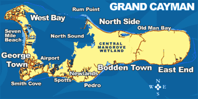
The territory is subdivided into six districts that are governed by district managers and that have a role as electoral districts and as regional units for statistics. Five of the districts are located on the main island, Grand Cayman. The sixth, Sister Islands, comprises the islands of Little Cayman and Cayman Brac.
| Nr. | District or island | Area (km²) | Pop. 1999-10-10 | Pop. 2007 est. | Pop.- density |
|---|---|---|---|---|---|
| 1 | Bodden Town | 5,764 | 6,918 | 865 | |
| 2 | Cayman Brac | 36 | 1,822 | 1,500 | 42 |
| 3 | East End | 50 | 1,371 | 1,552 | 31 |
| 4 | George Town | 29 | 20,626 | 31,785 | 1096 |
| 5 | Little Cayman | 26 | 115 | 200 | 8 |
| 6 | North Side | 1,079 | 1,258 | 14 | |
| 7 | West Bay | 19 | 8,243 | 11,436 | 602 |
| Cayman Islands | 259 | 39,020 | 54.649 | 211 |
The population is concentrated in the three (south-)western districts George Town (capital), West Bay, and Bodden Town. Those have a population density many times higher than all remaining districts.
References
- ↑ "coordinates and total distance". web page. webcrow. Archived from the original on 25 April 2012. Retrieved 23 October 2011.
- 1 2 "coordinates and total distance". web page. webcrow. Archived from the original on 4 January 2012. Retrieved 23 October 2011.
- ↑ "Central Intelligence Agency The World Factbook Cayman Islands". web page. US Central Intelligence Agency. Archived from the original on 17 October 2011. Retrieved 23 October 2011.
- ↑ "Central Intelligence Agency The World Factbook St Kitts and Nevis". web page. US Central Intelligence Agency. Archived from the original on 17 October 2011. Retrieved 23 October 2011.
- ↑ H. Sigurdsson, et al., History of circum-Caribbean explosive volcanism: 40Ar/39Ar dating of tephra layers, Ch. 20 in Volume 165, Proceedings of the Oceanic Drilling Program, 26 May 2000, ISSN 1096-7451 Archived 27 September 2011 at the Wayback Machine. doi:10.2973/odp.proc.sr.165.2000
- ↑ J.E. Davies and M.A. Brunt (1994), "Scientific Studies in the Cayman Islands", in: The Cayman Islands: Natural History and Biogeography, Volume 71, edited by M. A. Brunt. Springer. p. 1. ISBN 9780792324621.
- ↑ "Cayman Data Table". Meteorological Service (Jamaica). Archived from the original on 23 September 2016. Retrieved 22 September 2016.
- ↑ "1,100 pounds of garbage plucked from beach - Cayman Compass". www.caymancompass.com. Archived from the original on 17 January 2018. Retrieved 23 April 2018.
External links
| Wikimedia Commons has media related to Geography of the Cayman Islands. |
- Districts of Cayman Islands, Statoids.com
- Cayman vents are world's hottest (BBC News, 10 January 2012)
- Cayman Islands Land
| Sovereign states |  | |
|---|---|---|
Dependencies and other territories | ||