The Quebec territory.
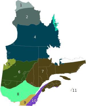
Approximate areas of
ecoregions 1. Middle Arctic Tundra
2. Low Arctic Tundra
3. Torngat Mountain Tundra
4. Eastern Canadian Shield Taiga
5. Southern Hudson Bay Taiga
6. Central Canadian Shield Forests
7. Eastern Canadian Forests
8. Eastern Forest/Boreal Transition
9. Eastern Great Lakes Lowland Forests
10. New England/Acadian Forests
11. Gulf of St. Lawrence Lowland Forests
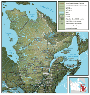
Quebec, Canada's largest province, occupies a vast territory (nearly three times the size of France), most of which is very sparsely populated. With an area of 1,542,056 square kilometres (595,391 square miles), it is the second largest of Canada's provinces and territories and the tenth largest country subdivision in the world. More than 90 percent of Quebec's area lies within the Canadian Shield, and includes the greater part of the Labrador Peninsula. Quebec's highest mountain is Mont D'Iberville, which is located on the border with Newfoundland and Labrador in the northeastern part of the province in the Torngat Mountains. The addition of parts of the vast and scarcely populated District of Ungava of the Northwest Territories between 1898 and 1912 gave the province its current form.
Quebec is bordered by the province of Ontario, James Bay and Hudson Bay (including the circular Nastapoka arc) to the west, the provinces of New Brunswick and Newfoundland and Labrador to the east, the United States (Maine, New Hampshire, Vermont and New York) to the south, and Hudson Strait and Ungava Bay to the north. Its northernmost point is Cape Wolstenholme.
Quebec includes several islands. These include Island of Montreal and Îles Laval, which are parts of the major cities of Montreal and Laval, respectively, Anticosti Island, a sparsely populated island in the outlet of the Saint Lawrence River, and the Magdalen Islands, an archipelago in the Gulf of Saint Lawrence.
In 1927, the border between the Province of Quebec and the Dominion of Newfoundland was delineated by the British Judicial Committee of the Privy Council. The government of Quebec does not officially recognize this boundary. See The Labrador boundary dispute.
The territory of Quebec is extremely rich in resources in its coniferous forests, lakes, and rivers—pulp and paper, lumber, and hydroelectricity are still some of the province's most important industries. The far north of the province, Nunavik, is subarctic or arctic and is mostly inhabited by Inuit.
The most populous region is the Saint Lawrence River valley in the south, where the capital, Quebec City, and the largest city, Montreal, are situated. North of Montreal are the Laurentians, a range of ancient mountains, and to the east are the Appalachian Mountains which extends into the Eastern Townships and Gaspésie regions. The Gaspé Peninsula juts into the Gulf of Saint Lawrence to the East. The Saint Lawrence River Valley is a fertile agricultural region, producing dairy products, fruit, vegetables, maple sugar (Quebec is the world's largest producer), and livestock.
In 1899, the United States claimed Fox Island under the Guano Islands Act of 1856.
Climate
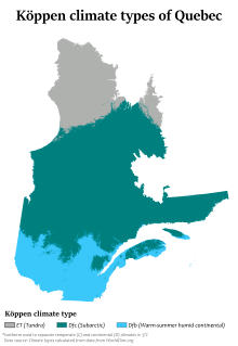
Köppen climate types in Quebec
Quebec has three main climate regions. Southern and western Quebec, including most of the major population centres, have a humid continental climate (Köppen climate classification Dfb) with warm, humid summers and long, cold winters. The main climatic influences are from western and northern Canada which move eastward and from the southern and central United States that move northward. Due to the influence of both storm systems from the core of North America and the Atlantic Ocean, precipitation is abundant throughout the year, with most areas receiving more than 1,000 mm (40 inches) of precipitation, including over 300 cm (120 inches) of snow in many areas. During the summer, severe weather patterns (such as tornadoes and severe thunderstorms) are far less common than in southern Ontario, although they occasionally occur.
Most of central Quebec has a subarctic climate (Köppen Dfc). Winters are long and among the coldest in eastern Canada, while summers are warm but very short due to the higher latitude and the greater influence of Arctic air masses. Precipitation is also somewhat less than farther south, except at some of the higher elevations.
The northern regions of Quebec have an arctic climate (Köppen ET), with very cold winters and short, much cooler summers. The primary influences in this region are the Arctic Ocean currents (such as the Labrador Current) and continental air masses from the High Arctic.
Climate Charts
| Montreal
|
|---|
| Climate chart (explanation) |
|---|
| J | F | M | A | M | J | J | A | S | O | N | D |
|
|
|
|
|
|
|
|
|
|
|
|
| Average max. and min. temperatures in °C |
| Precipitation totals in mm | | Source: [8] |
|
| Imperial conversion |
|---|
| J | F | M | A | M | J | J | A | S | O | N | D |
|
|
|
|
|
|
|
|
|
|
|
|
| Average max. and min. temperatures in °F |
| Precipitation totals in inches |
|
| Quebec City
|
|---|
| Climate chart (explanation) |
|---|
| J | F | M | A | M | J | J | A | S | O | N | D |
|
|
|
|
|
|
|
|
|
|
|
|
| Average max. and min. temperatures in °C |
| Precipitation totals in mm | | Source: [9] |
|
| Imperial conversion |
|---|
| J | F | M | A | M | J | J | A | S | O | N | D |
|
|
|
|
|
|
|
|
|
|
|
|
| Average max. and min. temperatures in °F |
| Precipitation totals in inches |
|
| Trois-Rivières
|
|---|
| Climate chart (explanation) |
|---|
| J | F | M | A | M | J | J | A | S | O | N | D |
|
|
|
|
|
|
|
|
|
|
|
|
| Average max. and min. temperatures in °C |
| Precipitation totals in mm | | Source: [10] |
|
| Imperial conversion |
|---|
| J | F | M | A | M | J | J | A | S | O | N | D |
|
|
|
|
|
|
|
|
|
|
|
|
| Average max. and min. temperatures in °F |
| Precipitation totals in inches |
|
| Baie-Comeau
|
|---|
| Climate chart (explanation) |
|---|
| J | F | M | A | M | J | J | A | S | O | N | D |
|
|
|
|
|
|
|
|
|
|
|
|
| Average max. and min. temperatures in °C |
| Precipitation totals in mm | | Source: [11] |
|
| Imperial conversion |
|---|
| J | F | M | A | M | J | J | A | S | O | N | D |
|
|
|
|
|
|
|
|
|
|
|
|
| Average max. and min. temperatures in °F |
| Precipitation totals in inches |
|
| Sept-Îles
|
|---|
| Climate chart (explanation) |
|---|
| J | F | M | A | M | J | J | A | S | O | N | D |
|
|
|
|
|
|
|
|
|
|
|
|
| Average max. and min. temperatures in °C |
| Precipitation totals in mm | | Source: [12] |
|
| Imperial conversion |
|---|
| J | F | M | A | M | J | J | A | S | O | N | D |
|
|
|
|
|
|
|
|
|
|
|
|
| Average max. and min. temperatures in °F |
| Precipitation totals in inches |
|
| La Grande Riviere
|
|---|
| Climate chart (explanation) |
|---|
| J | F | M | A | M | J | J | A | S | O | N | D |
|
|
|
|
|
|
|
|
|
|
|
|
| Average max. and min. temperatures in °C |
| Precipitation totals in mm | | Source: [13] |
|
| Imperial conversion |
|---|
| J | F | M | A | M | J | J | A | S | O | N | D |
|
|
|
|
|
|
|
|
|
|
|
|
| Average max. and min. temperatures in °F |
| Precipitation totals in inches |
|
| Kuujjuaq
|
|---|
| Climate chart (explanation) |
|---|
| J | F | M | A | M | J | J | A | S | O | N | D |
|
|
|
|
|
|
|
|
|
|
|
|
| Average max. and min. temperatures in °C |
| Precipitation totals in mm | | Source: [14] |
|
| Imperial conversion |
|---|
| J | F | M | A | M | J | J | A | S | O | N | D |
|
|
|
|
|
|
|
|
|
|
|
|
| Average max. and min. temperatures in °F |
| Precipitation totals in inches |
|
References
- 1 2 Ressources Naturelles et Faune - Québec. "Québec's Borders". highligts on the territory - Québec's Borders. Government of Quebec. Archived from the original on August 27, 2011. Retrieved June 21, 2011.
- ↑ VAILLANCOURT, Jacques (May 6, 2009). "Labrador is no longer part of Quebec, Explanations on the situation" (in French). Vigile.net. Retrieved June 25, 2011.
- ↑ Canadian Intergovernmental Affairs Secretariat (October 31, 2001). "The Minister of Natural Resources of Quebec and Minister for Canadian Intergovernmental Affairs express Quebec's position in relation to the constitutional changes in the designation of Newfoundland". Government of Quebec. Archived from the original on April 28, 2005. Retrieved December 10, 2009.
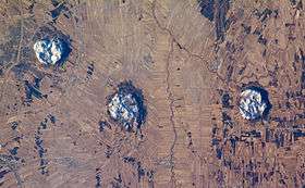
- ↑ Eaton DW, Frederiksen A (March 2007). "Seismic evidence for convection-driven motion of the North American plate". Nature. 446 (7134): 428–431. doi:10.1038/nature05675. PMID 17377580.
FIGURE 2. Inferred track of the Great Meteor hotspot
- 1 2 A Hundred-Million Year History of the Corner Rise and New England Seamounts Retrieved on 2007-08-01
- ↑ The Monteregian Hills: Igneous Intrusions Archived 2009-04-26 at the Wayback Machine., Natural Resources Canada, Geoscape Montreal, 2006-07-24
- ↑ Geology of Gault Nature Reserve, Mont St. Hilaire, McGill University
- ↑ Canadian Climate Normals 1971-2000 (Montreal)
- ↑ Canadian Climate Normals 1971-2000 (Quebec City)
- ↑ Canadian Climate Normals 1971-2000 (Trois Rivieres )
- ↑ Canadian Climate Normals 1971-2000 (Baie-Comeau)
- ↑ Canadian Climate Normals 1971-2000 (Sept-Îles)
- ↑ Canadian Climate Normals 1971-2000 (La Grande Riviere)
- ↑ Canadian Climate Normals 1971-2000 (Kuujjuaq)
- ↑ C. Michael Hogan. 2008. Wild turkey: Meleagris gallopavo, GlobalTwitcher.com, ed. N. Stromberg
|
|---|
| National | |
|---|
| Provinces | |
|---|
| Territories | |
|---|
| See also | |
|---|
 Category Category Portal Portal WikiProject WikiProject
|