Gargallo, Aragon
| Gargallo | |
|---|---|
 | |
 Gargallo | |
| Coordinates: 40°50′N 0°35′W / 40.833°N 0.583°WCoordinates: 40°50′N 0°35′W / 40.833°N 0.583°W | |
| Country | Spain |
| Autonomous community | Aragon |
| Province | Teruel |
| Comarca | Andorra-Sierra de Arcos |
| Area | |
| • Total | 29.97 km2 (11.57 sq mi) |
| Elevation | 941 m (3,087 ft) |
| Population (2004) | |
| • Total | 112 |
| Time zone | UTC+1 (CET) |
| • Summer (DST) | UTC+2 (CEST) |
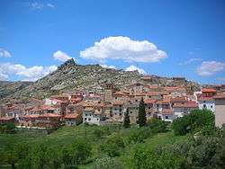
Gargallo is a municipality in Andorra-Sierra de Arcos comarca, province of Teruel, Aragon, Spain. According to the 2010 census the municipality has a population of 140 inhabitants.[1] Its postal code is 44558.
It is located on a rocky ridge of the northern side of Sierra de San Just, part of the vast Iberian System. Road N-211 crosses the southern end of Gargallo.
See also
References
External links
| Wikimedia Commons has media related to Gargallo, Aragon. |
This article is issued from
Wikipedia.
The text is licensed under Creative Commons - Attribution - Sharealike.
Additional terms may apply for the media files.