Gamilaraay
 | |||||||||
| Total population | |||||||||
|---|---|---|---|---|---|---|---|---|---|
| approx. 13,000 | |||||||||
| Regions with significant populations | |||||||||
| Languages | |||||||||
| Gamilaroi language, English and Aboriginal English | |||||||||
| Religion | |||||||||
| Christianity, Traditional | |||||||||
| Related ethnic groups | |||||||||
| Indigenous Australians | |||||||||
.jpg)


The Gamilaraay, also called the Kamilaroi are an Indigenous Australian people whose lands extended from New South Wales to southern Queensland. They form one of the four largest indigenous nations in Australia. The Kamilaroi Highway, Sydney Ferries Limited's vehicular ferry "Kamilaroi" (1901–1933), and a cultivar of Durum wheat have all been named after the Kamilaroi people.[1]
Name
The ethnonym Gamilaraay is formed from gamil, meaning "no", and the suffix -(b)araay, bearing the sense of "having". It is a common practice among Australian tribes to have themselves identified according to their respective words for "no".
Language
Kamilaroi language is classified as one of the Pama–Nyungan languages. The language is no longer spoken, the last fluent speakers dying out in the 1950s. However some parts have been reconstructed by late field work, which includes substantial recordings of the related language, Yuwaalaraay, which continued to be spoken down to the 1980s. Analysing these materials has permitted a good deal of reconstructive work. Robert M. W. Dixon and his student Peter Austin recorded some around Moree, while Corinne Williams wrote a thesis on the Yuwaaliyaay dialect spoken at Walgett and Lightning Ridge.[2]
The Gamilaraay, like many other tribes, taught young men a secret language, called tyake, during their rites of initiation. In these systems, the normal profane terms used in everyday speech had to be substituted with the special mystical vocabulary.[3][4]
See also Gamilaraay language.
Country
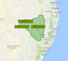
According to Norman Tindale's estimation, the Gamilaraay's tribal domains encompassed some 29,000 square miles (75,000 km2),[5] from around Singleton in the Hunter Valley through to the Warrumbungle Mountains in the west and up through the present-day centres of Quirindi, Gunnedah, Tamworth, Narrabri, Walgett, Moree, Collarenebri, Lightning Ridge and Mungindi in New South Wales, to Nindigully in south west Queensland.
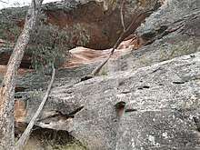
Sandstone Caves
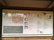
The Sandstone Caves (within the Pilliga Nature Reserve) which is co-managed by the Gamilaraay people together with NPWS.[6] All interpretive signage is in the Gamilaraay language followed by English. A small example, created by the Coonabarabran Gamilaraay Language Circle (Suellen Tighe, Maureen Sutler, Sid Chatfield & Peter Thompson), is given below. (See adjoining image.)[7]
| Nhalay Yarrul Burranbalngayaldanhi Mulamula, nhalay yarrul! |
This rock Water & wind have caused this rock Look out! |
Yilambu Yilambu dhurray marandu Ngamila! |
Long Ago Our ancestors made stone tools. Look out! |
Dhawun Giirr dhulubaraay dhibaraay, Giirr dhamali dhawundu nginunha! |
The land Around here there are plants, Let the land touch you! |
History
The Gamilaroi were hunters and gatherers with a band-level social organization. Important vegetable foods were yams and other roots, as well as a sterculia grain, which was made into a bread. Insect larvae, frogs, and eggs of several different animals were also gathered. Various birds, kangaroos, emus, possums, echidnas, and bandicoots were among the important animals hunted. Dingo pups were regarded as a delicacy. Fish were also consumed, as were crayfish, mussels, and shrimp. Men typically hunted, cleaned, and prepared the game for cooking. Women did the actual cooking, in addition to fishing and gathering. Individual Kamilaroi did not eat animals that were their totems.
The nation was made up of many smaller family groups who had their own parcels of land to sustain them. One of the great Kings of this tribe was "Red Chief", who is buried near Gunnedah. The Kamilaroi were regarded as fierce warriors and there is ample evidence of intertribal warfare. The Northern Gamilaroi people have a strong cultural connection with the Bigambul people, and the tribes met regularly for joint ceremonies at Boobera Lagoon near the present-day town of Goondiwindi.
Dreaming
Kamilaroi tradition includes Baiame, the ancestor or patron god. The Baiame story tells how Baiame came down from the sky to the land, and created rivers, mountains, and forests. He then gave the people their laws of life, traditions, songs, and culture. He also created the first initiation site. This is known as a bora; a place where boys were initiated into manhood. When he had finished, he returned to the sky, and people called him the Sky Hero or All Father or Sky Father. He is said to be married to Birrahgnooloo (Birran-gnulu), who is often identified as an emu, and with whom he has a son Turramūlan.[8] In other stories Turramūlan is said to be brother to Baiame. It was forbidden to mention or talk about the name of Baiame publicly. Women were not allowed to see drawings of Baiame nor approach Baiame sites,[8] which are often male initiation sites (boras). Women were instead instructed by Turramūlan's sister, Muni Burribian. In rock paintings Baiame is often depicted as a human figure with a large head-dress or hairstyle, with lines of footsteps nearby. He is always painted in front view; Turramūlan is drawn in profile. Baiame is often shown with internal decorations such as waistbands, vertical lines running down the body, bands and dots.
In Gamilaraay star-lore myth it is recounted that Orion, known as Berriberri[lower-alpha 2] set out in pursuit of the Pleiades (Miai-miai) and cornered them in a mother-tree where they were transformed into yellow and white cockatoos. His attempts to capture them were blocked by Turramūlan, a one-eyed, one-legged legendary figure associated with the Pole star.[9] They called Orion's Belt, ghūtūr,[8] a girdle that covered his invincible boomerang.(burran)[10][8] The seventh of Miai-miai, being less beautiful, was shy (gurri gurri)and afraid and she was thus transformed into the least visible of the 7 Pleiades.[8]
Rite of Initiation
The rite of passage whereby Gamilaraay youths are inducted by initiation into full membership of the tribe were conducted at a Bora ceremony on a bora site especially prepared for the occasion. Tribes ready to participate in such rituals are contacted, and the ceremonies lasted several days.
The major bora, called Baiame's ground, was cleared on loamy umah soil, roughly 75 feet in diameter, with the scraped earth used to created an embanked ring about 8-9 inches high to fence off the sacred space,[11] apart from one opening which led into a thunburran or narrows pathway that ran some 270 yards off to a smaller circle, some 47 feet in diameter, called a goonaba, constructed in a similar fashion,[12] Inside this ring two stumps (warrengahlee) formed from uprooted trees, one a coolabah the other a belar, trimmed and turned upside down so that the roots, decorated with twists of bark, flared out.
The pathway leading novices from the larger to the smaller circle was adorned with yammunyamun, figures cut into the exposed sapwood of trees along the route, or drawn on the ground. On the occasion observed by Mathews, on the right hand side, 90 yards down the track, was a mocked up bowerbird's nest, and 3 yards further on a scarecrow figure with trousers and jacket stuffed with grass, representing a whiteman. As the youths passed along this track, the significance of the symbols and their relevance to tribal beliefs was explained.[13][14] Further down the path, a yammunyamun image of a bullock was formed from bark, dirt and the animal's skull. At 143 yards, a 9 foot long representation of Baiame and his spouse Gooberangal lay, moulded from the earth, respectively on the right and left of the track.[15] Further on, still on the left, was a carved figure of the Emu,[lower-alpha 3] apparently crouching, its head pointed towards the large bora. To its right, a further three yards on, was Goomee, Baiame's fire, a foot high mound with a lit fire on top. A further 18 yards on, parallel to the track and on Goomee's side, a codfish was depicted, and after it the Currea, a serpentine creature, and, 15 yards on the other side of the path, two death adders, followed then by a turkey's nest, an earth-stuffed porcupine's skin, and a kangaroo rat's nest. At last, there was a carving of a full tribal man on one side of the track, and an aboriginal woman on the other.[17]
Notable Gamilaroi people
Traditional leaders
Modern Gamilaraay
- Richard Bell - contemporary artist and co-founder artist collective PROPPA NOW
- Greg Bird – NRL player for Gold Coast Titans
- Con Colleano – tightrope walker
- Adam Giles - former politician and former Chief Minister of the Northern Territory
- Jason Gillespie – Australian Test cricketer
- Bert Groves - Civil rights leader[18]
- Cameron Hammond – Professional Boxer who Won the WBA Oceania welterweight, WBC Eurasia Pacific Boxing Council welterweight titles
- Damien Hooper – Professional Boxer who Won the WBC Youth Silver light heavyweight, WBC Eurasia Pacific Boxing Council light heavyweight, IBF International light heavyweight & WBO International light heavyweight titles
- Ben Jones – NRL player for Sydney Roosters in 2013 via their reserve grade team Newtown Jets
- Mundara Koorang – Artist, designer, teacher, elder, actor, and author
- Michael Lett – NRL player
- Nakkiah Lui - writer, actor, director
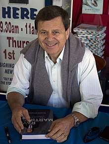
- Ray Martin – TV Presenter
- Tracey Moffatt - contemporary artist, represented Australia at the Venice Biennale, 2017
- Thelma Plum – Folk Singer/Songwriter
- George Rose – NRL player for Manly Sea Eagles
- Charles Samuels - athlete[19]
- Dale Shearer – Former NRL player for Manly-Warringah, Widnes, Brisbane Broncos, Gold Coast Seagulls, Sth. Qld. Crushers, Sydney Roosters, Nth. Qld. Cowboys & Queensland and Australian Rugby League player
- Brad Tighe – NRL PLayer for Penrith Panthers
- Luke Walsh – NRL PLayer for Penrith Panthers
- Megan Wilding - actor, writer[20]
- Jonathan Wright – NRL player for Cronulla Sutherland Sharks
Alternative spellings
- Kamilarai, Kamilari, Kamilroi, Kamilarai, Kamularoi, Kaamee'larrai, Kamileroi
- Koomilroi, Komleroy
- Gamilaroi, Gamilroi
- Kahmilaharoy, Kamilary
- Gumilroi, Gummilroi, Gummilray, Ghummilarai
- Kimilari, Karmil, Kamil, Kahml
- Comleroy
- Ghummilarai, Cammealroy, Kahmilari
- Cumilri, Camelleri, Cummilroy, Comleroy, Cummeroy
- Gunnilaroi
- Cammealroy
- Duhai
- Yauan
- Tjake, Tyake[5]
Some words
- bundar. (kangaroo)
- buruma. (dog).[lower-alpha 4]
See also
Notes
- ↑ This map is not authoritative.
- ↑ Greenway states that the term means "young men".[8]
- ↑ According to a recent study of Kamilaroi cosmological lore, for them "the appearance of the Emu began at the Coalsack under the star α Crucis, which formed the Emu's head, then β and α Centauri, which form the start of the neck, down the dust lanes of the Milky Way to η Lupus and γ2 Norma, at which point the dust lanes expand with the body of the Emu, reaching the maximum thickness with ε Scorpii and λ Scorpii, and tapering towards 36-Ophiuchi and 3-Sagittarii, eventually ending near μ Sagittarii."[16]
- ↑ In ritual speech these terms were substituted respectively with the corresponding sacred words, ungogirgal, and gungumoal, for example.[3]
Citations
- ↑ Bellata Gold.
- ↑ Dixon 2011, p. 218.
- 1 2 Mathews 1902, p. 159.
- ↑ Tindale 1974, p. 195.
- 1 2 Tindale 1974, p. 194.
- ↑ "Pilliga Nature Reserve: Plan of Management". Retrieved 9 May 2018.
- ↑ Tighe, S., Sutler, M., Chatfield, S., Thompson, P. & National Parks & Wildlife Service. Notice Board at entrance to Sandstone Caves walk (observed 8 May 2018)
- 1 2 3 4 5 6 Greenway 1878, p. 243.
- ↑ Hewitt 1901, p. 90.
- ↑ Greenway 1901b, p. 168.
- ↑ Mathews 1897, p. 142.
- ↑ Mathews 1897, p. 143.
- ↑ Purcell 2011, p. 4.
- ↑ Mathews 1897, p. 138.
- ↑ Mathews 1897, p. 144.
- ↑ Fuller et al. 2014, pp. 174–175.
- ↑ Mathews 1897, pp. 145–146.
- ↑ Duncan, A.T. (1996) "Groves, Herbert Stanley (Bert) (1907–1970)". Australian dictionary of Biography. M.U.P.
- ↑ "Charles Samuels (1864-1912)". Australian Dictionary of Biography.
- ↑ "The Balnaves Award Winner". Belvoir.
Sources
- "Bellata Gold". Archived from the original on 22 March 2006. Retrieved 21 April 2006.
- Dixon, R. M. W. (2002). Australian Languages: Their Nature and Development. Cambridge University Press. ISBN 978-0-521-47378-1.
- Dixon, R. M. W. (2011). Searching for Aboriginal Languages: Memoirs of a Field Worker. Cambridge University Press. ISBN 978-1-108-02504-1.
- Fison, Lorimer; Howitt, Alfred William (1880). Kamilaroi and Kurnai (PDF). Melbourne: G Robinson.
- Fuller, Robert S.; Anderson, Michael G.; Norris, Ray P.; Trudgett, Michelle (2014). "The Emu Sky Knowledge of the Kamilaroi and Euahlayi Peoples". Journal of Astronomical History and Heritage. 17 (2): 171–179.
- Greenway, C. C. (22 November 1901b). "Berryberry, aboriginal myth". Science of Man. 4 (10): 168.
- Greenway, Charles C. (1878). "Kamilaroi language and Traditions". The Journal of the Anthropological Institute of Great Britain and Ireland. 7: 232–274. JSTOR 2841001.
- Greenway, Charles C. (21 August 1901a). "Borah, "boohra," or "boorhung."". Science of Man. 4 (7): 117–118.
- Hewitt, James Francis Katherinus (1901). History and chronology of the myth-making age (PDF). J. Parker and Co.
- Howitt, Alfred William (1904). The native tribes of south-east Australia (PDF). Macmillan.
- Mathews, R. H. (1897). "The Bora of the Kamilaroi Tribes". Proceedings of the Royal Society of Victoria. 9: 137–173.
- Mathews, R. H. (1902). "Languages of some native tribes of Queensland, New South Wales, and Victoria". Proceedings of the Royal Society of New South Wales. 36: 135–190, 154–159.
- McCarthy, Frederick D. (1 June 1940). "The Carved Trees of New South Wales" (PDF). Australian Museum Magazine. pp. 161–166.
- Purcell, Leigh (2011). Cumming, Helen, ed. Carved Trees: Aboriginal cultures of western NSW, Gamilaroi Country (PDF). State Library of New South Wales. ISBN 0 7313 7206 9.
- Tindale, Norman Barnett (1974). "Kamilaroi (NSW)". Aboriginal Tribes of Australia: Their Terrain, Environmental Controls, Distribution, Limits, and Proper Names. Australian National University.