Gamaliel, Arkansas
| Gamaliel, Arkansas | |
|---|---|
| Unincorporated community | |
 Gamaliel, Arkansas  Gamaliel, Arkansas | |
| Coordinates: 36°27′24″N 92°14′00″W / 36.45667°N 92.23333°WCoordinates: 36°27′24″N 92°14′00″W / 36.45667°N 92.23333°W | |
| Country | United States |
| State | Arkansas |
| County | Baxter |
| Elevation | 902 ft (275 m) |
| Time zone | UTC-6 (Central (CST)) |
| • Summer (DST) | UTC-5 (CDT) |
| ZIP code | 72537 |
| Area code(s) | 870 |
| GNIS feature ID | 57790[1] |
Gamaliel is an unincorporated community in Baxter County, Arkansas, United States. Gamaliel is located along Arkansas Highway 101, 12 miles (19 km) northeast of Mountain Home and 3 mi (4.8 km) south of the Arkansas—Missouri border. Gamaliel has a post office with ZIP code 72537.[2]
Gamaliel is located on a ridge between Bennetts Bayou to the east and the Norfork River/Norfork Lake to the west. Gamaliel campground on the east arm of Norfork Lake is about three miles to the southeast.[3]
References
- ↑ U.S. Geological Survey Geographic Names Information System: Gamaliel, Arkansas
- ↑ ZIP Code Lookup
- ↑ Arkansas Atlas & Gazetteer, DeLorme, 2004, 2nd edition, p. 26, ISBN 0-89933-345-1
Municipalities and communities of Baxter County, Arkansas, United States | ||
|---|---|---|
| Cities | 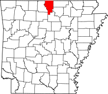 | |
| Towns | ||
| CDP | ||
| Unincorporated communities | ||
| Footnotes | ‡This populated place also has portions in an adjacent county or counties | |
This article is issued from
Wikipedia.
The text is licensed under Creative Commons - Attribution - Sharealike.
Additional terms may apply for the media files.