Briarcliff, Arkansas
| Briarcliff, Arkansas | |
|---|---|
| City | |
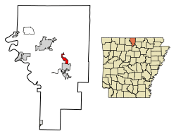 Location of Briarcliff in Baxter County, Arkansas. | |
| Coordinates: 36°16′17″N 92°16′50″W / 36.27139°N 92.28056°WCoordinates: 36°16′17″N 92°16′50″W / 36.27139°N 92.28056°W | |
| Country | United States |
| State | Arkansas |
| County | Baxter |
| Area[1] | |
| • Total | 2.22 sq mi (5.75 km2) |
| • Land | 2.22 sq mi (5.75 km2) |
| • Water | 0.00 sq mi (0.00 km2) |
| Elevation | 719 ft (219 m) |
| Population (2010) | |
| • Total | 236 |
| • Estimate (2017)[2] | 231 |
| • Density | 104.10/sq mi (40.20/km2) |
| Time zone | UTC-6 (Central (CST)) |
| • Summer (DST) | UTC-5 (CDT) |
| FIPS code | 05-08665 |
| GNIS feature ID | 0069346 |
Briarcliff is a second-class city in Baxter County, Arkansas, United States.[3] The population was 236 at the 2010 census.
History
The community began as a small retirement community near Lake Norfork following completion of the Norfork Dam. Initially an unincorporated area, residents voted to incorporate as a town in 1997. In 2000, town residents approved upgrading Briarcliff's status to a second-class city in order to establish a municipal government.[3]
Geography
Briarcliff is located at 36°16′17″N 92°16′50″W / 36.27139°N 92.28056°W (36.271281, -92.280624).[4]
According to the United States Census Bureau, the town has a total area of 4.7 km² (1.8 mi²), all land.
List Of highways
School District
Briarcliff is in the Norfork School District with students graduating from Norfork High School.[5]
Demographics
| Historical population | |||
|---|---|---|---|
| Census | Pop. | %± | |
| 2000 | 240 | — | |
| 2010 | 236 | −1.7% | |
| Est. 2017 | 231 | [2] | −2.1% |
| U.S. Decennial Census[6] 2014 Estimate[7] | |||
As of the census[8] of 2000, there were 240 people, 98 households, and 68 families residing in the town. The population density was 50.9/km² (131.8/mi²). There were 117 housing units at an average density of 24.8/km² (64.2/mi²). The racial makeup of the town was 97.92% White, 0.83% Native American, and 1.25% from two or more races.
There were 98 households out of which 32.7% had children under the age of 18 living with them, 56.1% were married couples living together, 10.2% had a female householder with no husband present, and 30.6% were non-families. 29.6% of all households were made up of individuals and 14.3% had someone living alone who was 65 years of age or older. The average household size was 2.45 and the average family size was 2.94.
In the town the population was spread out with 29.2% under the age of 18, 7.5% from 18 to 24, 22.1% from 25 to 44, 24.6% from 45 to 64, and 16.7% who were 65 years of age or older. The median age was 38 years. For every 100 females, there were 101.7 males. For every 100 females age 18 and over, there were 104.8 males.
The median income for a household in the town was $26,875, and the median income for a family was $32,188. Males had a median income of $26,000 versus $16,250 for females. The per capita income for the town was $16,420. About 9.0% of families and 13.7% of the population were below the poverty line, including 21.7% of those under the age of eighteen and 5.1% of those sixty five or over.
External links
- Map of Briarcliff (US Census Bureau)
- Map of Baxter County (US Census Bureau)
- Norfork School District
- Baxter County Historical and Genealogical Society
References
- ↑ "2017 U.S. Gazetteer Files". United States Census Bureau. Retrieved Aug 22, 2018.
- 1 2 "Population and Housing Unit Estimates". Retrieved March 24, 2018.
- 1 2 Teske, Steven (July 6, 2012). "Briarcliff (Baxter County)". Encyclopedia of Arkansas History and Culture. Butler Center for Arkansas Studies at the Central Arkansas Library System. Retrieved April 27, 2013.
- ↑ "US Gazetteer files: 2010, 2000, and 1990". United States Census Bureau. 2011-02-12. Retrieved 2011-04-23.
- ↑ School District Reference Map (2010 Census) Baxter County, AR (PDF) (Map). US Census Bureau. Retrieved 2011-07-12.
- ↑ "Census of Population and Housing". Census.gov. Archived from the original on May 12, 2015. Retrieved June 4, 2015.
- ↑ "Annual Estimates of the Resident Population for Incorporated Places: April 1, 2010 to July 1, 2014". Retrieved June 4, 2015.
- ↑ "American FactFinder". United States Census Bureau. Archived from the original on 2013-09-11. Retrieved 2008-01-31.
Municipalities and communities of Baxter County, Arkansas, United States | ||
|---|---|---|
| Cities | 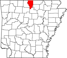 | |
| Towns | ||
| CDP | ||
| Unincorporated communities | ||
| Footnotes | ‡This populated place also has portions in an adjacent county or counties | |