Galivants Ferry Historic District
|
Galivants Ferry Historic District | |
 Galivants Ferry Baptist Church, June 2010 | |
  | |
| Location | Jct. of US 501, Pee Dee Rd., and Galivants Ferry Rd., Galivants Ferry, South Carolina |
|---|---|
| Coordinates | 34°3′0″N 79°14′42″W / 34.05000°N 79.24500°WCoordinates: 34°3′0″N 79°14′42″W / 34.05000°N 79.24500°W |
| Area | 750 acres (300 ha) |
| Architectural style | Late 19th And 20th Century Revivals |
| NRHP reference # | 01000321[1] |
| Added to NRHP | March 29, 2001 |
Galivants Ferry Historic District is a national historic district located at Galivants Ferry in Horry County, South Carolina.[2] It encompasses 28 contributing buildings that reflect the agricultural heritage of Galivants Ferry and of the larger Pee Dee region. Included are tenant farmer houses, storage barns, tobacco packhouses, curing barns, and sheds. The include the home of the Holliday family and a church that sits at the edge of a long stretch of tobacco fields on Pee Dee Road. Also included is a filling station (ca. 1922) along U.S. Route 501.[3]
It was listed on the National Register of Historic Places in 2001.[1]
Gallery
 John Monroe Johnson Holliday House
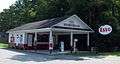 Filling Station
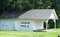 Grist Mill
 Barn
Barn
References
- 1 2 National Park Service (2009-03-13). "National Register Information System". National Register of Historic Places. National Park Service.
- ↑ Bartos, Ramona Murphy; Dale Jaeger (August 15, 2000). "Galivants Ferry Historic District" (pdf). National Register of Historic Places - Nomination and Inventory. Retrieved 21 July 2012.
- ↑ "South Carolina Department of Archives and History". National Register Properties in South Carolina:Galivants Ferry Historic District, Horry County (jct. of U.S. Hwy. 501, Pee Dee Rd., and Galivants Ferry Rd., Galivants Ferry), including 26 photos. South Carolina Department of Archives and History. 2010-06-21.
External links
- Galivants Ferry Historic District Map
- Galivants Ferry Historic District - Conway, South Carolina - U.S. National Register of Historic Places on Waymarking.com
| Topics |  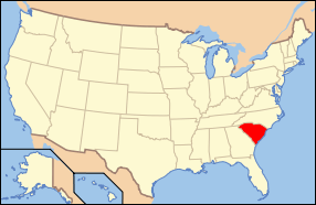 | |
|---|---|---|
| Lists by county |
| |
| Lists by city | ||
| Other lists | ||
This article is issued from
Wikipedia.
The text is licensed under Creative Commons - Attribution - Sharealike.
Additional terms may apply for the media files.