Lake Kawaguchi
| Lake Kawaguchi | |
|---|---|
 | |
| Location | Yamanashi Prefecture |
| Coordinates | 35°30′54″N 138°45′24″E / 35.51500°N 138.75667°ECoordinates: 35°30′54″N 138°45′24″E / 35.51500°N 138.75667°E |
| Primary inflows | none |
| Basin countries | Japan |
| Surface area | 6.13 km2 (2.37 sq mi) |
| Max. depth | 15.2 m (50 ft) |
| Shore length1 | 19.08 km (11.86 mi) |
| Surface elevation | 833 m (2,733 ft) |
| 1 Shore length is not a well-defined measure. | |

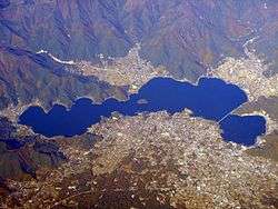
Lake Kawaguchi (河口湖 Kawaguchi-ko) is located in the border Fujikawaguchiko and Minobu, southern Yamanashi Prefecture near Mount Fuji, Japan. It is the second largest of the Fuji Five Lakes in terms of surface area, and is located at the lowest elevation. It is situated at an altitude of approximately 800 metres, which accounts for its relatively cool summers and frequently icy winters. It also has the longest shoreline of any of the Fuji Five Lakes.[1]
The lake is within the borders of the Fuji-Hakone-Izu National Park.[2]
The lake has no natural outlet, and flooding of settlements on its shores was a problem until the construction of a canal, completed in 1914, to connect it to a tributary of the Sagami River.
As with the other Fuji Five Lakes, the area is a popular resort, with many lakeside hotels, windsurfing facilities, camp sites, and excursion boats. Japanese crucian carp and wakasagi were introduced to the lake in the Meiji period, and sports fishing is also popular. Lake Kawaguchi is the most popular of the Fuji Five Lakes in terms of tourists, and has the most developed tourist infrastructure. The area also serves as a major hub for those wishing to climb Mount Fuji during the climbing season (July and August).
In 2013 the lake was added to the World Heritage List as part of the Fujisan Cultural Site.[3]
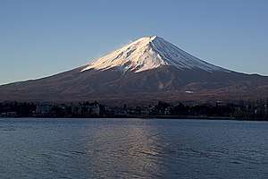 Mount Fuji and Lake Kawaguchi
 Mount Fuji and Kawaguchiko Station
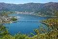 Eastern part
See also
External links
| Wikimedia Commons has media related to Lake Kawaguchi. |
Notes
- ↑ "Yamanashi Sightseeing Net". yamanashi-kankou.jp. Retrieved 2007-05-25.
- ↑ Fuji-Hakone-Izu National Park Archived 2012-08-28 at the Wayback Machine.(Ministry of the Environment (Japan))
- ↑ "Fujisan, sacred place and source of artistic inspiration: Maps". World Heritage. UNESCO. Retrieved 2013-07-04.