French Quarter
| French Quarter | |
| Vieux Carré | |
| New Orleans neighborhood | |
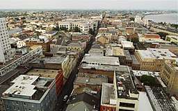 The French Quarter, looking north with Mississippi River to the right | |
| Country | United States |
|---|---|
| State | Louisiana |
| City | New Orleans |
| Planning District | District 1, French Quarter/CBD |
| Elevation | 3 ft (0.9 m) |
| Coordinates | 29°57′31″N 90°03′54″W / 29.95861°N 90.06500°WCoordinates: 29°57′31″N 90°03′54″W / 29.95861°N 90.06500°W |
| Area | 0.66 sq mi (1.7 km2) |
| - land | 0.49 sq mi (1 km2) |
| - water | 0.17 sq mi (0 km2), 25.76% |
| Population | 3,888 (2010) |
| Density | 7,935/sq mi (3,064/km2) |
| Mayor | LaToya Cantrell |
| Timezone | CST (UTC-6) |
| - summer (DST) | CDT (UTC-5) |
| ZIP Codes | 70116 - 70130 |
| Area code | 504 |
|
Vieux Carre Historic District | |
 French Quarter: Upper Chartres street looking towards Jackson Square and the spires of St. Louis Cathedral. | |
 | |
| Location | New Orleans, Louisiana |
|---|---|
| Built | 1734 |
| Architect | Multiple |
| NRHP reference # | 66000377 |
| Significant dates | |
| Added to NRHP | October 15, 1966[1] |
| Designated NHLD | December 21, 1965[2] |
The French Quarter, also known as the Vieux Carré ("Old Square") or Vieux Carré Historic District, is the oldest section of the City of New Orleans. Founded in 1718 by Jean-Baptiste Le Moyne de Bienville, New Orleans developed around the Vieux Carré, the city's central square. Today, the district is commonly known as the French Quarter, or simply "the Quarter," a reflection of the diminished French influence after the Louisiana Purchase.[3]
Most extant historical buildings were constructed in the late 1700s, during a period of Spanish rule, or during the early 1800s, after U.S. annexation and statehood. The district is a National Historic Landmark, and numerous contributing buildings have received separate designations of significance. The French Quarter is a prime destination for tourists and local residents.
Compared to other areas of the city, the Quarter experienced relatively light flood damage from Hurricane Katrina in 2005. The district was protected by its distance from breached levees and the strength and height of the nearest river levees and flood walls.[4]
Geography
The French Quarter is located at 29°57′31″N 90°03′54″W / 29.95861°N 90.06500°W[5] and has an elevation of 1 foot (0.3 m).[6] According to the United States Census Bureau, the district has a total area of 0.66 square miles (1.7 km2). 0.49 square miles (1.3 km2) of which is land and 0.17 square miles (0.4 km2) (25.76%) of which is water.
Boundaries
The most common definition of the French Quarter includes all the land stretching along the Mississippi River from Canal Street to Esplanade Avenue (13 blocks) and inland to North Rampart Street (seven to nine blocks). It equals an area of 78 square blocks. Some definitions, such as city zoning laws, exclude the properties facing Canal Street, which had already been redeveloped by the time architectural preservation was considered, and the section between Decatur Street and the river, much of which had long served industrial and warehousing functions.
Any alteration to structures in the remaining blocks is subject to review by the Vieux Carré Commission, which determines whether the proposal is appropriate for the historic character of the district. Its boundaries as defined by the City Planning Commission are: Esplanade Avenue to the north, the Mississippi River to the east, Canal Street, Decatur Street and Iberville Street to the south and the Basin Street, St. Louis Street and North Rampart Street to the west.[7]
The National Historic Landmark district is stated to be 85 square blocks.[2][8] The Quarter is subdistrict of the French Quarter/CBD Area.
Adjacent neighborhoods
- Faubourg Marigny (east)
- Mississippi River (south)
- Central Business District (west)
- Iberville (north)
- Tremé (north)
Demographics
As of the census of 2000, there were 4,176 people, 2,908 households, and 509 families residing in the neighborhood.[9] The population density was 8,523 /mi² (3,212 /km²).
As of the census of 2010, there were 3,813 people, 2,635 households, and 549 families residing in the neighborhood.[9]
18th and 19th centuries
Many of the buildings date from before 1803, when New Orleans was acquired by the United States in the Louisiana Purchase, although 19th-century and early 20th-century buildings were added to the area. Since the 1920s, the historic buildings have been protected by law and cannot be demolished; and any renovations or new construction in the neighborhood must be carried out in accordance with city regulations, preserving the historic architectural style.
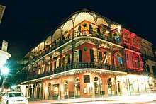
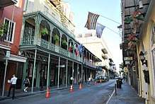
Most of the French Quarter's architecture was built during the late 18th century and the period of Spanish rule over the city, which is reflected in the architecture of the neighborhood. The Great New Orleans Fire (1788) and another great fire in 1794 destroyed most of the Quarter's old French colonial architecture, leaving the colony's new Spanish overlords to rebuild it according to more modern tastes. Their strict new fire codes mandated that all structures be physically adjacent and close to the curb to create a firewall. The old French peaked roofs were replaced with flat tiled ones, and wooden siding was banned in favor of fire-resistant stucco, painted in the pastel hues fashionable at the time. As a result, colorful walls and roofs and elaborately decorated ironwork balconies and galleries, from the late 18th and the early 19th centuries, abound. (In southeast Louisiana, a distinction is made between "balconies", which are self-supporting and attached to the side of the building, and "galleries," which are supported from the ground by poles or columns.)
When Anglophone Americans began to move in after the Louisiana Purchase, they mostly built on available land upriver, across modern-day Canal Street. This thoroughfare became the meeting place of two cultures, one Francophone Creole and the other Anglophone American. (Local landowners had retained architect and surveyor Barthelemy Lafon to subdivide their property to create an American suburb). The median of the wide boulevard became a place where the two contentious cultures could meet and do business in both French and English. As such, it became known as the "neutral ground", and this name is used for medians in the New Orleans area. Even before the Civil War, French Creoles had become a minority in the French Quarter.[10] In the late 19th century the Quarter became a less fashionable part of town, and many immigrants from southern Italy and Ireland settled there. (In 1905, the Italian consul estimated that one-third to one-half of the Quarter’s population were Italian-born or second generation Italian-Americans.)
20th century and beyond
In 1917, the closure of Storyville sent much of the vice formerly concentrated therein back into the French Quarter, which "for most of the remaining French Creole families ... was the last straw, and they began to move uptown."[11] This, combined with the loss of the French Opera House two years later, provided a bookend to the era of French Creole culture in the Quarter.[12] Many of the remaining French Creoles moved to the University area.[13]
In the early 20th century, the Quarter's cheap rents and air of decay attracted a bohemian artistic community, a trend which became pronounced in the 1920s. Many of these new inhabitants were active in the first preservation efforts in the Quarter, which began around that time.[14] As a result, the Vieux Carré Commission (VCC) was established in 1925. Although initially only an advisory body, a 1936 referendum to amend the Louisiana constitution afforded it a measure of regulatory power. It began to exercise more power in the 1940s to preserve and protect the district.[15]

Meanwhile, World War II brought thousands of servicemen and war workers to New Orleans as well as to the surrounding region's military bases and shipyards. Many of these sojourners paid visits to the Vieux Carré. Although nightlife and vice had already begun to coalesce on Bourbon Street in the two decades following the closure of Storyville, the war produced a larger, more permanent presence of exotic, risqué, and often raucous entertainment on what became the city's most famous strip. Years of repeated crackdowns on vice in Bourbon Street clubs, which took on new urgency under Mayor deLesseps Story Morrison, reached a crescendo with District Attorney Jim Garrison's raids in 1962, but Bourbon Street's clubs were soon back in business.[16]
The plan to construct an elevated Riverfront Expressway between the Mississippi River levee and the French Quarter consumed the attention of Vieux Carré preservationists through much of the 1960s. On December 21, 1965, the Vieux Carre Historic District was designated a National Historic Landmark.[2][8] After waging a decade-long battle against the Vieux Carré Riverfront Expressway that utilized the newly passed National Historic Preservation Act of 1966, preservationists and their allies forced the issue into federal court, eventually producing the cancellation of the freeway plan in 1969.[17]
The victory was important for the preservation of the French Quarter, but it was hardly the only challenge. Throughout the 1960s, new hotels opened regularly, often replacing large sections of the French Quarter. The VCC approved these structures as long as their designers adhered to prevailing exterior styles. Detractors, fearing that the Vieux Carré's charm might be compromised by the introduction of too many new inns, lobbied successfully for passage in 1969 of a municipal ordinance that forbade new hotels within the district's boundaries. However, the ordinance failed to stop the proliferation of timeshare condominiums and clandestine bed and breakfast inns throughout the French Quarter or high-rise hotels just outside its boundaries.[18] In the 1980s, many long-term residents were driven away by rising rents, as property values rose dramatically with expectations of windfalls from the planned 1984 World's Fair.
Effect of Hurricane Katrina
As with other parts of the city developed before the late 19th century, and on higher land predating New Orleans' levee systems, the French Quarter remained substantially dry following Hurricane Katrina. Its elevation is five feet (1.5 m) above sea level.[19] Some streets had minor flooding, and several buildings suffered significant wind damage. Most of the major landmarks suffered only minor damage.[20] In addition, the Quarter largely escaped the looting and violence that occurred after the storm; nearly all of the antique shops and art galleries in the French Quarter, for example, were untouched.[21]
Mayor Ray Nagin officially reopened the French Quarter on September 26, 2005 (almost a month after the storm), for business owners to inspect their property and clean up. Within a few weeks, a large selection of French Quarter businesses had reopened. The Historic New Orleans Collection's Williams Research Center Annex was the first new construction completed in the French Quarter after Hurricane Katrina.[22] In September 2015, SBP (a disaster relief organization that began after the hurricane), broke ground its new headquarters, moving from Chalmette to a 25,000-square-foot former salvage company on Toulouse Street as part of a $7.2 million relocation effort.[23] The organization moved into its new space in May 2016.[24] The building also serves as the national hub for the Disaster Resilience and Recovery Lab.[23]
Landmarks and attractions
Restaurants
- The neighborhood contains many restaurants, ranging from formal to casual, patronized by both visitors and locals. Some are well-known landmarks, such as Antoine's and Tujague's, which have been in business since the 19th century. Arnaud's, Galatoire's, Broussard's, and Brennan's are also venerable.
- Less historic—but also well-known—French Quarter restaurants include those run by chefs Paul Prudhomme ("K-Paul's"), Emeril Lagasse ("NOLA"), and John Besh. Port of Call on Esplanade Avenue has been in business for more than 30 years, and is recognized for its popular "Monsoon" drink (their answer to the "Hurricane" at Pat O'Brien's Bar) as well as for its food.
- The Gumbo Shop is another traditional eatery in the Quarter and where casual dress is acceptable. For a take-out lunch, Central Grocery on Decatur Street is the home of the original muffaletta Italian sandwich.
Hotels
- Accommodations in the French Quarter range from large international chain hotels, to bed and breakfasts, to time-share condominiums and small guest houses with only one or two rooms.
- The Audubon Cottages are a collection of seven luxuriously-appointed Creole cottages, two of which were utilized by John James Audubon in the early 19th century when he worked in New Orleans for a short time.
- The Hotel St. Pierre is a small hotel also consisting of historic French Quarter houses, with a courtyard patio.
- The French Quarter is well known for its traditional-style hotels, such as the Bourbon Orleans, Hotel Monteleone (family-owned), Royal Sonesta, the Astor, and the Omni Royal Orleans. These hotels offer prime locations, beautiful views, and/or historic atmosphere.
See also
- Buildings and architecture of New Orleans
- French Market
- French Quarter Festival, early April
- Jackson Square
- List of streets of New Orleans
- Louisiana Creole cuisine
- Satchmo SummerFest, early August
- List of National Historic Landmarks in Louisiana
- National Register of Historic Places listings in Orleans Parish, Louisiana
References
- ↑ National Park Service (2007-01-23). "National Register Information System". National Register of Historic Places. National Park Service.
- 1 2 3 "Vieux Carre Historic District". National Historic Landmark summary listing. National Park Service. Retrieved 2008-01-31.
- ↑ New Orleans French Quarter History, Architecture and Pictures
- ↑ "Archived copy". Archived from the original on 2015-01-30. Retrieved 2015-02-15.
- ↑ "US Gazetteer files: 2010, 2000, and 1990". United States Census Bureau. 2011-02-12. Retrieved 2011-04-23.
- ↑ "US Board on Geographic Names". United States Geological Survey. 2007-10-25. Retrieved 2008-01-31.
- ↑ Greater New Orleans Community Data Center. "French Quarter Neighborhood". Retrieved 2008-06-21.
- 1 2 Patricia Heintzelman (February 1975). "National Register of Historic Places Inventory-Nomination: Vieux Carré Historic District". National Park Service.
- 1 2 "French Quarter Neighborhood". Greater New Orleans Community Data Center. Retrieved 5 January 2012.
- ↑ Ellis, Scott S. (2010). Madame Vieux Carré: the French Quarter in the Twentieth Century. University of Mississippi. p. 7. ISBN 978-1-60473-358-7.
- ↑ Madame Vieux Carré, p. 20-21
- ↑ Madame Vieux Carré, p. 21
- ↑ New Orleans 1900 to 1920 by Mary Lou Widmer. Pelican Publishing: 2007. ISBN 1-58980-401-5 pg 23
- ↑ Madame Vieux Carré, p. 24
- ↑ Madame Vieux Carré, p. 43
- ↑ Souther, J. Mark. "New Orleans on Parade: Tourism and the Transformation of the Crescent City." Baton Rouge: Louisiana State University Press, 2013. pp. 41-50.
- ↑ Souther, "New Orleans on Parade," pp. 66-71
- ↑ Souther, "New Orleans on Parade," pp. 54-63, 203
- ↑ "Officials rescue Katrina's survivors amid 'chaos'". Archived from the original on September 11, 2005. Retrieved 2016-01-29. By Rick Wilking, Wed Aug 31, 2005, retrieved on 2009-11-27.
- ↑ FrenchQuarter.com: The Essential Guide to New Orleans' Oldest Neighborhood Archived 2005-11-04 at the Wayback Machine.
- ↑ Rosenblatt, Susannah; Rainey, James (September 27, 2005). "Katrina Takes a Toll on Truth, News Accuracy – Los Angeles Times". Los Angeles Times.
- ↑ THNOC - WRC Addition
- 1 2 Shannon, Robin (September 9, 2015). "Disaster recovery nonprofit plans new Mid-City headquarters". New Orleans CityBusiness (LA).
- ↑ Hodges, Quincy (May 19, 2016). "St. Bernard Project looks for tenants in new space". New Orleans CityBusiness (LA).
External links
| Wikimedia Commons has media related to French Quarter. |
| Wikivoyage has a travel guide for French Quarter. |
- Vieux Carré Commission at the Wayback Machine (archive index) (VCC) (Archive) - City of New Orleans
- Harriet Joor: The City of Iron Lace
- National Historic Landmarks Program: Vieux Carré Historic District
- Vieux Carré:A Creole Neighborhood in New Orleans, a National Park Service Teaching with Historic Places (TwHP) lesson plan
- A Travel Description: At Jackson Square in the French Quarter
| Topics | |
|---|---|
| Lists by states |
|
| Lists by insular areas | |
| Lists by associated states | |
| Other areas | |
| |
| Topics | ||
|---|---|---|
| Government | ||
| Colleges/Universities | ||
| Sports |
| |