Frankfort, Kansas
| Frankfort, Kansas | |
|---|---|
| City | |
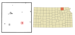 Location within Marshall County and Kansas | |
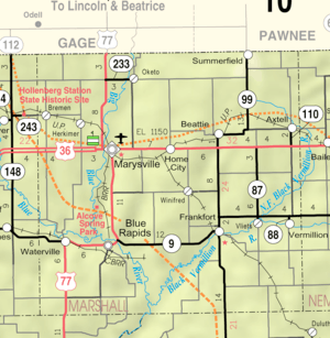 KDOT map of Marshall County (legend) | |
| Coordinates: 39°42′14″N 96°25′5″W / 39.70389°N 96.41806°WCoordinates: 39°42′14″N 96°25′5″W / 39.70389°N 96.41806°W | |
| Country | United States |
| State | Kansas |
| County | Marshall |
| Area[1] | |
| • Total | 1.02 sq mi (2.64 km2) |
| • Land | 1.01 sq mi (2.62 km2) |
| • Water | 0.01 sq mi (0.03 km2) |
| Elevation | 1,158 ft (353 m) |
| Population (2010)[2] | |
| • Total | 726 |
| • Estimate (2016)[3] | 692 |
| • Density | 710/sq mi (280/km2) |
| Time zone | UTC-6 (Central (CST)) |
| • Summer (DST) | UTC-5 (CDT) |
| ZIP code | 66427 |
| Area code | 785 |
| FIPS code | 20-24275 [4] |
| GNIS feature ID | 0473195 [5] |
| Website | CityOfFrankfort.org |
Frankfort is a city in Marshall County, Kansas, United States. As of the 2010 census, the city population was 726.[6] The town is famous for the 32 men it lost during World War II, more per capita than any other community in the USA.[7]
History
Frankfort was laid out in 1867 when the Central Branch Union Pacific Railroad was built through the area.[8] The nearby post office of Nottingham, established in 1857, moved roughly a half-mile northwest to meet the railroad. It was named for Frank Schmidt, a member of the town company.[9] Frankfort was incorporated as a city of the third class in 1875.[10]
Geography
Frankfort is located at 39°42′14″N 96°25′5″W / 39.70389°N 96.41806°W (39.703810, -96.417925).[11] According to the United States Census Bureau, the city has a total area of 1.02 square miles (2.64 km2), of which, 1.01 square miles (2.62 km2) is land and 0.01 square miles (0.03 km2) is water.[1]
Demographics
| Historical population | |||
|---|---|---|---|
| Census | Pop. | %± | |
| 1890 | 1,053 | — | |
| 1900 | 1,167 | 10.8% | |
| 1910 | 1,426 | 22.2% | |
| 1920 | 1,314 | −7.9% | |
| 1930 | 1,346 | 2.4% | |
| 1940 | 1,243 | −7.7% | |
| 1950 | 1,237 | −0.5% | |
| 1960 | 1,106 | −10.6% | |
| 1970 | 960 | −13.2% | |
| 1980 | 1,038 | 8.1% | |
| 1990 | 927 | −10.7% | |
| 2000 | 855 | −7.8% | |
| 2010 | 726 | −15.1% | |
| Est. 2016 | 692 | [3] | −4.7% |
| U.S. Decennial Census | |||
2010 census
As of the census[2] of 2010, there were 726 people, 307 households, and 195 families residing in the city. The population density was 718.8 inhabitants per square mile (277.5/km2). There were 363 housing units at an average density of 359.4 per square mile (138.8/km2). The racial makeup of the city was 98.8% White, 0.6% African American, 0.1% Asian, and 0.6% from two or more races. Hispanic or Latino of any race were 1.2% of the population.
There were 307 households of which 26.7% had children under the age of 18 living with them, 54.1% were married couples living together, 7.5% had a female householder with no husband present, 2.0% had a male householder with no wife present, and 36.5% were non-families. 33.2% of all households were made up of individuals and 20.8% had someone living alone who was 65 years of age or older. The average household size was 2.22 and the average family size was 2.80.
The median age in the city was 47.7 years. 21.5% of residents were under the age of 18; 5.4% were between the ages of 18 and 24; 21.3% were from 25 to 44; 23.3% were from 45 to 64; and 28.4% were 65 years of age or older. The gender makeup of the city was 48.9% male and 51.1% female.
2000 census
As of the census[4] of 2000, there were 855 people, 367 households, and 230 families residing in the city. The population density was 842.2 people per square mile (323.6/km²). There were 411 housing units at an average density of 404.8 per square mile (155.6/km²). The racial makeup of the city was 98.25% White, 0.35% African American, 0.12% Native American, 0.12% Pacific Islander, and 1.17% from two or more races. Hispanic or Latino of any race were 0.35% of the population.
There were 367 households out of which 24.8% had children under the age of 18 living with them, 55.0% were married couples living together, 4.4% had a female householder with no husband present, and 37.1% were non-families. 34.3% of all households were made up of individuals and 24.5% had someone living alone who was 65 years of age or older. The average household size was 2.19 and the average family size was 2.81.
In the city, the population was spread out with 20.2% under the age of 18, 8.0% from 18 to 24, 18.7% from 25 to 44, 19.5% from 45 to 64, and 33.6% who were 65 years of age or older. The median age was 46 years. For every 100 females, there were 88.3 males. For every 100 females age 18 and over, there were 85.8 males.
The median income for a household in the city was $28,269, and the median income for a family was $34,545. Males had a median income of $25,167 versus $19,375 for females. The per capita income for the city was $16,078. About 6.8% of families and 10.5% of the population were below the poverty line, including 11.3% of those under age 18 and 16.7% of those age 65 or over.
Education
Frankfort is a part of USD 380 Vermilion.[12]
The Frankfort Wildcats won the Kansas State High School boys basketball class 2A championship in 1973 and the class 1A DII championship in 2012.[13] Frankfort football teams have brought home state titles in 1983 in Class 1A, as well as 1996 in Class 2-1A. Both teams were coached by Larry Schroeder, a member of the KSHSAA Hall of Fame. Frankfort also won the 1A volleyball state championship in both 1986 and 2009.
References
- 1 2 "US Gazetteer files 2010". United States Census Bureau. Archived from the original on 2012-07-14. Retrieved 2012-07-06.
- 1 2 "American FactFinder". United States Census Bureau. Retrieved 2012-07-06.
- 1 2 "Population and Housing Unit Estimates". Retrieved June 9, 2017.
- 1 2 "American FactFinder". United States Census Bureau. Archived from the original on 2013-09-11. Retrieved 2008-01-31.
- ↑ "US Board on Geographic Names". United States Geological Survey. 2007-10-25. Retrieved 2008-01-31.
- ↑ "2010 City Population and Housing Occupancy Status". U.S. Census Bureau. Archived from the original on July 21, 2011. Retrieved July 17, 2011.
- ↑ Fry, Steve. "WWII's 'Frankfort boys' honored - CJOnline.com". cjonline.com. Archived from the original on 21 April 2017. Retrieved 4 May 2017.
- ↑ Blackmar, Frank Wilson (1912). Kansas: A Cyclopedia of State History, Embracing Events, Institutions, Industries, Counties, Cities, Towns, Prominent Persons, Etc. Standard Publishing Company. p. 679.
- ↑ Kansas State Historical Society (1916). Biennial Report of the Board of Directors of the Kansas State Historical Society. Kansas State Printing Plant. p. 236.
- ↑ Foster, Emma Elizabeth Calderhead (1917). History of Marshall County, Kansas: Its People, Industries, and Institutions. B.F. Bowen. p. 166.
- ↑ "US Gazetteer files: 2010, 2000, and 1990". United States Census Bureau. 2011-02-12. Retrieved 2011-04-23.
- ↑ "USD 380 Vermilion". USD 380. Retrieved 6 January 2017.
- ↑ "Basketball". KSHSAA. Retrieved 3 January 2017.
External links
| Wikimedia Commons has media related to Frankfort, Kansas. |
- City
- City of Frankfort
- Frankfort - Directory of Public Officials
- Frankfort - Information, TheTaleOfTheTrail.org
- Schools
- USD 380, local school district
- Maps
- Frankfort City Map, KDOT
Municipalities and communities of Marshall County, Kansas, United States | ||
|---|---|---|
| Cities |  | |
| CDP | ||
| Unincorporated communities | ||
| Ghost towns | ||
| Townships | ||