Bremen, Kansas
| Bremen, Kansas | |
|---|---|
| Unincorporated community | |
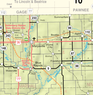 KDOT map of Marshall County (legend) | |
| Coordinates: 39°54′05″N 96°47′21″W / 39.90139°N 96.78917°WCoordinates: 39°54′05″N 96°47′21″W / 39.90139°N 96.78917°W[1] | |
| Country | United States |
| State | Kansas |
| County | Marshall |
| Founded | 1886 |
| Elevation[1] | 1,332 ft (406 m) |
| Time zone | UTC-6 (CST) |
| • Summer (DST) | UTC-5 (CDT) |
| ZIP code | 66412 [2] |
| Area code | 785 |
| FIPS code | 20-08300 [1] |
| GNIS feature ID | 472665 [1] |


Bremen is an unincorporated community in Marshall County, Kansas, United States.[1]
History
Bremen was laid out in 1886 by Henry Brenneke, a native of Bremen, Germany.[3]
Geography
Bremen is located at 39°54′5″N 96°47′21″W / 39.90139°N 96.78917°W (39.9013918, -96.7891906).[1] It is 5 miles (8.0 km) east of Hanover and 4 miles (6.4 km) north of U.S. Route 36.
Economy
Bremen Farmers Mutal Insurance Company is the main employer in Bremen. Also, the community has a U.S. Post Office.
References
- 1 2 3 4 5 6 Geographic Names Information System (GNIS) details for Bremen, Kansas; United States Geological Survey (USGS); October 13, 1978.
- ↑ United States Postal Service (2012). "USPS - Look Up a ZIP Code". Retrieved 2012-02-15.
- ↑ Foster, Emma Elizabeth Calderhead (1917). History of Marshall County, Kansas: Its People, Industries, and Institutions. B.F. Bowen. p. 163.
External links
Municipalities and communities of Marshall County, Kansas, United States | ||
|---|---|---|
| Cities | 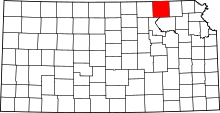 | |
| CDP | ||
| Unincorporated communities | ||
| Ghost towns | ||
| Townships | ||
This article is issued from
Wikipedia.
The text is licensed under Creative Commons - Attribution - Sharealike.
Additional terms may apply for the media files.