Fort Barton Site
|
Fort Barton Site | |
 | |
| Location |
Lawton and Highland Aves. Tiverton, Rhode Island |
|---|---|
| Coordinates | 41°37′31″N 71°12′25″W / 41.6253°N 71.2070°WCoordinates: 41°37′31″N 71°12′25″W / 41.6253°N 71.2070°W |
| NRHP reference # | 73000056[1] |
| Added to NRHP | March 7, 1973 |
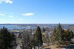
The Fort Barton Site is the site of an historic American Revolutionary War fort, now located in a public park at Lawton and Highland Avenues in Tiverton, Rhode Island. All that remains of the fort are its earthworks, a roughly oblong structure about 150 feet (46 m) long and 100 feet (30 m) deep. The site was a defensive post overlooking the main ferry crossing between Tiverton and Aquidneck Island, which was under British control at the time of its construction in 1777. The ferry was used as a launching position for American forces during the Battle of Rhode Island in August 1778. The site was named after Lt. Col. William Barton who successfully captured the British General Prescott during a midnight raid on the British headquarters at Prescott Farm in what is now Portsmouth.[2]
Fort Barton was added to the National Register of Historic Places in 1973.[1]
See also
References
- 1 2 National Park Service (2009-03-13). "National Register Information System". National Register of Historic Places. National Park Service.
- ↑ "NRHP nomination for Fort Barton Site" (PDF). Rhode Island Preservation. Retrieved 2014-09-25.
External links
- Field, Edward. Revolutionary defences in Rhode Island: an historical account of the fortifications and beacons erected during the American revolution, with muster rolls of the companies stationed along the shores of Narragansett bay. Preston and Rounds. Retrieved 9 April 2016.
- Fort History information
| Topics | |
|---|---|
| Lists by states |
|
| Lists by insular areas | |
| Lists by associated states | |
| Other areas | |
| |