List of fjords in Canada

Location of Howe Sound in British Columbia.

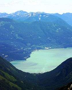
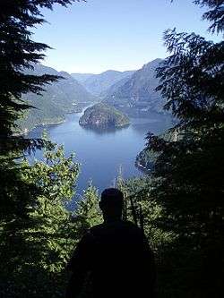
Fjords in Canada are long, narrow inlets characterized by steep sides, created in a valley carved by glacial activity. A fjord can have two or more basins separated by sills. The bowls can have a depth of 20 to 500 m (66 to 1,640 ft) and the dividing sills can raise up to a few metres below the water surface. Mountainous glaciated areas in Canada are along the British Columbia Coast: from the Alaskan border along the Portland Canal to Indian Arm. Kingcome Inlet is a typical West Coast fjord.

Saglek Fjord,[1] Nachvak Fjord,[1] Anaktalâk Bay,[1] Western Brook Pond, Hebron Fjord, Bonne Bay and Trout River Pond in Gros Morne National Park are located along the coastline of Newfoundland and Labrador.[2]

Quebec's Saguenay River valley contains a fjord. The Saguenay Fjord is 100 km (62 mi) long and 275 m (902 ft) deep.[2]

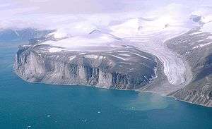
The Canadian Arctic Archipelago features fjords such as those around Ellesmere and Baffin Island, including Alexandra Fjord, Ellesmere Island,[3] and Sam Ford Fiord,[4] Baffin Island.

When a portion of the high cliff wall falls off, it may cause a tsunami. This occurred in the early 20th century at Western Brook Pond of Gros Morne National Park when a 30 m (98 ft) tsunami was created after Broke Off Cliff fell.[5]

Fjords listed here may consist of several complex waterways. These waterways may contribute to the length of the fjord. For more information on these please see the main fjord source or Wikipedia article. Some examples are Dean Channel and Douglas Channel. The locality of Hagensborg in the Bella Coola Valley in the Dean Channel fjord was settled by Norwegian immigrants in 1894 as it reminded them of home.[6] The total length of the fjord from the head of Dean Channel to the mouth of Fitz Hugh Sound is about 170 km (110 mi) rivalling Hardangerfjord in Norway for length. The Hardangerfjord, the Queen of fjords, at a length of 179 km (111 mi) is claimed to be fourth largest fjord in the world and second largest of Norway.[7][8]

Anaktalak Fjord, Saglek Fjord and Nachvak Fjord off the coast of Newfoundland and Labrador are being studied for environmental changes due to global warming. Increased tourism and marine traffic, contaminants from air, water or industrial pollution, changing weather patterns are affecting what once had been pristine water basins of the fjords protected by sills.[1]

The use of the word canal to name fjords or inlets on the British Columbian and Southeast Alaskan coast is a legacy of the Spanish exploration of the area in the 18th century. For example, Haro Strait between Victoria and the San Juan Islands was originally Canal de Haro. The English cognate to the Spanish canal is "channel", which is found throughout the coast, cf. Dean Channel.

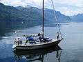
Some fjords on the British Columbian coast have rapids, termed skookumchucks which means strong waters in Chinook Jargon). Skookumchucks are caused by the shallows and narrows near the mouth of a fjord as the water inside the fjord's depths is drawn through, to or from, the more open waters beyond.[9][10][11]

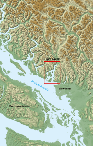
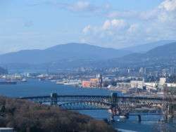
The phenomenon of Mountain-gap wind or squamish or outflow affects the fjords of Canada and Norway. The outflow winds at the Salt and Bols fjords of Norway and the Howe Sound and Portland Inlet of Canada have been compared. European winds may be termed Bora. The cold dry air of the continental interior seeks out the easier passage through the fjord valley creating hurricane-force winds.[12]

Western Brook Pond, fjord or fjord lake

According to the definition, fjord, Western Brook Pond and Trout River Pond in Newfoundland's Gros Morne National Park, are also often described as a fjords, but are actually freshwater lakes cut off from the sea, so is not a fjord in the English sense of the term. Such lakes are sometimes called "fjord lakes".[13] It is of interest to note that Pissing Mare Falls at 350 m (1,150 ft) high, is one of several waterfalls to drain into Western Brook Pond, Along the British Columbia Coast, a notable fjord-lake is Owikeno Lake, which is a freshwater extension of Rivers Inlet.

List of fjords

List of Canadian fjords:
Image Fjords Province Co-ordinates Comments
Agate Fiord[14]Nunavut79°26′59″N 093°00′00″W / 79.44972°N 93.00000°W / 79.44972; -93.00000 (Agate Fiord)
Akpait Fiord[14]Nunavut66°53′18″N 061°53′34″W / 66.88833°N 61.89278°W / 66.88833; -61.89278 (Akpait Fiord)
Aktijartukan Fiord[14]Nunavut65°06′00″N 063°55′00″W / 65.10000°N 63.91667°W / 65.10000; -63.91667 (Aktijartukan Fiord)
Alan Reach[15]British Columbia
Alberni Inlet[16]British Columbia49°05′00″N 124°49′00″W / 49.08333°N 124.81667°W / 49.08333; -124.81667 (Alberni Inlet)Length 40 km (25 mi)
Alexandra Fiord[14]Nunavut78°54′00″N 075°59′59″W / 78.90000°N 75.99972°W / 78.90000; -75.99972 (Alexandra Fjord)
Alluviaq Fiord[14]Nunavut59°29′44″N 065°09′05″W / 59.49556°N 65.15139°W / 59.49556; -65.15139 (Alluviaq Fiord, Nunavut)
Alluviaq Fjord[17]Quebec59°27′00″N 065°10′00″W / 59.45000°N 65.16667°W / 59.45000; -65.16667 (Alluviaq Fjord, Quebec)
Anaktalâk Bay[1]Newfoundland and Labrador
Archer Fiord[14]Nunavut81°25′00″N 067°00′00″W / 81.41667°N 67.00000°W / 81.41667; -67.00000 (Archer Fiord)
Arthur Fiord[14]Nunavut76°30′00″N 093°24′00″W / 76.50000°N 93.40000°W / 76.50000; -93.40000 (Arthur Fiord)
Aurland Fiord[14]Nunavut81°04′00″N 094°25′00″W / 81.06667°N 94.41667°W / 81.06667; -94.41667 (Aurland Fiord)
Ayles Fiord[14]Nunavut82°44′59″N 080°00′00″W / 82.74972°N 80.00000°W / 82.74972; -80.00000 (Ayles Fiord)
Ayr Lake[14]Nunavut70°24′00″N 070°15′00″W / 70.40000°N 70.25000°W / 70.40000; -70.25000 (Ayr Fiord)Structurally a fjord, part of Baffin Island's northeastern coast fjord system
Baad Fiord, Boat Fiord[14]Nunavut76°28′00″N 086°30′00″W / 76.46667°N 86.50000°W / 76.46667; -86.50000 (Baad Fiord)
Bals Fiord, Boat Fiord[14]Nunavut80°24′00″N 095°45′00″W / 80.40000°N 95.75000°W / 80.40000; -95.75000 (Bals Fiord)
Barrie Reach[15][18]British Columbia53°28′00″N 128°16′00″W / 53.46667°N 128.26667°W / 53.46667; -128.26667 (Barrie Reach)
Baumann Fiord[14]Nunavut77°40′00″N 085°34′59″W / 77.66667°N 85.58306°W / 77.66667; -85.58306 (Baumann Fiord)
Bay Fiord[14]Nunavut78°55′00″N 083°30′00″W / 78.91667°N 83.50000°W / 78.91667; -83.50000 (Bay Fiord)
Beitstad Fiord[14]Nunavut79°04′00″N 078°10′00″W / 79.06667°N 78.16667°W / 79.06667; -78.16667 (Beitstad Fiord)
Belize Inlet[15][19][20]British Columbia51°08′00″N 127°09′00″W / 51.13333°N 127.15000°W / 51.13333; -127.15000 (Belize Inlet)A part of the fjord network Seymour-Belize Inlet Complex (SBIC), located on the north coast of British Columbia. Belize Inlet, which is 50 km (31 mi) in length has its own side inlets, narrow waterways named Wentworth Sound and Alison Sound.
Bentham Fiord[14]Nunavut77°07′59″N 080°12′00″W / 77.13306°N 80.20000°W / 77.13306; -80.20000 (Bentham Fiord)
Bentinck Arm[15][21]British ColumbiaSee also Dean Channel Bentinck Arm is a deep fjord which runs about 15 km (9.3 mi) in length and is about 2.3 km (1.4 mi) in width. The fjord has a depth between 200 to 400 m (660 to 1,310 ft).
Bird Fiord[14]Nunavut77°10′00″N 086°59′59″W / 77.16667°N 86.99972°W / 77.16667; -86.99972 (Bird Fiord)
Blind Fiord[14]Nunavut78°13′59″N 086°16′00″W / 78.23306°N 86.26667°W / 78.23306; -86.26667 (Blind Fiord)
Blue Fiord, Blaa Fiord[14]Nunavut77°16′00″N 087°04′59″W / 77.26667°N 87.08306°W / 77.26667; -87.08306 (Blue Fiord)
Boas Fiord[14]Nunavut66°48′00″N 062°49′00″W / 66.80000°N 62.81667°W / 66.80000; -62.81667 (Boas Fiord)
Bonne Bay[22][23]Newfoundland and Labrador49°29′02″N 057°59′06″W / 49.48389°N 57.98500°W / 49.48389; -57.98500 (Bonne Bay)There is both Inner Bonne Bay and outer Bonne Bay. Outer Bonne Bay opens up to the entrance of the fjord of Bonne Bay.
Borup Fiord[14]Nunavut80°37′00″N 083°25′00″W / 80.61667°N 83.41667°W / 80.61667; -83.41667 (Borup Fiord)
Briggs InletBritish Columbia52°22′00″N 128°00′00″W / 52.36667°N 128.00000°W / 52.36667; -128.00000 (Briggs Inlet)
Bukken Fiord[14]Nunavut80°43′00″N 094°55′00″W / 80.71667°N 94.91667°W / 80.71667; -94.91667 (Bukken Fiord)
Bunde Fiord[14]Nunavut80°36′00″N 094°55′00″W / 80.60000°N 94.91667°W / 80.60000; -94.91667 (Bunde Fiord)
Burke Channel[24][25]British Columbia51°55′00″N 127°53′00″W / 51.91667°N 127.88333°W / 51.91667; -127.88333 (Burke Channel)see also the Major inlets of British Columbia coast, and Dean Channel.

The fjord region of western mainland British Columbia,... Douglas Channel in the north to Burke Channel and Dean Channel in the south

BATHOLITHS[25]
Burrard Inlet[26]British Columbia49°18′15″N 123°12′56″W / 49.30417°N 123.21556°W / 49.30417; -123.21556 (Burrard Inlet)Burrard Inlet is a relatively shallow-sided coastal fjord in southwestern British Columbia.
Bute Inlet[27]British Columbia50°35′00″N 124°55′00″W / 50.58333°N 124.91667°W / 50.58333; -124.91667 (Bute Inlet)
Cambridge Fiord, Glen Roy Fiord[14]Nunavut71°25′59″N 074°45′00″W / 71.43306°N 74.75000°W / 71.43306; -74.75000 (Cambridge Fiord)
Cañon Fiord, Canon Fiord, Canyon Fiord[14]Nunavut80°00′00″N 082°34′59″W / 80.00000°N 82.58306°W / 80.00000; -82.58306 (Cañon Fiord)
Chandler Fiord[14]Nunavut81°37′59″N 068°46′00″W / 81.63306°N 68.76667°W / 81.63306; -68.76667 (Chandler Fiord)
Chief Matthews Bay[15]British Columbiasee also the Major inlets of British Columbia coast.
Clark Fiord[14]Nunavut70°58′00″N 072°07′00″W / 70.96667°N 72.11667°W / 70.96667; -72.11667 (Clark Fiord)
Clearwater Fiord, Issortukdjuak Fiord, Kingua Fiord[14]Nunavut66°34′00″N 067°27′00″W / 66.56667°N 67.45000°W / 66.56667; -67.45000 (Clearwater Fiord)
Clyde InletNunavut70°19′00″N 068°19′00″W / 70.31667°N 68.31667°W / 70.31667; -68.31667 (Clyde Inlet)
Confederation Fiord[14]Nunavut68°10′00″N 067°19′00″W / 68.16667°N 67.31667°W / 68.16667; -67.31667 (Confederation Fiord)
Conybeare Fiord, Chandler Fiord, Conybeare Bay[14]Nunavut81°34′00″N 067°34′59″W / 81.56667°N 67.58306°W / 81.56667; -67.58306 (Conybeare Fiord)
Coronation Fiord[14]Nunavut67°13′59″N 064°34′59″W / 67.23306°N 64.58306°W / 67.23306; -64.58306 (Coronation Fiord)
d'Iberville Fiord[14]Nunavut80°34′00″N 078°59′59″W / 80.56667°N 78.99972°W / 80.56667; -78.99972 (d'Iberville Fiord)
Dean Channel[28]British Columbia52°19′00″N 127°31′00″W / 52.31667°N 127.51667°W / 52.31667; -127.51667 (Dean Channel)The total length of the fjord from the head of Dean Channel to the mouth of Fitz Hugh Sound is about 170 km (110 mi) rivalling Hardangerfjord in Norway for length.
Denmark Fiord[14]Nunavut70°34′59″N 103°04′59″W / 70.58306°N 103.08306°W / 70.58306; -103.08306 (Denmark Fiord)
Desolation Sound[29]British Columbia50°07′00″N 124°47′00″W / 50.11667°N 124.78333°W / 50.11667; -124.78333 (Desolation Sound)see also the Major inlets of British Columbia coast, and Desolation Sound Marine Park and Recreation Park.
Devastation Channel[15][30][31]British Columbia53°40′00″N 128°50′00″W / 53.66667°N 128.83333°W / 53.66667; -128.83333 (Devastation Channel)
Dexterity Fiord[14]Nunavut71°14′59″N 073°01′59″W / 71.24972°N 73.03306°W / 71.24972; -73.03306 (Dexterity Fiord)
Disraeli Fiord[14]Nunavut82°49′00″N 073°20′59″W / 82.81667°N 73.34972°W / 82.81667; -73.34972 (Disraeli Fiord)
Douglas Channel[32]British Columbia53°40′00″N 129°08′00″W / 53.66667°N 129.13333°W / 53.66667; -129.13333 (Douglas Channel)Length 90 km (56 mi)
East Fiord[14]Nunavut79°23′59″N 093°19′59″W / 79.39972°N 93.33306°W / 79.39972; -93.33306 (East Fiord)
Eglinton Fiord, Gifford Inlet, Gifford River[14]Nunavut70°40′00″N 070°03′00″W / 70.66667°N 70.05000°W / 70.66667; -70.05000 (Eglinton Fiord)
Eids Fiord[14]Nunavut77°21′10″N 087°06′00″W / 77.35278°N 87.10000°W / 77.35278; -87.10000 (Eids Fiord)
Ekalugad Fiord[14]Nunavut68°46′00″N 068°37′00″W / 68.76667°N 68.61667°W / 68.76667; -68.61667 (Ekalugad Fiord)
Ekortiarsuk Fiord[33]Newfoundland and Labrador59°59′32″N 064°22′22″W / 59.99222°N 64.37278°W / 59.99222; -64.37278 (Ekortiarsuk Fiord)
Emma Fiord[14]Nunavut81°28′59″N 088°59′59″W / 81.48306°N 88.99972°W / 81.48306; -88.99972 (Emma Fiord)
Europa Reach[15][34]British Columbia53°26′59″N 128°24′00″W / 53.44972°N 128.40000°W / 53.44972; -128.40000 (Europa Reach)See also List of rivers of British Columbia and British Columbia Coast
Exaluin Fiord[14]Nunavut65°40′00″N 062°54′00″W / 65.66667°N 62.90000°W / 65.66667; -62.90000 (Exaluin Fiord)
Expedition Fiord[14]Nunavut79°19′59″N 091°59′59″W / 79.33306°N 91.99972°W / 79.33306; -91.99972 (Expedition Fiord)
Fabricius Fiord[14]Nunavut72°22′00″N 084°37′59″W / 72.36667°N 84.63306°W / 72.36667; -84.63306 (Fabricius Fiord)
Fisher Channel[15][35][36]British Columbia52°08′00″N 127°53′00″W / 52.13333°N 127.88333°W / 52.13333; -127.88333 (Fisher Channel)Fisher Channel leads into Dean Channel, and towards Ocean Falls.
Fitz Hugh Sound[37]British Columbia51°45′00″N 127°55′12″W / 51.75000°N 127.92000°W / 51.75000; -127.92000 (Fitz Hugh Sound)See also Dean Channel
Fjord de Salluit[17]Quebec62°12′45″N 075°41′41″W / 62.21250°N 75.69472°W / 62.21250; -75.69472 (Fjord de Salluit)
Fjord du Saguenay[17]Quebec48°07′54″N 069°43′34″W / 48.13167°N 69.72611°W / 48.13167; -69.72611 (Fjord du Saguenay)
Foss Fiord[14]Nunavut70°22′00″N 086°59′59″W / 70.36667°N 86.99972°W / 70.36667; -86.99972 (Foss Fiord)
Fram Fiord[14]Nunavut76°31′00″N 081°19′00″W / 76.51667°N 81.31667°W / 76.51667; -81.31667 (Fram Fiord)
Frederick Sound[15][38]British Columbia51°01′00″N 126°43′00″W / 51.01667°N 126.71667°W / 51.01667; -126.71667 (Frederick Sound)Also called Prince Frederick Sound or Prince Frederick's Sound. Seymour Inlet has its own side-inlets, the largest being a south arm named Frederick Sound, with a side-inlet of its own named Salmon Arm.
Gardner Canal[39]British Columbia53°34′59″N 128°46′01″W / 53.58306°N 128.76694°W / 53.58306; -128.76694 (Gardner Canal)Technically a side-inlet of the larger Douglas Channel. The Gardner is principal inlet/fjord of a length 90 km (56 mi).
Gibbs Fiord[14]Nunavut70°49′14″N 071°54′50″W / 70.82056°N 71.91389°W / 70.82056; -71.91389 (Gibbs Fiord)
Gibs Fiord[14]Nunavut79°52′59″N 087°14′59″W / 79.88306°N 87.24972°W / 79.88306; -87.24972 (Gibs Fiord)
Gifford Fiord, Gifford Inlet, Gifford River[14]Nunavut70°10′00″N 082°29′59″W / 70.16667°N 82.49972°W / 70.16667; -82.49972 (Gifford Fiord)
Glacier Fiord[14]Nunavut78°22′00″N 089°28′59″W / 78.36667°N 89.48306°W / 78.36667; -89.48306 (Glacier Fiord)
Goose Fiord, Gifford Inlet, Gifford River[14]Nunavut76°35′59″N 088°34′59″W / 76.59972°N 88.58306°W / 76.59972; -88.58306 (Goose Fiord)
Greely Fiord, Gifford Inlet, Gifford River[14]Nunavut80°29′59″N 081°40′00″W / 80.49972°N 81.66667°W / 80.49972; -81.66667 (Greely Fiord)
Grise Fiord[14]Nunavut76°34′59″N 083°13′59″W / 76.58306°N 83.23306°W / 76.58306; -83.23306 (Grise Fiord)There is a hamlet of the same name, Grise Fiord on this fiord. Grise Fiord means "pig fiord" and in the native terminology is Grise Fiord is named Ausuittuq.
Haakon Fiord[14]Nunavut78°49′59″N 100°45′00″W / 78.83306°N 100.75000°W / 78.83306; -100.75000 (Haakon Fiord)
Harbour Fiord[14]Nunavut76°31′00″N 084°07′59″W / 76.51667°N 84.13306°W / 76.51667; -84.13306 (Harbour Fiord)
Hare Fiord[14]Nunavut81°01′00″N 085°29′59″W / 81.01667°N 85.49972°W / 81.01667; -85.49972 (Hare Fiord)
Hayes Fiord[14]Nunavut79°01′59″N 076°45′00″W / 79.03306°N 76.75000°W / 79.03306; -76.75000 (Hayes Fiord)
Hebron Fjord[33]Newfoundland and Labrador58°8′49″N 062°52′50″W / 58.14694°N 62.88056°W / 58.14694; -62.88056 (Hebron Fjord)See also Torngat Mountains
Hotham SoundBritish Columbiasee also the Major inlets of British Columbia coast, Nelson Island (British Columbia) and St. Vincent Bay, British Columbia
Howe Sound[40]British Columbia49°33′00″N 123°16′00″W / 49.55000°N 123.26667°W / 49.55000; -123.26667 (Howe Sound)
Ijellirtung Fiord[41]Nunavut69°19′59″N 068°40′01″W / 69.33306°N 68.66694°W / 69.33306; -68.66694 (Ijellirtung Fiord)
Ikkudliayuk Fiord[33]Newfoundland and Labrador60°04′17″N 064°29′58″W / 60.07139°N 64.49944°W / 60.07139; -64.49944 (Ikkudliayuk Fiord)
Indian Arm[42]British Columbia49°22′00″N 122°53′00″W / 49.36667°N 122.88333°W / 49.36667; -122.88333 (Indian Arm)Indian Arm Provincial Park protects the area of Indian Arm fjord
Ingnit Fiord, Ingnitelling[14]Nunavut65°47′59″N 062°40′00″W / 65.79972°N 62.66667°W / 65.79972; -62.66667 (Ingnit Fiord)
Inugsuin Fiord[14]Nunavut69°53′39″N 069°14′59″W / 69.89417°N 69.24972°W / 69.89417; -69.24972 (Inugsuin Fiord)
Iqalualuit Fiord[14]Nunavut68°34′59″N 068°34′59″W / 68.58306°N 68.58306°W / 68.58306; -68.58306 (Iqalualuit Fiord)
Iqalujjuaq Fiord[14]Nunavut65°40′00″N 065°04′59″W / 65.66667°N 65.08306°W / 65.66667; -65.08306 (Iqalujjuaq Fiord)
Isortoq Fiord[14]Nunavut69°55′00″N 077°04′59″W / 69.91667°N 77.08306°W / 69.91667; -77.08306 (Isortoq Fiord)
Iterungnek Fiord[33]Newfoundland and Labrador58°15′17″N 062°48′30″W / 58.25472°N 62.80833°W / 58.25472; -62.80833 (Iterungnek Fiord)
Itirbilung Fiord[14]Nunavut69°17′59″N 068°40′00″W / 69.29972°N 68.66667°W / 69.29972; -68.66667 (Itirbilung Fiord)
Jervis Inlet[43]British Columbia49°59′48″N 123°58′07″W / 49.99667°N 123.96861°W / 49.99667; -123.96861 (Jervis Inlet)Jervis Inlet is 90 km (56 mi) in length. Between Toba Inlet and Jervis Inlet to its west, however, there is a freshwater fjord, Powell Lake
Jokel Fiord[14]Nunavut78°52′00″N 078°04′59″W / 78.86667°N 78.08306°W / 78.86667; -78.08306 (Jokel Fiord)
Jugeborg Fiord[14]Nunavut81°14′09″N 089°30′00″W / 81.23583°N 89.50000°W / 81.23583; -89.50000 (Jugeborg Fiord)
Kairolik Fiord[14]Nunavut65°31′00″N 063°31′00″W / 65.51667°N 63.51667°W / 65.51667; -63.51667 (Kairolik Fiord)
Kangalaksiorvik Fiord[33]Newfoundland and Labrador59°24′04″N 063°56′26″W / 59.40111°N 63.94056°W / 59.40111; -63.94056 (Kangalaksiorvik Fiord)
Kangerk Fiord[14]Nunavut66°22′59″N 067°17′59″W / 66.38306°N 67.29972°W / 66.38306; -67.29972 (Kangerk Fiord)
Kangert Fiord, Kangertloaping Fiord[14]Nunavut67°05′30″N 063°31′30″W / 67.09167°N 63.52500°W / 67.09167; -63.52500 (Kangert Fiord)
Kangilo Fiord, Kaggilartung Fiord[14]Nunavut66°17′59″N 067°35′59″W / 66.29972°N 67.59972°W / 66.29972; -67.59972 (Kangilo Fiord)
Kangirlugag Fiord[14]Nunavut68°47′59″N 068°10′00″W / 68.79972°N 68.16667°W / 68.79972; -68.16667 (Kangirlugag Fiord)
Kangirtukutaaruluq Fiord[14]Nunavut67°41′39″N 064°29′09″W / 67.69417°N 64.48583°W / 67.69417; -64.48583 (Kangirtukutaaruluq Fiord)
Kangok Fiord[14]Nunavut68°37′00″N 068°25′00″W / 68.61667°N 68.41667°W / 68.61667; -68.41667 (Kangok Fiord)
Khutzeymateen Inlet[15]British Columbia54°42′59″N 130°12′31″W / 54.71639°N 130.20861°W / 54.71639; -130.20861 (Khutzeymateen Inlet)
Kiltuish Inlet[15][44]British Columbia53°22′00″N 128°29′00″W / 53.36667°N 128.48333°W / 53.36667; -128.48333 (Kiltuish Inlet)
Kingcome InletBritish Columbia50°55′00″N 126°30′00″W / 50.91667°N 126.50000°W / 50.91667; -126.50000 (Kingcome Inlet)A lesser principal fjords of the British Columbia Coast.
Kingnait Fiord[14]Nunavut66°02′44″N 064°57′29″W / 66.04556°N 64.95806°W / 66.04556; -64.95806 (Kingnait Fiord)
Kingnelling Fiord[14]Nunavut67°27′10″N 064°15′20″W / 67.45278°N 64.25556°W / 67.45278; -64.25556 (Kingnelling Fiord)
Kitimat Arm[15][15][45]British Columbia54°55′00″N 128°42′00″W / 54.91667°N 128.70000°W / 54.91667; -128.70000 (Kitimat Arm)See also Douglas Channel and Kitimat River
Knight Inlet[46]British Columbia50°45′00″N 125°40′00″W / 50.75000°N 125.66667°W / 50.75000; -125.66667 (Knight Inlet)Knight Inlet is one of the longest great saltwater inlets/fjords on the BC Coast at c. 125 km (78 mi) in length; it is about 2.5 km (1.6 mi) in average width.
Komaktorvik Fiord[33]Newfoundland and Labrador59°17′00″N 063°43′56″W / 59.28333°N 63.73222°W / 59.28333; -63.73222 (Komaktorvik Fiord)
Kulutingwak Fiord[14]Nunavut82°07′00″N 082°48′00″W / 82.11667°N 82.80000°W / 82.11667; -82.80000 (Kulutingwak Fiord)
Kumlien Fiord[14]Nunavut65°23′59″N 064°44′59″W / 65.39972°N 64.74972°W / 65.39972; -64.74972 (Kumlien Fiord)
Kwatna Inlet[15][47]British Columbia52°06′00″N 127°30′00″W / 52.10000°N 127.50000°W / 52.10000; -127.50000 (Kwatna Inlet)See also Dean Channel
Kyuquot Sound[48]British Columbia50°04′00″N 127°13′00″W / 50.06667°N 127.21667°W / 50.06667; -127.21667 (Kyuquot Sound)
Labouchere Channel[15][49]British Columbia52°24′00″N 127°14′00″W / 52.40000°N 127.23333°W / 52.40000; -127.23333 (Labouchere Channel)See also North Bentinck Arm, King Island, and Dean Channel
Li Fiord[14]Nunavut80°04′59″N 095°25′00″W / 80.08306°N 95.41667°W / 80.08306; -95.41667 (Li Fiord)
Livingstone Fiord[14]Nunavut66°02′59″N 067°44′59″W / 66.04972°N 67.74972°W / 66.04972; -67.74972 (Livingstone Fiord)
Loughborough Inlet[50]British Columbia50°35′00″N 125°32′00″W / 50.58333°N 125.53333°W / 50.58333; -125.53333 (Loughborough Inlet)Loughborough Inlet is a lesser principal inlets/fjord with a length of 35 km (22 mi) and width 2.5 km (1.6 mi).
Louise Fiord[14]Nunavut78°58′00″N 102°35′59″W / 78.96667°N 102.59972°W / 78.96667; -102.59972 (Louise Fiord)
Maktak Fiord[14]Nunavut67°18′44″N 064°22′45″W / 67.31222°N 64.37917°W / 67.31222; -64.37917 (Maktak Fiord)
Markham Fiord[14]Nunavut82°58′50″N 071°28′00″W / 82.98056°N 71.46667°W / 82.98056; -71.46667 (Markham Fiord)
Maujatuuq Fiord[14]Nunavut67°43′50″N 064°48′50″W / 67.73056°N 64.81389°W / 67.73056; -64.81389 (Maujatuuq Fiord)
McBeth Fiord[14]Nunavut69°32′20″N 069°10′00″W / 69.53889°N 69.16667°W / 69.53889; -69.16667 (McBeth Fiord)
Mermaid Fiord[14]Nunavut66°13′59″N 062°43′59″W / 66.23306°N 62.73306°W / 66.23306; -62.73306 (Mermaid Fiord)
Middle Fiord[14]Nunavut79°37′00″N 094°59′59″W / 79.61667°N 94.99972°W / 79.61667; -94.99972 (Middle Fiord)
Milne Fiord[14]Nunavut82°37′59″N 081°26′59″W / 82.63306°N 81.44972°W / 82.63306; -81.44972 (Milne Fiord)
Mokka Fiord[14]Nunavut79°34′59″N 087°14′59″W / 79.58306°N 87.24972°W / 79.58306; -87.24972 (Mokka Fiord)
Mooneshine Fiord[14]Nunavut66°25′00″N 061°46′59″W / 66.41667°N 61.78306°W / 66.41667; -61.78306 (Mooneshine Fiord)
Muskox Fiord[14]Nunavut76°30′00″N 087°26′59″W / 76.50000°N 87.44972°W / 76.50000; -87.44972 (Muskox Fiord)
Nachvak Fjord[33]Newfoundland and Labrador59°02′09″N 063°44′52″W / 59.03583°N 63.74778°W / 59.03583; -63.74778 (Nachvak Fjord)
Najjuttuuq Fiord[14]Nunavut68°49′19″N 069°16′35″W / 68.82194°N 69.27639°W / 68.82194; -69.27639 (Najjuttuuq Fiord)
Nallulik Fiord[14]Nunavut69°13′00″N 068°45′00″W / 69.21667°N 68.75000°W / 69.21667; -68.75000 (Nallulik Fiord)
Nallussiaq Fiord[14]Nunavut65°38′59″N 063°33′00″W / 65.64972°N 63.55000°W / 65.64972; -63.55000 (Nallussiaq Fiord)
Narpaing Fiord[14]Nunavut67°47′59″N 065°33′00″W / 67.79972°N 65.55000°W / 67.79972; -65.55000 (Narpaing Fiord)
Narrows Inlet[15][51]British Columbia49°41′00″N 123°49′00″W / 49.68333°N 123.81667°W / 49.68333; -123.81667 (Narrows Inlet)
Nass Bay[15][52]British Columbia54°58′00″N 129°54′00″W / 54.96667°N 129.90000°W / 54.96667; -129.90000 (Nass Bay)
Nedlukseak Fiord[14]Nunavut67°55′00″N 066°22′00″W / 67.91667°N 66.36667°W / 67.91667; -66.36667 (Nedlukseak Fiord)
Nenahimai Lagoon[15]British Columbia
Nettilling Fiord[14]Nunavut66°01′59″N 068°11′59″W / 66.03306°N 68.19972°W / 66.03306; -68.19972 (Nettilling Fiord)
Newton Fiord[14]Nunavut63°04′59″N 066°07′59″W / 63.08306°N 66.13306°W / 63.08306; -66.13306 (Newton Fiord)
Noodleook Fiord[33]Newfoundland and Labrador59°55′51″N 064°24′11″W / 59.93083°N 64.40306°W / 59.93083; -64.40306 (Noodleook Fiord)
North Bentinck Arm[53]British Columbia52°19′40″N 126°58′06″W / 52.32778°N 126.96833°W / 52.32778; -126.96833 (North Bentinck Arm)
North Fiord[14]Nunavut79°55′59″N 096°25′00″W / 79.93306°N 96.41667°W / 79.93306; -96.41667 (North Fiord)
North Pangnirtung Fiord[14]Nunavut67°08′59″N 064°16′59″W / 67.14972°N 64.28306°W / 67.14972; -64.28306 (North Pangnirtung Fiord)
Nudlung Fiord[14]Nunavut68°21′00″N 067°27′00″W / 68.35000°N 67.45000°W / 68.35000; -67.45000 (Nudlung Fiord)
Nugent Sound[15][54]British Columbia51°06′00″N 127°20′00″W / 51.10000°N 127.33333°W / 51.10000; -127.33333 (Nugent Sound)In between Belize Inlet and Seymour Inlet is Nugent Sound
Nyeboe Fiord[14]Nunavut70°25′00″N 086°30′00″W / 70.41667°N 86.50000°W / 70.41667; -86.50000 (Nyeboe Fiord)
Observatory Inlet[15][55][56]British Columbia55°15′00″N 129°49′00″W / 55.25000°N 129.81667°W / 55.25000; -129.81667 (Observatory Inlet)
Otto Fjord[14]Nunavut81°01′59″N 086°59′59″W / 81.03306°N 86.99972°W / 81.03306; -86.99972 (Otto Fjord)
Padle Fiord[14]Nunavut66°55′00″N 063°25′00″W / 66.91667°N 63.41667°W / 66.91667; -63.41667 (Padle Fiord)
Pangnirtung Fiord[14]Nunavut66°07′24″N 065°37′35″W / 66.12333°N 65.62639°W / 66.12333; -65.62639 (Pangnirtung Fiord)
Pearse Canal[15]British Columbia
Pitchforth Fiord[14]Nunavut68°58′00″N 068°10′00″W / 68.96667°N 68.16667°W / 68.96667; -68.16667 (Pitchforth Fiord)
Portland CanalBritish Columbia55°30′00″N 130°05′00″W / 55.50000°N 130.08333°W / 55.50000; -130.08333 (Portland Canal)Portland Canal is 114.6 km (71.2 mi) in length.
Portland Inlet[57]British Columbia54°44′00″N 130°24′00″W / 54.73333°N 130.40000°W / 54.73333; -130.40000 (Portland Inlet)Portland Inlet is 40 km (25 mi) long and as much as 13 km (8.1 mi) wide.
Prince of Wales Reach[58]British Columbia49°54′00″N 123°55′00″W / 49.90000°N 123.91667°W / 49.90000; -123.91667 (Prince of Wales Reach)Prince of Wales Reaches the first arm of the Jervis Inlet. Prince of Wales Reach has a length of 40 km (25 mi), and depth of 670 m (2,200 ft)
Prince Rupert Harbour
Port of Prince Rupert[15][59]
British Columbia54°18′44″N 130°19′38″W / 54.31222°N 130.32722°W / 54.31222; -130.32722 (Prince Rupert Harbour)The very immense, Prince Rupert Harbour, is a complex of basins or channel waterways and sills.[59]
Princess Louisa Inlet[60]British Columbia50°11′00″N 123°48′00″W / 50.18333°N 123.80000°W / 50.18333; -123.80000 (Princess Louisa Inlet)Princess Louis Inlet is at the north east end of Jervis Inlet, and the east side of Queens Reach. Princess Louisa Inlet has a length of 6 km (3.7 mi), width of 0.5 mi (0.80 km) and depth of 179 m (587 ft).
Princess Royal Reach[61]British Columbia50°02′00″N 123°52′00″W / 50.03333°N 123.86667°W / 50.03333; -123.86667 (Princess Royal Reach)Princess Royal Reach is the second arm of the Jervis Inlet between Queens Reach and Prince of Wales Reach and has a length of 33 km (21 mi) and maximum depth of 552 m (1,811 ft).
Ptarmigan Fiord[14]Nunavut64°46′59″N 066°07′00″W / 64.78306°N 66.11667°W / 64.78306; -66.11667 (Ptarmigan Fiord)
Qanartalik Fjord[17]Quebec61°50′53″N 072°37′39″W / 61.84806°N 72.62750°W / 61.84806; -72.62750 (Qanartalik Fjord)
Qasigiarsiti Fjord[17]Quebec59°01′59″N 065°45′00″W / 59.03306°N 65.75000°W / 59.03306; -65.75000 (Qasigiarsiti Fjord)
Quajon Fiord[14]Nunavut67°42′00″N 065°10′00″W / 67.70000°N 65.16667°W / 67.70000; -65.16667 (Quajon Fiord)
Quatsino Sound[62]British Columbia50°30′00″N 127°35′00″W / 50.50000°N 127.58333°W / 50.50000; -127.58333 (Quatsino Sound)Quatsino Sound is one of five sounds that pierce the west coast of Vancouver Island.
Queen Charlotte Strait[63]British Columbia50°53′50″N 127°21′11″W / 50.89722°N 127.35306°W / 50.89722; -127.35306 (Queen Charlotte Strait)see also the Major inlets of British Columbia coast.
Queens Reach[15][64]British Columbia50°10′00″N 123°53′00″W / 50.16667°N 123.88333°W / 50.16667; -123.88333 (Queens Reach)Queens Reach is the last arm of the Jervis Inlet. Queens Reach is 34 km (21 mi) long and 457 m (1,499 ft) deep.
Quernbiter Fiord[14]Nunavut71°36′00″N 075°01′59″W / 71.60000°N 75.03306°W / 71.60000; -75.03306 (Quernbiter Fiord)
Rens Fiord[14]Nunavut81°10′00″N 093°40′00″W / 81.16667°N 93.66667°W / 81.16667; -93.66667 (Rens Fiord)
Rivers Inlet[65]British Columbia51°30′00″N 127°35′00″W / 51.50000°N 127.58333°W / 51.50000; -127.58333 (Rivers Inlet)The entrance to the Rivers Inlet fjord is from the Dean Channel near that fjord's mouth. It is about 45 km (28 mi) in length.
Rocknoser Fiord[14]Nunavut68°52′59″N 068°14′59″W / 68.88306°N 68.24972°W / 68.88306; -68.24972 (Rocknoser Fiord)
Royal Society Fiord[14]Nunavut71°23′59″N 073°59′59″W / 71.39972°N 73.99972°W / 71.39972; -73.99972 (Royal Society Fiord)
Saanich Inlet[66]British Columbia48°37′00″N 123°30′00″W / 48.61667°N 123.50000°W / 48.61667; -123.50000 (Saanich Inlet)Saanich Inlet is 24 km (15 mi) long, has a surface area of 65 km2 (25 sq mi), and its maximum depth is 225 m (738 ft).
Saglek Fjord, Saglek Fiord[33]Newfoundland and Labrador58°28′45″N 063°14′03″W / 58.47917°N 63.23417°W / 58.47917; -63.23417 (Saglek Fjord)
Sakiak Fiord[14]Nunavut65°42′00″N 062°44′59″W / 65.70000°N 62.74972°W / 65.70000; -62.74972 (Sakiak Fiord)
Salmon Inlet[15][67]British Columbia49°39′00″N 123°40′00″W / 49.65000°N 123.66667°W / 49.65000; -123.66667 (Salmon Inlet)
Sam Ford Fiord[14]Nunavut70°30′01″N 071°09′00″W / 70.50028°N 71.15000°W / 70.50028; -71.15000 (Sam Ford Fiord)
Sarvalik Fiord[14]Nunavut68°50′59″N 069°16′00″W / 68.84972°N 69.26667°W / 68.84972; -69.26667 (Sarvalik Fiord)
Sechelt Inlet[68]British Columbia49°38′00″N 123°50′30″W / 49.63333°N 123.84167°W / 49.63333; -123.84167 (Sechelt Inlet)Sechelt Inlet is one of the principal inlets/fjords along the British Columbia Coast comprising Narrows Inlet and Salmon Inlet.
Seymour Inlet[19]British Columbia51°03′00″N 127°05′00″W / 51.05000°N 127.08333°W / 51.05000; -127.08333 (Seymour Inlet)A part of the fjord network Seymour-Belize Inlet Complex (SBIC), located on the north coast of British Columbia. Seymour Inlet is one of the lesser traveled of the principal inlets/fjords of the British Columbia Coast and has a main arm is 75 km (47 mi) long.
Shark Fiord[14]Nunavut66°33′00″N 066°55′00″W / 66.55000°N 66.91667°W / 66.55000; -66.91667 (Shark Fiord)
Skaare Fiord[14]Nunavut78°50′59″N 088°04′59″W / 78.84972°N 88.08306°W / 78.84972; -88.08306 (Skaare Fiord)
Skookumchuck Narrows[15][69]British Columbia49°44′23.3″N 123°53′58.3″W / 49.739806°N 123.899528°W / 49.739806; -123.899528 (Skookumchuck Narrows)Skookumchuck Narrows forms the entrance of Sechelt Inlet
Slidre Fiord[14]Nunavut80°00′00″N 086°15′00″W / 80.00000°N 86.25000°W / 80.00000; -86.25000 (Slidre Fiord)
Sor Fiord[14]Nunavut77°19′59″N 084°40′00″W / 77.33306°N 84.66667°W / 77.33306; -84.66667 (Sor Fiord)
South Cape Fiord[14]Nunavut76°25′59″N 084°52′59″W / 76.43306°N 84.88306°W / 76.43306; -84.88306 (South Cape Fiord)
South Fiord[14]Nunavut79°19′59″N 094°25′00″W / 79.33306°N 94.41667°W / 79.33306; -94.41667 (South Fiord)
Southwind Fiord[14]Nunavut66°49′59″N 062°25′00″W / 66.83306°N 62.41667°W / 66.83306; -62.41667 (Southwind Fiord)
Starnes Fiord[14]Nunavut76°37′00″N 082°10′00″W / 76.61667°N 82.16667°W / 76.61667; -82.16667 (Starnes Fiord)
Stenkul Fiord[14]Nunavut77°25′00″N 083°54′00″W / 77.41667°N 83.90000°W / 77.41667; -83.90000 (Stenkul Fiord)
Strand Fiord[14]Nunavut79°10′59″N 091°28′00″W / 79.18306°N 91.46667°W / 79.18306; -91.46667 (Strand Fiord)
Strathcona Fiord[14]Nunavut78°43′00″N 082°55′00″W / 78.71667°N 82.91667°W / 78.71667; -82.91667 (Strathcona Fiord)
Sunneshine Fiord[14]Nunavut66°37′00″N 061°48′00″W / 66.61667°N 61.80000°W / 66.61667; -61.80000 (Sunneshine Fiord)
Surprise Fiord[14]Nunavut78°15′00″N 089°59′59″W / 78.25000°N 89.99972°W / 78.25000; -89.99972 (Surprise Fiord)
Svarte Fiord[14]Nunavut77°40′00″N 084°35′59″W / 77.66667°N 84.59972°W / 77.66667; -84.59972 (Svarte Fiord)
Tanquary Fiord[14]Nunavut81°04′59″N 079°45′00″W / 81.08306°N 79.75000°W / 81.08306; -79.75000 (Tanquary Fiord)A part of the Quttinirpaaq National Park of Canada
Tawsig Fiord[14]Nunavut64°46′59″N 065°57′00″W / 64.78306°N 65.95000°W / 64.78306; -65.95000 (Tawsig Fiord)
Telegraph Passage (Skeena River estuary)[15][70]British Columbia54°02′00″N 130°06′00″W / 54.03333°N 130.10000°W / 54.03333; -130.10000 (Telegraph Passage)
Tellialuk Fiord[33]Newfoundland and Labrador59°59′51″N 064°29′35″W / 59.99750°N 64.49306°W / 59.99750; -64.49306 (Tellialuk Fiord)
Telliaosilk Fiord[33]Newfoundland and Labrador59°59′58″N 064°16′38″W / 59.99944°N 64.27722°W / 59.99944; -64.27722 (Telliaosilk Fiord)
Tingin Fiord[14]Nunavut69°09′00″N 068°40′00″W / 69.15000°N 68.66667°W / 69.15000; -68.66667 (Tingin Fiord)
Toba Inlet[71]British Columbia50°25′00″N 124°30′00″W / 50.41667°N 124.50000°W / 50.41667; -124.50000 (Toba Inlet)Toba Inlet is one of the lesser, but still principal, inlets/fjords of the British Columbia Coast amidst the Coast Mountain Range. Between Toba Inlet and Jervis Inlet to its west, however, there is a freshwater fjord, Powell Lake
Touak Fiord[14]Nunavut65°47′20″N 063°23′25″W / 65.78889°N 63.39028°W / 65.78889; -63.39028 (Touak Fiord)
Trold Fiord[14]Nunavut78°15′00″N 085°16′59″W / 78.25000°N 85.28306°W / 78.25000; -85.28306 (Trold Fiord)
Troll Fiord[14]Nunavut77°53′59″N 084°55′00″W / 77.89972°N 84.91667°W / 77.89972; -84.91667 (Troll Fiord)
Tromso Fiord[14]Nunavut71°11′59″N 073°40′00″W / 71.19972°N 73.66667°W / 71.19972; -73.66667 (Tromso Fiord)
Trout Trap Fiord[33]Newfoundland and Labrador59°13′41″N 063°33′03″W / 59.22806°N 63.55083°W / 59.22806; -63.55083 (Trout Trap Fiord)
Tursukattaq Fjord[17]Quebec61°51′08″N 072°43′40″W / 61.85222°N 72.72778°W / 61.85222; -72.72778 (Tursukattaq Fjord)
Ugjuktok Fiord[33]Newfoundland and Labrador58°22′28″N 063°25′56″W / 58.37444°N 63.43222°W / 58.37444; -63.43222 (Ugjuktok Fiord)
Ujuktuk Fiord[14]Nunavut65°13′00″N 064°25′59″W / 65.21667°N 64.43306°W / 65.21667; -64.43306 (Ujuktuk Fiord)
Ursula Channel[15][72]British Columbia53°25′02″N 128°54′46″W / 53.41722°N 128.91278°W / 53.41722; -128.91278 (Ursula Channel)
Varney Passage[15]British Columbia
Vendom Fiord[14]Nunavut77°44′59″N 083°00′00″W / 77.74972°N 83.00000°W / 77.74972; -83.00000 (Vendom Fiord)
Vesle Fiord[14]Nunavut79°07′59″N 083°59′59″W / 79.13306°N 83.99972°W / 79.13306; -83.99972 (Vesle Fiord)
Viks Fiord[14]Nunavut75°59′20″N 090°34′59″W / 75.98889°N 90.58306°W / 75.98889; -90.58306 (Viks Fiord)
Wakeman Sound[15][73]British Columbia50°59′00″N 126°30′00″W / 50.98333°N 126.50000°W / 50.98333; -126.50000 (Wakeman Sound)
Walrus Fiord[14]Nunavut76°30′00″N 088°44′59″W / 76.50000°N 88.74972°W / 76.50000; -88.74972 (Walrus Fiord)
West Cape Fiord[14]Nunavut80°12′00″N 095°29′59″W / 80.20000°N 95.49972°W / 80.20000; -95.49972 (West Cape Fiord)
West Fiord[14]Nunavut76°06′00″N 089°59′59″W / 76.10000°N 89.99972°W / 76.10000; -89.99972 (West Fiord)
Western Brook Pond[74]Newfoundland and Labrador49°43′58″N 057°45′38″W / 49.73278°N 57.76056°W / 49.73278; -57.76056 (Western Brook Pond)Western Brook Pond, at 16 km (9.9 mi) in length, is a fjord or lake located in Gros Morne National Park amidst the Long Range Mountains, (in the Appalachian Mountains range).
Whidbey Reach[15][75][76]British Columbia53°21′00″N 127°59′00″W / 53.35000°N 127.98333°W / 53.35000; -127.98333 (Whidbey Reach)Part of Gardner Canal, located near its eastern end, between the Barrie Reach and Egeria Reach portions of Gardner Canal.
Wolf Fiord[14]Nunavut78°25′00″N 088°29′59″W / 78.41667°N 88.49972°W / 78.41667; -88.49972 (Wolf Fiord)
Work Channel[15][77]British Columbia54°28′00″N 130°13′00″W / 54.46667°N 130.21667°W / 54.46667; -130.21667 (Work Channel)
Satellite photo of Vancouver region; Indian Arm is in the upper right

References

  1. 1 2 3 4 5 "Three fjords under scientists' microscope". The Gazette. Canwest Digital Media, a division of Canwest Publishing Inc.. Saturday, October 18. Retrieved 2008-11-10. Check date values in: |date= (help)
  2. 1 2 Pickard, G. L. (2008). "Fjord". The Canadian Encyclopedia > Geography > Oceanography > Fjord. Historica Foundation of Canada.
  3. Noton / Minden. "Alexandra Fjord, Ellesmere Island". Webshots Tour. Retrieved 2008-11-10.
  4. "The amusingly named Sam Ford Fjord, Baffin Island, far northeastern Canada". Retrieved 2008-11-10.
  5. Ruffman, Alan; P.Geo (2002). "Atlantic Tsunamis: "Like a River Returning"". IXBN=0-674-00884-7. Maritime Museum of the Atlantic. Archived from the original on 2008-11-18. Retrieved 2008-11-10.
  6. "Regions & Towns - Bella Coola". Web Design by Sage Internet Solutions. Shangaan Webservices Inc. 1998–2008. Retrieved 2008-11-10.
  7. "Hardangerfjord". Retrieved 2008-11-10.
  8. "Eidfjord Cruiseport – Hardangerfjord" (PDF). Retrieved 2008-11-10.
  9. Cassidy, Frederic Gomes; Joan Houston Hall (2002-12-31). Dictionary of American Regional English - Google Books Result. originally by Harvard University Press then by Google books online. ISBN 978-0-674-00884-7. Retrieved 2008-11-10.
  10. Dawson, Dr. W. Bell (1996 2000). "Reply to Observations by Vice-Admiral Sir Frederick C. Learmonth regarding Lake Melville and the narrows". Memorial University of Newfoundland. Retrieved 2008-11-10. Check date values in: |date= (help)
  11. "Skookumchuck". Web Design by Sage Internet Solutions. Shangaan Webservices Inc. 1998–2008. Retrieved 2008-11-10.
  12. Jackson, PL (1994). "AMS Online Journals - Gap Winds in a Fjord. Part I: Observations on Howe Sound British Columbia" (pdf). THE UNIVERSITY OF BRITISH COLUMBIA. Retrieved 2008-11-10.
  13. Nasmith, Hugh (1962). Late glacial history and surficial deposits of the Okanagan Valley, British Columbia. Victoria, BC, Canada: BC Ministry of Energy, Mines and Petroleum Resources.
  14. 1 2 3 4 5 6 7 8 9 10 11 12 13 14 15 16 17 18 19 20 21 22 23 24 25 26 27 28 29 30 31 32 33 34 35 36 37 38 39 40 41 42 43 44 45 46 47 48 49 50 51 52 53 54 55 56 57 58 59 60 61 62 63 64 65 66 67 68 69 70 71 72 73 74 75 76 77 78 79 80 81 82 83 84 85 86 87 88 89 90 91 92 93 94 95 96 97 98 99 100 101 102 103 104 105 106 107 108 109 110 111 112 113 114 115 116 117 118 119 120 121 122 123 124 125 126 127 128 129 130 131 132 133 134 135 136 137 138 139 140 141 "Water Features - Nunavut". The Atlas of Canada. Archived from the original on 2012-09-26. Retrieved 2008-11-11.
  15. 1 2 3 4 5 6 7 8 9 10 11 12 13 14 15 16 17 18 19 20 21 22 23 24 25 26 27 28 29 30 31 "Fjords". World's Rim. 1998–2008. Retrieved 2008-11-10.
  16. "BCGNIS Query Results". Government of British Columbia. Archived from the original on 2007-08-15. Retrieved 2008-11-07.
  17. 1 2 3 4 5 6 "All Features - All Provinces". The Atlas of Canada. Retrieved 2008-11-11.
  18. "GeoNames Query - Barrie Reach: Query Record Details". Natural Resources Canada. Government of Canada. 2008-11-09. Retrieved 2008-11-09.
  19. 1 2 Riveiros, Natalia Vázquez; R. Timothy Patterson (2005–2006). "AN ILLUSTRATED GUIDE TO FJORD FORAMINIFERA FROM THE SEYMOUR-BELIZE ..." Forams from BC. Plain-Language & Multilingual Abstracts. Retrieved 2008-11-07.
  20. "GeoNames Query - Belize Inlet: Query Record Details". Natural Resources Canada. Government of Canada. 2008-11-09. Retrieved 2008-11-09.
  21. Villholth Jensen & Associates Ltd. (August 1999). "AGGREGATE EXPORT FACILITY Bella Coola, B.C." (PDF). Project Description And Design Criteria. File: 99124. Retrieved 2008-11-09.
  22. 127/_5883470_Alexandra+Fiord.html#local_map "Canadian Landscapes Photo Collection" Check |url= value (help). Newfoundland and Labrado Gros Morne National Park Area. Government of Cnanada. 2005–2006. Retrieved 2008-11-07.
  23. "GeoNames Query - Bonne Bay: Query Record Details". Natural Resources Canada. Government of Canada. 2008-11-09. Archived from the original on 2008-09-17. Retrieved 2008-11-09.
  24. "GeoNames Query - Burke Channel: Query Record Details". Natural Resources Canada. Government of Canada. 2008-11-09. Retrieved 2008-11-09.
  25. 1 2 Lincoln S. Hollister, Glenn Woodsworth; Ron M. Clowes; Michael Rawson; et al. (2008-11-09). "BATHOLITHS How the Coast Mountains of British Columbia formed A Canada, USA EArth Science Research Project" (pdf). BATHOLITHS: Project description for Seismic Research Component. Retrieved 2008-11-09.
  26. Kendrick, John (1990). The Voyage of Sutil and Mexicana, 1792: The last Spanish exploration of the Northwest Coast of America. Spokane, Washington: The Arthur H. Clark Company. p. 19. ISBN 0-87062-203-X.
  27. Robson, Robson (2007). "Hakluyt edition of Vancouver's journals". W. Kaye Lamb, editor, Vol. 2, p 605. Archived from the original on 2007-06-22. Retrieved 2008-11-10.
  28. "Dean River, BC. Fishing the Dean River, British Columbia". Interactive Broadcasting Corporation. 1996–2008. Retrieved 2008-11-10.
  29. "GeoNames Query - Desolation Sound: Query Record Details". Natural Resources Canada. Government of Canada. 2008-11-09. Retrieved 2008-11-09.
  30. "Topographic Map Index: 103H Douglas Channel, British Columbia". Federal Publications Inc.,. 1998–2008. Retrieved 2008-11-09.
  31. "GeoNames Query - Devastation Channel: Query Record Details". Natural Resources Canada. Government of Canada. 2008-11-09. Retrieved 2008-11-09.
  32. "Douglas Channel". BC Geographical Names.
  33. 1 2 3 4 5 6 7 8 9 10 11 12 13 "All Features - Newfoundland and Labrador". The Atlas of Canada. Retrieved 2008-11-11.
  34. "Home " Explore Our Maps " Toporama – Topographic Maps " Toporama – Topographic Maps". Natural Resources Canada. Government of Canada. 2006-02-06. Retrieved 2008-11-09.
  35. "GeoNames Query - Fisher Channel: Query Record Details". Natural Resources Canada. Government of Canada. 2008-11-09. Retrieved 2008-11-09.
  36. "British Columbia Cruising Adventures & Suppliers - Central BC Coast". Interactive Broadcasting Corporation. 1995–2008. Retrieved 2008-11-09.
  37. Troniks, Meka (2008). "TAGEO - FITZ HUGH SOUND BRITISH COLUMBIA CANADA Geography ." Tageo.com GPS city index & satellite map. Retrieved 2008-11-10.
  38. "GeoNames Query - Frederick Sound: Query Record Details". Natural Resources Canada. Government of Canada. 2008-11-09. Retrieved 2008-11-09.
  39. "Gardener Canal - Kitlope River Valley". Ray Morgan and Avondale Technologies Ltd. 1997–2005. Retrieved 2008-11-10.
  40. "Howe Sound, British Columbia, Canada". Web Design by Sage Internet Solutions. Shangaan Webservices Inc. 1998–2008. Retrieved 2008-11-10.
  41. Meka, Troniks (2008). "TAGEO -Ijellirtung Fiord- NUNAVUT CANADA Geography Population Map cities coordinates location - Tageo.com". World>>Canada>>Nunavut>>Ijellirtung Fiord. Meteo365.com Ltd. Retrieved 2008-11-07.
  42. "BC Parks - Indian Arm Provincial Park, North Vancouver". Shangaan Webservices Inc. 1998–2008. Retrieved 2008-11-10.
  43. Hitz, Charles W.(2003).Through the Rapids - The History of Princess Louisa Inlet, p.30. Sitka 2 Publishing Archived 2008-11-22 at the Wayback Machine.., Kirkland, WA. ISBN 0-9720255-0-2.
  44. "GeoNames Query - Kiltuish Inlet: Query Record Details". Natural Resources Canada. Government of Canada. 2008-11-09. Retrieved 2008-11-09.
  45. "GeoNames Query - Kitimat Armt: Query Record Details". Natural Resources Canada. Government of Canada. 2008-11-09. Retrieved 2008-11-09.
  46. "GeoNames Query - Knight Inlet: Query Record Details". Natural Resources Canada. Government of Canada. 2008-11-09. Retrieved 2008-11-09.
  47. "GeoNames Query - Kwatna Inlet: Query Record Details". Natural Resources Canada. Government of Canada. 2008-11-09. Retrieved 2008-11-09.
  48. "GeoNames Query - Kyuquot Sound: Query Record Details". Natural Resources Canada. Government of Canada. 2008-11-09. Retrieved 2008-11-09.
  49. "GeoNames Query -Labouchere Channel: Query Record Details". Natural Resources Canada. Government of Canada. 2008-11-09. Retrieved 2008-11-09.
  50. "GeoNames Query -Loughborough Inlet: Query Record Details". Natural Resources Canada. Government of Canada. 2008-11-09. Retrieved 2008-11-09.
  51. "GeoNames Query -Narrows Inlet: Query Record Details". Natural Resources Canada. Government of Canada. 2008-11-09. Retrieved 2008-11-09.
  52. "GeoNames Query -Nass Bay: Query Record Details". Natural Resources Canada. Government of Canada. 2008-11-09. Retrieved 2008-11-09.
  53. "GeoNames Query North Bentinck Arm: Query Record Details". Natural Resources Canada. Government of Canada. 2008-11-09. Retrieved 2008-11-09.
  54. "GeoNames Query Nugent Sound: Query Record Details". Natural Resources Canada. Government of Canada. 2008-11-09. Retrieved 2008-11-09.
  55. "GeoNames Query Observatory Inlet: Query Record Details". Natural Resources Canada. Government of Canada. 2008-11-09. Retrieved 2008-11-09.
  56. Ruble, Shirley (1995–2008). "Cruising the North Coast of British Columbia". Portland Inlet and Portland Canal (Stewart and Hyder):. Interactive Broadcasting Corporation. Retrieved 2008-11-09. Observatory Inlet goes inland towards Eagle Cove, Perry Cove, Alice Arm Settlement, Hastings Arm and the ghost town of Anyox.
  57. Ruble, Shirley (1995–2008). "Cruising the North Coast of British Columbia". Portland Inlet and Portland Canal (Stewart and Hyder):. Interactive Broadcasting Corporation. Retrieved 2008-11-09. Pearl Harbour or Port Simpson are settlements along Portland Inlet. The Portland Inlet takes you by the Tongass Passage Nass River mouth, the Observatory Inlet, Alice Arms and into Hastings Arm.
  58. Ruble, Shirley (September 19, 2007). 145903&SearchSource= Main&Ship= 2 "Princess Louisa Inlet, British Columbia, Sechelt, Canada" Check |url= value (help). Daily Expedition Reports From the Sea Bird in the Pacific Northwest. 2007 Lindblad Expeditions & National Geographic. Retrieved 2008-11-09. Jervis Inlet is a long fjord encompassing Prince of Wales Reach and Queens Reach... Princess Louisa Inlet.
  59. 1 2 Golden, L (1998–2008). "The Prince Rupert Harbour Complex". Based on the book Title:"Biophysical Suitability of the North Coast and Queen Charlotte Islands Regions of British Columbia for Salmonid Farming in Net Cages" MAFF (1992). Retrieved 2008-11-09. The very immense, Prince Rupert Harbour, is a complex of basins or channel waterways and sills. In alphabetical order the channels, and their respective sills are:
    • Fern Passage (29 m (95 ft), surrounded by sills of 7 m (23 ft) and 2.1 m (6 ft 11 in))
    • Kloiya Bay (23.5 m (77 ft) depth, Denise Inlet 39 m (128 ft))
    • Morse Basin (7 m (23 ft) depth, silled off)
    • Porpoise Channel (51 m (167 ft) depth across Flora Bank, 20 m (66 ft) outside sill)
    • Porpoise Harbour (25 m (82 ft)) depth
    • Prince Rupert Main Harbour (91 m (299 ft) depth, with 3 entrance sills -each 38 m (125 ft))
    • Tuck Inlet, is "silled-off" fjord (80 m (260 ft) depth, with entrance sill of 10.5 m (34 ft))* Upper Harbour (60 m (200 ft) depth, with entrance sill of 45 m (148 ft))
    • Venn Passage around the north end of Digby Island (22 m (72 ft) depth contained by several wide sills of 4.9 m (16 ft), 3 m (9.8 ft), 6.4 m (21 ft) and 6.1 m (20 ft))
    • Wainwright Basin (5.7 m (19 ft), with sills of 3.7 m (12 ft), 9.1 m (30 ft) and 0.9 m (2 ft 11 in))
  60. Ruble, Shirley (2008). "Princess Louisa Inlet, British Columbia, Sechelt, Canada". Hotel Reviews, Hotel Ratings. TravelPost.com, part of the SideStep Network. Retrieved 2008-11-09. Chatterbox Falls is listed at List of waterfalls in Canada as having a 37 metres (121 ft). It empties into Princess Louisa Inlet.
  61. "Earls Cove, British Columbia, Canada". Shangaan Webservices Inc. 1998–2008. Retrieved 2008-11-09. Jervis Inlet, proceeds inland to Hotham Sound, Agamemnon Channel, Sechelt Inlet, Prince of Wales Reach, Princess Royal Reach, and into Queens Reach.
  62. Austin, William C. (15–19 February 1999). "Rare and Endangered Marine Invertebrates in British Columbia" (pdf). Marine Ecology Station and Khoyatan Marine Laboratory. Proc. Biology and Management of Species and Habitats at Risk, Kamloops, B.C.,. Retrieved 2008-11-09.
  63. "BRITISH COLUMBIA MARINE ECOLOGICAL CLASSIFICATION: MARINE ." Individual Thematic Analysis. Province of British Columbia. 1997. Archived from the original on June 28, 2009. Retrieved 2008-11-09.
  64. "Egmont, British Columbia, Canada". Shangaan Webservices Inc. 1998–2008. Retrieved 2008-11-09.
  65. "Rivers Inlet, British Columbia, Canada". Shangaan Webservices Inc. 1998–2008. Retrieved 2008-11-09.
  66. "GeoNames Query -Saanich Inlet: Query Record Details". Natural Resources Canada. Government of Canada. 2008-11-09. Retrieved 2008-11-09.
  67. "GeoNames Query -Salmon Inlet: Query Record Details". Natural Resources Canada. Government of Canada. 2008-11-09. Retrieved 2008-11-09.
  68. Riveiros, Natalia Vázquez; R. Timothy Patterson (2005–2006). "AN ILLUSTRATED GUIDE TO FJORD FORAMINIFERA FROM THE SEYMOUR-BELIZE ." Forams from BC. Plain-Language & Multilingual Abstracts. Retrieved 2008-11-07. The Sechelt Inlet complex (British Columbia, Canada), Including Narrows Inlet and Salmon Inlet. Narrows Inlet (14 km (8.7 mi)) is separated from the main inlet system by a shallow sill (11 m (36 ft)) at Tzoonie Narrows.
  69. "GeoNames Query -Skookumchuck Narrows: Query Record Details". Natural Resources Canada. Government of Canada. 2008-11-09. Retrieved 2008-11-09.
  70. "GeoNames Query -Telegraph Passage: Query Record Details". Natural Resources Canada. Government of Canada. 2008-11-09. Retrieved 2008-11-09.
  71. "Toba Inlet, British Columbia, Canada". Shangaan Webservices Inc. 1998–2008. Retrieved 2008-11-09.
  72. "GeoNames Query - Ursula Channel: Query Record Details". Natural Resources Canada. Government of Canada. 2008-11-09. Retrieved 2008-11-09.
  73. "GeoNames Query - Wakeman Sound: Query Record Details". Natural Resources Canada. Government of Canada. 2008-11-09. Retrieved 2008-11-09.
  74. "Western Brook Pond". World Lakes Database. Archived from the original on 2007-07-15. Retrieved 2008-03-05.
  75. "Whidbey Reach". BC Geographical Names.
  76. "GeoNames Query - Whidbey Reach: Query Record Details". Natural Resources Canada. Government of Canada. 2008-11-09. Retrieved 2008-11-09.
  77. "GeoNames Query - Work Channel: Query Record Details". Natural Resources Canada. Government of Canada. 2008-11-09. Retrieved 2008-11-09.
This article is issued from Wikipedia. The text is licensed under Creative Commons - Attribution - Sharealike. Additional terms may apply for the media files.