Sam Ford Fiord
| Sam Ford Fiord | |
|---|---|
 Sam Ford Fiord Location in Nunavut | |
| Location | Baffin Island |
| Coordinates | 70°30′01″N 071°09′00″W / 70.50028°N 71.15000°WCoordinates: 70°30′01″N 071°09′00″W / 70.50028°N 71.15000°W |
| Ocean/sea sources | Baffin Bay |
| Basin countries | Nunavut, Canada |
| Max. length | 110 km (68 mi) |
| Max. width | 19 km (12 mi) |
Sam Ford Fiord is an isolated, elongated Arctic fjord on Baffin Island's northeastern coast in the Qikiqtaaluk Region of Nunavut, Canada.[1] The Inuit settlement of Pond Inlet is 320 km (200 mi) to the northwest and Clyde River is 80 km (50 mi) to the east.
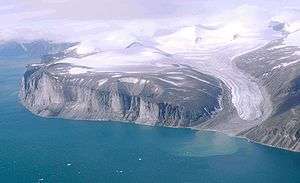
This fjord is reputed for the harsh beauty of its landscapes with rocky cliffs rising steeply from the shore.[2] It is also a popular place with climbers.[3]
History
Sam Ford Fiord had been one of the traditional hunting areas of the Inuit.[4]Sam Ford Fiord (Kangiqtualuk Uqquqti) lies on Baffin Island’s northeastern coast in the Qikiqtaaluk Region of Nunavut. It was named in memory of Sam Ford. Ford is recognized as Canada’s most outstanding Inuk linguist and died tragically in a helicopter crash.
Geography
Sam Ford Fiord stretches roughly from NNE to SSW for about 110 km (68 mi). Its mouth, located between the Remote Peninsula and Erik Point, is over 18 km (11 mi) wide, the width of the fjord narrowing gradually to an average of 3 km (1.9 mi) about 50 km (31 mi) inland. Walker Arm is a tributary fjord branching west from the fjord's western shore about 45 km (28 mi) to the south of its mouth. The Stewart Valley —with its awesome Sail Peaks stretches northwards from Walker Arm's NW corner and connects with the neighbouring Gibbs Fiord. Swiss Bay is a smaller inlet on the eastern shore of Sam Ford Fiord connecting through Ottawa Creek and the Revoir Pass with the inner reaches of neighbouring Eglinton Fiord in the east.[5] The Sam Ford River discharges its waters at the head of the fjord further south[6] and Heimen Island is located within the inner section of the fjord off a small bay 15 km (9.3 mi) to the NNE of the river's mouth.[5]
Sam Ford Fiord is known for its glaciers and its awe-inspiring stark granite cliffs, rising steeply from its shores to heights up to 1,500 m (4,900 ft) above sea level in the area near Swiss Bay. Among the most impressive summits by the fjord Beluga Mountain,[7] Rock Tower,[8] Walrus Head, Broad Peak, Ottawa Peak, Sikunga Mountain, Turnagain Peak, and the Paalik Peak deserve mention.[5]
A massive cliff on the eastern shore located at a bend in the fjord 49 km from its mouth at 70°37′51.82″N 70°55′0.33″W / 70.6310611°N 70.9167583°W has a vertical wall dropping from a height of 1368 m to the fjord's waters.[9]
See also
References
- ↑ "Water Features - Nunavut". The Atlas of Canada. Retrieved 2008-11-11.
- ↑ 4. Bericht von Bord: Die spektakulären Fjorde Kanadas (German)
- ↑ Greenland 2014: Baffin Island and Sam Ford Fjord for Favresse, Ditto and Villanueva
- ↑ Qikiqtani Truth Commission: Community Histories 1950–1975
- 1 2 3 "Sam Ford Fiord". Mapcarta. Retrieved 25 April 2016.
- ↑ NRC Sam Ford River
- ↑ "Beluga Mountain". Around Guides. Retrieved 25 April 2016.
- ↑ North America, Canada, Canadian Arctic, Beluga Mountain and Rock Tower, Sam Ford Fiord, Baffin Island, 1987 - AAJ Climbs And Expeditions, Volume 31, Issue 63 (1989) p. 163
- ↑ GoogleEarth
External links
- The massive rock walls of Sam Ford Fiord
- Steep cliff at the southern entrance of Sam Ford Fjord
- Sam Ford Fjord landscapes
- Sam Ford Fjord - out of this world
- Walrus Head; Time for a Rest
- To the Ends of the Earth - BASE Jumping Baffin Island
- Ted Davenport's Ski-BASE expedition
- Канада Баффинова Земля 2007 (Russian)