Gardner Canal
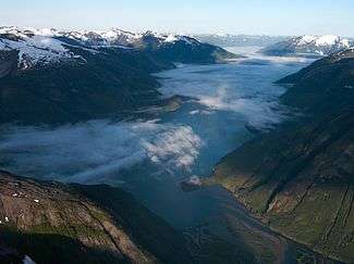
The Gardner Canal is one of the principal inlets of the British Columbia Coast. Technically a side-inlet of the larger Douglas Channel, the Gardner Canal is still 90 km (56 mi) in length in its own right; total length of the waterways converging on the Douglas Channel is 320 km (200 mi) making it one of the largest fjord-complexes in the world. The entrance to the Gardner Canal is hidden behind Hawkesbury Island, and is accessed via Devastation Sound or Varney Passage which form the northeast and southeast flanks of that island. It was named in 1793 by George Vancouver in honour of his friend and former commander, Alan Gardner, 1st Baron Gardner.[1] One of his men, Joseph Whidbey, first charted it the same year.[2]
The Gardner Canal is important for being the location of the Kemano generating station of the Nechako Diversion, which was built to supply power for an Alcan aluminum smelter in Kitimat. The generating station is located about halfway along the canal on its north bank, at the mouth of the Kemano River. At the head of the Gardner Canal is the mouth of the Kitlope River, a major wildlife and wilderness preserve and area of outstanding natural beauty (and harsh weather).
Segments of the Gardner Canal are named "reaches". They are, from mouth to head, Alan Reach,[3] Europa Reach,[4] Barrie Reach,[5] Whidbey Reach,[6] and Egeria Reach.[7] The extreme head is called Kitlope Anchorage.[8] Side inlets include Ochwe Bay,[9] Triumph Bay,[10] Kiltuish Inlet,[11] Owyacumish Bay,[12] and Chief Mathews Bay.[13]
References
- ↑ "Gardner Canal". BC Geographical Names.
- ↑ Vancouver, George, and John Vancouver (1801). A voyage of discovery to the North Pacific ocean, and round the world. London: J. Stockdale.
- ↑ "Alan Reach". BC Geographical Names.
- ↑ "Europa Reach". BC Geographical Names.
- ↑ "Barrie Reach". BC Geographical Names.
- ↑ "Whidbey Reach". BC Geographical Names.
- ↑ "Egeria Reach". BC Geographical Names.
- ↑ "Kitlope Anchorage". BC Geographical Names.
- ↑ "Ochwe Bay". BC Geographical Names.
- ↑ "Triumph Bay". BC Geographical Names.
- ↑ "Kiltuish Inlet". BC Geographical Names.
- ↑ "Owyacumish Bay". BC Geographical Names.
- ↑ "Chief Mathews Bay". BC Geographical Names.
External links
| Wikimedia Commons has media related to Gardner Canal. |
- "Engineers Invade Another Wilderness - Huge Canadian Power Project Marks 20th Century Frontier Boom" , by Richard Neuberger detailed 1951 Popular Science article on the Kemano Hydro Project
Coordinates: 53°34′59″N 128°46′01″W / 53.583°N 128.767°W